Tag Archives: drone

xyHt Weekly News Recap: 08/06/2021
Draganfly Commences Training for Texas EMS Drone Delivery Services The First 4G LTE Connected Drone Hits the Market: Parrot, Verizon, and Skyward Ecopia AI and Hexagon Partner to Create 3D Nationwide Landcover across the USA ANYbotics Boosts Autonomous Mobile Robots with Velodyne Lidar Sensors Bentley Systems Announces Seequent’s Acquisition of Imago
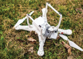
How Not to Crash (or Lose) Your Drone
Lessons from flying, crashing, and occasionally losing, drones
xyHt Weekly News Recap: 07/09/2021
BlackSky’s Technology Monitors Iranian Nuclear Facility Microdrones and GE Launch the GE Industrial Drone Line Ag Department Selects NV5 Global for Geospatial Forestry Contract Graphisoft Releases Archicad 25 Uni-Pact USV Empowers FMS Next-gen Survey Work Esri Announces 2021 ArcGIS Online Competition Winners Satellite Imagery Company Satellogic to Go Public Through Merger New Software System Aims...
xyHt Weekly News Recap: 07/02/2021
Septentrio Announces Partnership with XenomatiX Anguilla Launches New Land Information System from Trimble TomTom’s Advanced Mapping Technology Powers the Nissan Qashqai Volatus Aerospace and ConnexiCore Create Largest Drone Service Provider in North America Inhofe Introduces Bill to make Ligado Pay Everyone Harmed Velazquez Reintroduces Bill Establishing National Database to Combat Rising Sea Levels AB Surveying...
xyHt Weekly News Recap: 06/04/2021
The Earth Archive Virtual Congress – Complimentary Registration ASPRS Announces Government Services Scholarship Pix4D Celebrates 10 Year Anniversary Virtual Surveyor Enhances Stockpile Reporting in Drone Surveying Software CGA’s Fourth Annual Technology Report Details Vision for Ideal 2030 Excavation CATALYST Collaborates with Amazon Web Services to Deliver Geospatial Insights New Mapping Tool Helps Parks Plan for Climate...
xyHt Weekly News Recap: 05/07/2021
Intermap Powers Analytics for Climate Change ConExpo-Con/AGG Unveils New Logo, Brand Identity Bentley Systems Acquires sense metrics and Vista Data Vision Woolpert to Provide Topographic Map of Nigeria TCarta Delivers Satellite Bathymetry for U.S. Coastal Mapping Pilot Deuce Drone Gets FAA Approval for Operations Over People Roadway Asset Mapping Using Any GPS Camera Belgian Farmer...