Tag Archives: energy

A National Imperative
Protecting both legacy and green offshore energy sources with new technologies should be a national priority For the foreseeable future, the world’s economy will depend on energy. This energy comes in two primary types: “legacy” sources such as oil and gas, and “green” energy sources such as solar and wind. Increasingly, nations and energy companies...

A Breath of Fresh Air
To improve urban air quality monitoring and help keep their citizens healthy, cities around the world are now combining traditional data capture techniques with geospatial technologies. If you happen to be driving or walking around Washington. D.C., this past summer, then there is a good chance that you crossed paths with one of the blue...

In the Red
Thermal imagery helps reveal building heat loss Dr. Geoffrey Hay envisioned a solution for an invisible problem in a few milliseconds. Hay, a GIScience professor at the University of Calgary in Alberta, Canada, was perplexed by his higher-than-expected heat bills after moving into his new, modern home that was equipped with “energy-efficient everything.” It was...
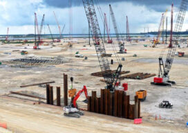
From Texas to the World
A $10 billion construction project will change the future of energy The task of getting clean, efficient energy created and distributed from Texas to the rest of the world is no small-or easy-task. And certainly not inexpensive. But the future of energy may well depend on the process of liquifying natural gas and shipping it...

xyHt Weekly News Recap: 01/21/2022
John Palatiello: 40 Years on the Geospatial Job DOT Makes Historic Bridge Investment Under Bipartisan Infrastructure Law Phase One Unveils Wide-Area Aerial Camera with Global Shutter Sensor Technology Sonardyne Hybrid Positioning Chosen for Vessels Across Energy and Science Seiler Instrument to Expand Presence as a Geospatial Solutions Provider in Iowa and Illinois Kinematic Lidar Data Processing...
Digital Twins for Utilities
More and more cities are recognizing the tremendous benefits that a digital twin provides to: its planners, those responsible for operations and maintenance of city infrastructure including utilities, private architects and engineers striving for compliance with city ordinances and by-laws, and the public. Among the elements essential to developing successful digital twins is recognizing that...