Tag Archives: faa

xyHt News Links: 4/22/16
3D Robotics Announces Transformative New Software for the Solo Smart Drone Platform Topcon and RDO announce expansion to GNSS network service Trimble Announces Call for Speakers for its 2016 Dimensions User Conference Introduction of complete propulsion systems at Xponential 2016 Investigation launched over possible UAV/airplane collision Leica Geosystems launches smart antenna with superior performance DJI Unveils...

UAS Legislative Round-Up
What will 2016 mean for online commercial sUAS registration in the NAS? Online Registration Last year, registration for hobby/recreational sUAS went online. It was so simple I think it has confused people as to what the commercial registration process will look like. Because I have a recreational sUAS and am required to register it, I...

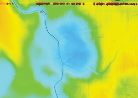
Shedding Light on Lidar
RIEGL USA’s CEO talks about the important trends in the lidar profession. For an inside look at the lidar profession, Heights interviewed James Van Rens, CEO of RIEGL USA. RIEGL provides a wide range of lidar scanning solutions for the aerial mapping and surveying profession, as well as mobile and terrestrial scanning applications. Van Rens...
xyHt News Links: 4/1/16
East View Now Offering PlanetDEM 30 Plus Trimble Seismic Navigation Systems Support Stakeless Operations for Geophysical Exploration Boundless Launches Complete Open Source GIS Platform for the Enterprise Driverless Conference sparks autonomous car development analysis FARO® Introduces World’s First 3D Scan Localizer and the First FARO Innovation Product Introduction in FARO’s new Early Adopter (EA) Program...
An Inside Look
The New FAA UAS Registration Recommendations The UAS Registration Task Force (RTF) Aviation Rulemaking Committee has recently published its recommendations. For an insider’s look, we talked to Altavian’s John Perry, a member of the committee. Unmanned & Unlimited: Could you give us your take on the process? As a representative of MAPPS and as a...
xyHt News Links: 1/29/16
SAM Announces Leadership Promotions OGC announces Arctic Spatial Data Infrastructure Project Topcon to feature mobile solutions center at World of Concrete Major Update of RIEGL’s Terrestrial Laser Scanning Software Suite Now Available Bluesky Boosts Drone Survey Offering with Cyberhawk Partnership FAA hits 3,000 exemptions, 300,000 registrations for UAVs Advanced Navigation releases GNSS/INS post-processing software Eos...