Tag Archives: Galileo

What’s Inside Your GNSS Rover? Part 3
The third and final installment of a look at the inner workings of high-precision surveying rovers. In parts one and two, which appeared in the two previous issues, we focused on antennas, amplification, housing, channels, boards, and gates. This installment continues with signal matching, positioning engines, and additional components. Matching Signals To distill the observed...
What’s Inside Your GNSS Rover? Part 2
The second installment of a three-part look at the inner workings of high-precision surveying rovers. In Part One of this series (xyHt magazine, September 2023 issue) we focused on the antenna, amplification, and housing elements of rovers. This installment continues with channels, boards, and gates. Channels There is a lot of misunderstanding about what receiver...
What’s Inside Your GNSS Rover? Part 1
The venerable GNSS rover, has evolved into an essential part of a surveyor’s toolkit, although some mystery remains as to what that magic box does and how it does it. To demystify this, we engaged GNSS engineers to help craft this three-part “explainer” series. Part one The work of a surveyor requires a lot of...
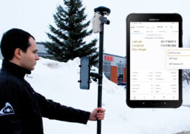
HAS Potential
Free and Global: The new high accuracy positioning service (HAS) of the Galileo constellation and its advantages for GIS and asset mapping If you consider field mapping applications, such as for GIS, asset inventory and management, and field operations for utilities, how wonderful would it be to have sub-foot positioning in real time, with no...

xyHt Weekly News Recap: 06/16/23
University of Maryland and Virginia Tech Earn USGIF Collegiate Accreditation Galileo second gen enters full development phase Large-scale survey of Albemarle Sound underway for NOAA TCarta to Deliver Satellite Derived Bathymetry for 13 Regions to National Geospatial-Intelligence Agency Hexagon’s HxDR Powers Reality Cloud Studio, Ushering Automated Digital Reality into the Cloud Hexagon Collaborates with NVIDIA...
xyHt Weekly News Recap: 02/10/2023
Turkey Earthquake Prompts United Nations to Activate Emergency Satellite Mapping Golden Software Adds Powerful New 3D Subsurface Visualization Functionality Geo Week features sold-out exhibit floor and 2,500+ registrants Esri Joins the Overture Maps Foundation to Help Build Interoperable Open Map Data Digital Construction Week returns for 2023 Galileo High-Accuracy Service Goes Live Interested in Presenting...