Tag Archives: geodesy

Dr. Gladys B. West: The Autobiography of a GPS Pioneer
The inspiring and touching memoir of a pioneering mathematician, Dr. Gladys B. West, who has been recognized and honored for her key contributions to the development of GPS. Gladys Mae Brown Recently published, “It Began with a Dream” chronicles an extraordinary life and is a celebration of perseverance, hard work, faith, and family. Authored by...
GEOID18: Make Your Mark and Improve Your Heights
As a community, we have the unique opportunity to contribute to the densification and improvement of our national geoid model and vertical transformation tools in support of the ongoing modernization of the National Spatial Reference System (NSRS). While the geoid model is a national level product, the impacts of this work are directly felt within...

2022: Monumental Changes, Part 1
The National Geodetic Survey of the U.S. responds to surveyors’ questions on how legacy physical geodetic monuments will be affected by the planned 2022 reference framework modernization. Editor’s note: A recent article in xyHt’s online newsletter, Field Notes, prompted a discussion among surveyors on the pending 2022 modernization of the National Spatial Reference System (NSRS) for...
xyHt Magazine August 2017 Issue
To view this issue as it appears in full in print, click the cover: Below are featured articles from the issue on our website: Editorial Fire, Ice, and Latitude in Ecuador Nicholls State University Geomatics Program Photogrammetric Engineering at The National Polytechnic Institute Drones and Surveying Flood Zones Controlling the Future with Training Women in...
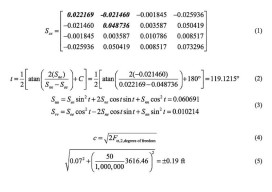
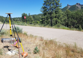
Error Ellipses
Part 2: Components and Increasing Probability In the previous article (April 2017) I discuss the correlation of the coordinate values for a station and how an error ellipse is used to determine the direction of the largest error at a station. In this article I review the components of an error ellipse, the process that...

Weekly xyHt News Links: 6/16/17
RIEGL has received the Sebastian Sizgoric Technical Achievement Award at this year’s JALBTCX conference in Savannah, Georgia. Record attendance for GEO Business 2017 Identified Technologies Aligns with DJI to Offer Best-in-class Commercial Drone Solution Survey and Mapping Company Partners with Leading Unmanned and Manned Flight Service Experts Aeroscout launches UAV helicopter for high-altitude flight Congress increases funding...