Tag Archives: geodesy

xyHt Magazine May 2016 Issue
Click here to view the May 2016 issue of xyHt magazine.

2022
The NGS discusses the upcoming national spatial reference framework modernization. Reference framework shift happens. The National Geodetic Survey (NGS)—the federal steward of the National Spatial Reference Framework (NSRS)—is planning a major (if not fundamental) update of the framework. This pending update is common knowledge among geodetic, surveying, and other geospatial communities. Among the information circulating...

Subsidence
Do you know where your control really is? Editor’s note: The earth moves, even if we do not want it to – or we do not perceive that it does. If you are surveyor working in any part of the country your work will be subject to some degree of subsidence or deformation – be...

xyHt March 2016 issue
Click here to view the March 2016 issue of xyHt magazine.

Fundamentals of Geodesy
Part 1: An Introduction Editor’s note: With this article we start an overview of GeoLearn courses offered by Dave Doyle, former chief geodetic surveyor for the National Geodetic Survey and geodesy editor of xyHt. GeoLearn (geo-learn.com) is an online education business helping professionals reach mandatory continuing education requirements and sort through everyday work issues. Dave’s...
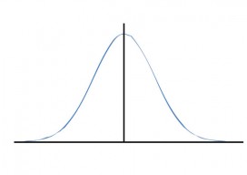
Surveying Statistics
Part 2: The Normal Distribution Part 1 of this series appeared in the May 2015 issue. Errors in observations can be classified as systematic or random. Systematic errors follow physical laws and can be mathematically corrected or removed by following proper field procedures with instruments. For example, the expansion or contraction of a steel tape...