As a community, we have the unique opportunity to contribute to the densification and improvement of our national geoid model and vertical transformation tools in support of the ongoing modernization of the National Spatial Reference System (NSRS). While the geoid model is a national level product, the impacts of this work are directly felt within our cities, counties, and states. Surveyors are especially well placed to contribute in their local regions to improve the model and ensure more accurate local heights.
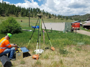
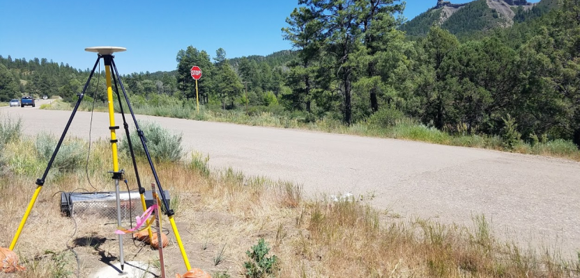
Photo credit: Galen Scott
NGS Mission
The mission of NOAA’s National Geodetic Survey is to define, maintain and provide access to the National Spatial Reference System. The NSRS provides a consistent coordinate system that defines latitude, longitude, height, scale, gravity, orientation, and the shoreline throughout the United States and its territories. It is the framework for all geospatial activities in the nation and impacts a wide range of important activities.
Summary of Activities
Geodesists at NGS are actively improving the geoid model for North America, thus replacing GEOID12B with GEOID18, a new hybrid geoid model to deliver improved GPS-derived North American Vertical Datum of 1988 (NAVD 88) heights. This work will continue with or without public participation, but with participation in your regions the accuracy and quality of elevations will be significantly improved. The result of improved elevations will be enhanced geospatial products related to vital resources such as water and its application in flood determination and flow. NGS has compiled a prioritized list of bench marks to target for GPS data collection by community partners. These community-collected data will need to be shared and provided to NGS. The project will use recently collected data to constrain the geoid data to NAVD 88 bench marks as the model is being generated, thus allowing for further optimization locally and regionally.
The Near-term Vision 20/20
GEOID18 will be the last “hybrid” geoid model that NGS creates before NAVD 88 is replaced by the North American-Pacific Geopotential Datum of 2022 (NAPGD2022). The benefits of community-collected “GPS on Bench Marks” data contributions will persist beyond GEOID18. As NAPGD2022 is being created, a transformation tool will transform NAVD 88 heights to NAPGD2022 heights based on these contributed data. Iterations between the development of the new datum and the transformation tool will continue as NGS moves towards its 2022 mission goal. This future tool will form the building blocks and backbone of the ever-improving vertical translational tools in the “NGS Tool Kit.”
History of GPS on Bench Marks and Geoids
The nation’s height system (NAVD 88) is rooted in historic geodetic leveling surveys that use approximately 500,000 published bench marks, most of which have not been positioned with GPS. NGS’ current hybrid geoid model, GEOID12B, relying on about 25,000 “GPS on Bench Marks” observations, provides GPS access to NAVD 88. For the past several years, NGS has been asking stakeholders to collect, submit, and share their data to improve the NGS models and tools as part of the GPS on Bench Marks program.
Northern Wisconsin is an example of an area that has been greatly improved since GEOID12B through additional observations (Figure 1). The marks highlighted in green are new marks that were not available for GEOID12B. A prototype of the GEOID18 model was created using this new data and excluding older previously used data, and the changes in the geoid model range from 2-5 cm throughout the entire region. Northeastern Wisconsin and portions of the Upper Peninsula of Michigan have areas showing 15 cm changes from GEOID12B to the new prototype (see dark blue area with red “X” at top of figure).
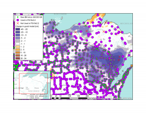
Figure 1: Prototype Hybrid Geoid Model (PG18v2.2). This is what GEOID18 would look like today with the current data. Green circle marks are new bench mark observations since realization of GEOID12B.
Does It Really Work?
The nation’s vertical datum needs to evolve to support the geospatial needs of today and tomorrow. While we are working on replacing NAVD 88 with NAPGD2022, we are also working to improve models and tools related to NAVD 88 to facilitate the transition to the new datums. The geoid calculations are complicated and rely on measured ground surface relationships among ellipsoid height, orthometric height, and geoid undulation. If left unconstrained by GPS on bench mark data (surface measurements), the interpolation used in creating the hybrid geoid model can produce features that, while correct scientifically, may deviate from the expected NAVD 88 at the user level.
The closer the bench mark observation is to a location of importance, the more influence it has on the geoid calculation. NGS has found that constraints on the model at a distance of about 30 km (~18.5 miles) are potentially significant at the local level. Figure 2 shows a hypothetical situation using the current distribution of marks in Wyoming. A single mark (at the center of the “target”) is given an artificial 20 cm of misfit. This 20 cm is a crucial level as it is right at the edge of what NGS can decipher as signal versus noise. Look at the labels on the marks throughout the region to get a sense of what ranges are present and ask yourself, “Is this signal or noise?”
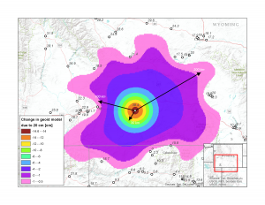
Figure 2: Hypothetical signal or noise? Map showing how a potential discrepancy in the ellipsoid measurement can impact the geoid calculation.
If your answer is a “real” signal and that it should be included in the model, notice that the model doesn’t reflect a change of -20.0 cm. The model seemingly only changes by -14.6 cm as surrounding bench marks “pull” the model into better agreement with the surrounding region as if it were bound by rubber bands. The surrounding bench marks also control how the 20 cm disparity is spatially distributed and constrain the impact where they are present. The key takeaway is that a 20 cm improvement would result in a 1 cm change in the model at distances up to 200 km around the misfit bench mark!
A more likely scenario is that this misfit bench mark is actually noise, and NGS wants to avoid modeling these misfits. The good news is that we can test for this in a practical way by simply surveying this bench mark with multiple independent GPS observations. We recognize that additional leveling would help NGS isolate and fix some suspect marks; however, this is not an efficient use of time or resources.
Distilling It Down to a “Yes” or “No”
Additional high-quality GPS observations allow NGS to isolate local and regional problems and repair them through examination. Ultimately, this results in increased confidence that the model is an improvement. NGS has compiled a suggested priority list of passive control at the local level with stated minimum observation requirements for acceptance into the hybrid geoid model. These marks were selected to fill data “gaps” with a broad brush national perspective (no local knowledge). It is not an exhaustive or static list, as some of these marks may not exist, are not GPS-able, or are in inaccessible or dangerous locations, and thus other marks in those regions would be better choices. Using these marks as a starting point, many state and local entities and geospatial groups are planning supplemental data-collection activities. Information can be found at the NGS “GPS on Bench Mark” website.
In addition to the “gaps” of “GPS on Bench Mark” data that NGS has used to identify high-value marks (and maps thereof), another critical target is collecting new data (or additional data) on NAVD 88 bench marks in areas of importance, such as known or possible subsidence areas (particularly if marks in those areas have been used in previous geoid model development to provide access to NAVD 88). This is critical in helping NGS identify marks that are no longer valid (using the published orthometric height) for developing the geoid. It would be better to interpolate the gravity surface across these areas than to constrain to a published height that is now invalid.
Once the Work Is Done: How Well Will the Marks Fit after Modeling?
Hypothetically, looking ahead to GEOID18, Figure 3 shows what the resulting residual values would be throughout the region. Most values are in good agreement, to less than 1.5 cm. The two marks (red “X”s) have noticeably larger residuals (-6.6 cm and -18.6 cm) and are not used in this modeling example; however, these two marks were used in the creation of GEOID12B as NGS didn’t have sufficient density of surrounding marks to constrain the model at the time.
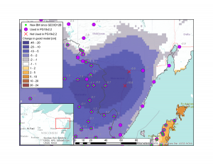
Figure 3: NE Wisconsin area showing resulting residual values (in cm) if the model were completed today.
Figure 4 is a scenario that includes the two suspect marks. The two marks fit better, but look at the surrounding marks. Now, the model shows peak changes on the order of 8.5 cm where the two nearest marks have residuals of ~4.5 cm compared to 0.7 cm and 1.5 cm in Figure 3, resulting in 3 cm in the wrong direction. The three marks impacted along Lake Michigan actually show a very minor improvement (~1 cm). The 3+ cm degradation is what NGS is attempting to avoid at this level as it is detectable by a local surveyor.
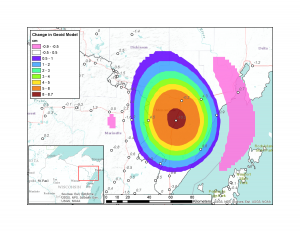
Figure 4: Hypothetical scenario that includes the two suspect (red “X”) marks omitted in Figure 3.
Contribute
NGS is requesting that the identified priority marks be observed and submitted to NGS through its Online Positioning User Service-Share (OPUS-Share), one of the NGS’ core geodetic tools that processes GPS user data and sends the results to the submitter via email. All data must be shared with NGS by August 31, 2018, to be considered for inclusion in GEOID18.
Additionally, DSWorld can be used to submit mark recoveries to let NGS and other surveyors know if a given mark is still there, accessible, and suitable for GPS observations. DSWorld can be downloaded from geodesy.noaa.gov/PC_PROD/PARTNERS/. Working together will lead to the determination of areas where having a more robust geoid would not only improve the national geoid but also the local heights. The impacts will be far reaching, such as improved accuracies in GPS and GNSS heighting, local and regional vertical control, and better water resource measurements, including those found on flood maps.
The requirements are easy! Each prioritized mark must be observed a minimum of two times (more is optimal) and have a minimum occupation of four hours (more time is preferred and more robust), and each observation is to be on different days and preferably separated by days to weeks and be shared with NGS. Sharing is easy through NGS’ web-based “OPUS-Share.” Once the GPS data have been collected, all you need is minimal metadata that includes two photos of the setup. We strongly suggest exceeding the minimum effort with a little extra time on marks and regular re-occupations. After all, it is your community tie and your opportunity to make your mark on heights!
Photo credit: Galen Scott
While the National Geodetic Survey’s primary mission is to “position America,” the opportunity to collaboratively address your height needs at the regional and local levels just makes sense. This is an example of where the federal mission and societal needs are in alignment, and dedicated citizen scientists, as well as geodesists at NGS, can collectively help the public by interacting and describing their environment a little better.
NGS is extending its hand to welcome your participation in improving your local height infrastructure, through collaboration and sharing, while we work towards completing our national vertical mission. This is an exciting time to be updating our reference infrastructure, and, with your cooperation, we look forward to doing a better job! NGS is actively keeping your needs at the forefront of what we do, especially considering all of the geospatial disruptive innovations and improvements that are occurring today. By working with the public on initiatives such as “GPS on Bench Marks,” we can build a better framework and increase our understanding of the world in which we live.