Tag Archives: geodesy
I Don’t Need No Stinkin’ Statistics
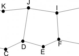
Surveying Statistics, Part 1 Do you perform GNSS surveys? Do you use OPUS or perform RTK surveys simply because you don’t understand your software’s output? Do you always use the compass-rule adjustment for traverse data simply because that’s the way you have always done it? Do you ever have a situation where you know something...
Transformation of Observations, Part 3
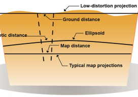
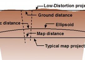
Above: Typical and low-distortion map projections. Using a Project Factor In Part 1 of this series of articles (September 2014 issue), I explained how to transform surface observations into a geocentric coordinate system so that it could be compared to GNSS baseline vectors. In Part 2 (December 2014) I explained how the creation of a...
xyHt: A New Magazine
Like so many ideas in surveying, starting this magazine started over a beer at a great little Irish pub with friends, where we discussed what the landscape of surveying might look like in the not-so-distant future. I figure, during the course of almost 50 years that I’ve been a geodetic surveyor, virtually all parts of...
Not Always Better With Age
Some things get better with age; some do not. Surely this is true for wine, but not sake or unrefrigerated shellfish. In the past we would view something that was made or had been established years past as holding invariant weight or authority. This was often because the effort to make or establish the item...
CGVD2013, Part 2
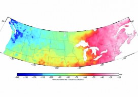
Above picture: This color contour map shows the difference between CGVD2013 and NAVD 88, especially of interest to those who work on projects along the U.S./Canada border. In part 1 of this series in xyHt’s October issue, Canada’s new vertical datum is introduced—CGVD2013— with an overview of past Canadian datums, directions during the current transition...
Transformation of Observations Part 2
In my previous article in the September issue, I demonstrate one method of taking conventional/optical observations and converting them into GNSS baseline vectors. Here I demonstrate how to create a map projection system that is near the ground, and thus on the surface we survey. These map projections are commonly referred to as low-distortion projections;...