Tag Archives: Leica Geosystems

xyHt Weekly News Recap: 01/20/2023
Register for GeoWeek GeoConnect Asia to be Held in Singapore in March FIG Working Week 2023 to be Held in Orlando May 28-June 1 Glenville State University Professor Invents New Survey Tool Leica Geosystems Simplified Utility Detection; Helps Site Safety How to Diversify Your Workforce Talent Pools with Intention (and Maximize Results) AI Deep Learning...
xyHt Weekly News Links: 04/24/2020
Data Analysis Recovers $2.27M in FSRM Funding at Air Force Base Teledyne Lumenera’s Lt Series USB3 cameras built around Sony’s finest sensors NASA has a video game to map coral reefs around the world Commercial UAV Expo Americas to take place as planned Sep 15-17, 2020 in Las Vegas Leica Geosystems and Geomap cooperate to...
Weekly xyHt news links: 2/21/20
Leica Geosystems brings the world’s first MultiStation to the next level Leica Geosystems announces new most accurate total station LAND INFO Announces 5G Wireless Mapping Team in Europe
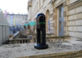
The Leica BLK2GO: A GRANDSLAM Device
Hexagon Geosystems’ nifty-looking Leica BLK2GO makes geospatial data more accessible to GIS and BIM professionals—as well as to expert surveyors. On a cold, frosty day in December, I’m walking around a skating rink in London with what looks like a device stolen from Doctor Who’s TARDIS. With its sleek exterior and ergonomic design, the Leica...

World’s Biggest Digital As-built?
Above: Darling 3D scanning division manager Charlie Warren checks his settings while scanning the Mercedes-Benz U.S. International automotive plant. A whopping 1.5-million square feet of a Mercedes-Benz facility expansion was scanned for as-built documentation and construction verification. A GROWING geospatial application of 3D digital data from laser scanners is for as-built documentation and construction verification....
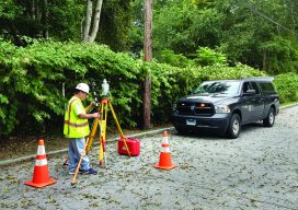
Examining Captivate
Above: A crew chief with BL Companies of Connecticut begins his day working with Captivate. The evolution of 3D surveying field software and Leica Geosystems’ Captivate might surprise you. Editor’s Note: Captivate has been widely implemented among Leica Geosystems users for several years now. In many ways it was a dramatic leap for Leica Geosystems—going...