Tag Archives: lidar
Lidar and Surveying: Infrastructure Relies on Surveys
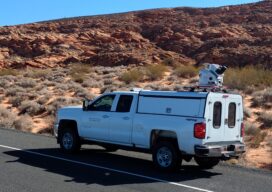
Mobile lidar platform provides engineering firm with data sets for multiple deliverables In the past, project teams couldn’t get high-quality, actionable data quickly when performing surveys—there was always a trade-off between time and quality. However, advances in mobile lidar technology are significantly reducing the time it takes to collect data while still meeting strict accuracy...

xyHt Weekly News Recap: 03/04/2022
Register for the March 30 NSPS Day on the Hill Carlson Go West 2022 Set for April 4-6 ProStar Granted Major Patent for Utility Data Management RIEGL & Deswik: Providing a Fast and Efficient Workflow for Mine Surveying Emesent Hovermap Sets Survey Grade Standard for Autonomous Lidar Mapping NCEES Seeks Professional Surveyors’ and Mapping Scientists’ Expertise...
xyHt Weekly News Recap: 02/25/2022
Register for NSPS Virtual Day on the Hill by March 1 Aero-Graphics Contracted by U.S. Army Corps of Engineers 3D at Depth Receives Patent for Monitoring Underwater Structures Lidar Survey Reveals More than 400 ‘New’ Archaeological Sites in England Airbus to Provide Imagery that Enables Crop Analytics SkyGrid Launches All-in-One Drone App for iOS Globally...
22 Young Geospatial Professionals to Watch in 2022 – 22 of 22
Throughout January and February xyHt.com is featuring young geospatial professionals who are making a name for themselves in everything from surveying to geographic information systems. xyHt featured all of them in the Name: Teresa Zgoda Company: Phase One Current Position: Systems Support Engineer Age: 26 Education: BS in Biomedical Photographic Communications Biography: Teresa provides technical...
xyHt Weekly News Recap: 02/04/2022
National Surveyors Week March 20-26 Trimble Dimensions+ 2022 Call for Speakers Now Open Teledyne Introduces CZMIL SuperNova Lidar Bathymeter Bowler Pons Deploys Cepton’s Smart Lidar Solution to Augment Security for Critical Infrastructure ASPRS Announces February 2022 GeoByte! Riegl VZ-20001 Used for Permanent Forestry Monitoring Aeva Introduces Aeries II, World’s First 4D Lidar with Camera-Level Resolution...
22 Young Geospatial Professionals to Watch in 2022 – 21 of 22
Throughout January and February xyHt.com is featuring young geospatial professionals who are making a name for themselves in everything from surveying to geographic information systems. xyHt featured all of them in the January issue. Here we will spotlight one each day. Name: Denver Winchester Company: Crafton Tull Current Position: Vice president Age: 32 Education: Associate...