Tag Archives: lidar

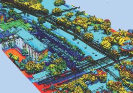
Street-Level Lidar On Demand
As exciting as the advent of on-demand access to current, high-resolution lidar is, so are the tools available for ingesting, extracting features, analyzing, and sharing. “What we’re hearing right now, this is really an inflection point for the industry,” says Phil Christensen, vice president for reality and spatial modeling at Bentley Systems. “The software has...
Solving the Problems that Matter
Pickett and Associates provides aerial LiDAR and imagery, land surveying, hydrographic surveying, and engineering services to clients throughout the U.S. and Caribbean. Pickett specializes in offering the simultaneous collection of high resolution 4-Band Aerial Imagery together with engineering-grade airborne LiDAR, allowing us to turn around baseline imagery and LiDAR-derived data quickly and efficiently. We deliver...

UAVs and Living Data
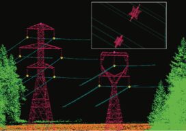
Digital twins are becoming important data for buildings and infrastructure in cities, but a utility in Chile is twinning its power corridors and adding seemingly unrelated data to identify, predict, and avoid power outages. We live in an era of combining technologies. For the past few decades, we have witnessed the most impressive movement of...
Empowering Utility Engineers to Make Informed Decisions
Aerial Services, Inc. (ASI) has been a leader in the geospatial industry for 55 years, offering turn-key solutions for lidar, orthoimagery, obliques, and geotagged 4k video supporting a multitude of applications, including above ground utilities. ASI provides rapid turnaround and high-quality mapping to assist utility engineers throughout the design, build, and inspection process. ASI’s utility...
xyHt Digital Magazine: May 2022
Like a good surveyor, xyHt’s May issue covers a lot of ground, bringing you stories about UAV/UAS, Lidar, Aerial Imagery and Mapping. As always, if you don’t have a subscription to our print edition, or if someone else in the office has snaffled your copy, don’t fret, here is the digital edition. Click here or on...
Geospatial Excellence
MAPPS recognizes the best geospatial projects of the year At its winter conference in Denver, MAPPS presented the annual Geospatial Excellence Awards to member firms whose entries exemplify the professionalism, value, integrity, and achievement of the firm’s staff as demonstrated over the previous year. The awards spotlight and honor the MAPPS members’ important and impactful...