Tag Archives: NSRS

Putting the Best Foot Forward
Surveyors’ Corner We are upon a solemn moment in the land surveying profession. Yes, we’ve all known for a while that this end-of-era moment was coming, but now it ends without pomp or circumstance, without the formality of an obituary, without even a memorial service. We bid adieu to a long-faithful companion that, for all...

xyHt Weekly News Recap: 10/14/2022
New NSRS Modernization Release Timeline: Mid-2025 Geo Week Calls for Nominations for Excellence in the Geospatial Industry Trimble Changes Headquarters to Westminster, Colorado Mapping Site ShowMyMap.com Rebrands to Mapize.com DOE Announces First Cohort of Post-Secondary Programs to Receive New Zero Energy Design Designation Ashley Hitt to Serve as President of URISA SmartGeo Expo 2022 to...
The March toward 2022
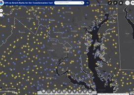
Above: A screenshot of the GPS on Bench Marks web tool mobilized in 2018. NSRS modernization: What NGS is doing and what you can do. “The only thing that is constant is change.” – Heraclitus Although this quote pertains to all of life, its truth is especially painful for professional surveyors and geospatial professionals. But...
State Plane Coordinates 2022
Ready or not, here they come. Considering all of the outreach that the National Geodetic Survey (NGS) has been doing for the last couple of years, hopefully most of you are well aware of the National Spatial Reference System (NSRS) Modernization Project. That project will result in the replacement of both the North American Datum...
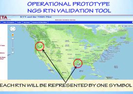
How Accurate Is an RTN?
Many surveyors have realized the benefits of using real-time GNSS networks (RTN) for survey-grade positioning. Saving time, equipment, and personnel means saving project costs. The thing about real-time GNSS surveying, however, is that “rover expertise” needs to be applied in the field (not the office). Additionally, many factors involved with GNSS signalization, as well as...

The Modernized NSRS (A Summary)
Editor’s Note (from Scott Martin): When I learned that NGS and Dru Smith (the NSRS modernization manager for the NGS) had requested to respond to my August Field Notes, I was quite intimidated. However, my fears were quickly quelled. Thank you, Dr. Smith! As mentioned below, a more extensive and informative response on the monumental...