Tag Archives: Pix4DMapper
Mapping Rwanda: Surges Forward in UAS Mapping Use
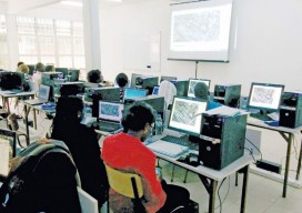
From cadastral to precision agriculture to humanitarian aid, UAS are making a big difference while mapping Rwanda. (Above: Course participants examine an orthomosaic in Pix4Dmapper during software training.) After Rwanda made waves in the news early last year for allegedly being the first country to approve drone delivery, people payed attention. The country, with its rolling...
Pix4D Mapper
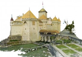
Imagine walking up to an object with practically any camera and taking photos of it at different angles. Now imagine uploading those images onto a computer and being able to create a survey-accurate point cloud. Sounds impossible, huh? Too good to be true? That’s what I thought when I first heard of Pix4D. When I...