Tag Archives: PPK
UAS Processing as a Service
Speed, improved workflows, scalability, and analytical tools have boosted the popularity of such services—especially in these times of staffing challenges Creating deliverables from your UAS captured data, orthophotos, point clouds, photo meshes, and terrain models, can put a premium on the skills of your staff and processing resources. This is why an increasing number of...

xyHt Magazine Digital Edition: December 2021
Like a good surveyor, xyHt‘s December issue covers a lot of ground. This month we bring you stories about surveying, lidar, legal issues and an in-depth look at the emerging post-processing kinematic technology. As always, if you don’t have a subscription to our print edition, or if someone else in the office has snaffled your copy,...

xyHt Weekly News Recap: 7/7/17
Tersus launches a ‘new generation’ NeoRTK system senseFly announces worry-free service package to keep professional drone operators flying Surveying the World of Tomorrow CompassCom to Release CompassTracker App for iOS & Windows Mobile Smart Phones at Esri User Conference Trimble Catalyst high-accuracy, on-demand geolocation service now available worldwide Quorum Launches myQuorum Land On Demand, Bringing Speed...
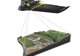
UAS Surveying without GCPs
The subject of applying direct georeferencing to UAS platforms was a recurrent theme at the 2016 Commercial UAV Expo last week. Direct georeferencing offers the possibility of mapping without the use of ground control points, providing UAS operators a significant advantage in terms of speed. As an example of this technology, we reached out to...
xyHt News Links: 10/7/16
GeoSLAM (handheld laser scanning) and Blackdog Robotics (unmanned robotic vehicles)partner for remote surveying in hazardous environments/uneven terrain TerrAvion Launches First Aerial Imaging Solution Specifically Designed for Rangeland Trimble Changes Name to Reflect Company’s Technology Evolution Teledyne Optech to introduce new static and mobile surveying solutions at INTERGEO 2016 senseFly to Unveil new RTK/PPK-Ready, Large Coverage Mapping Drone at INTERGEO 2016...