Speed, improved workflows, scalability, and analytical tools have boosted the popularity of such services—especially in these times of staffing challenges
Creating deliverables from your UAS captured data, orthophotos, point clouds, photo meshes, and terrain models, can put a premium on the skills of your staff and processing resources. This is why an increasing number of firms with drone programs are turning to service providers.
The decision facing surveying and mapping drone operators falls to three basic propositions: process in-house, send the data to a service provider, or utilize a web-based processing service.
Firms are struggling to attract and retain skilled staff and keep up with present unprecedented demand. In-house processing resources may be limited and not sufficient to scale up to take on more and larger projects. While cloud servers can be tapped, like Amazon Web Services (AWS) or Azure (Microsoft), this can be challenging as it requires a skillset to incorporate into workflows in a cost-effective manner. Fortunately, there are helping hands if needed.
DIY and SaaS
James Michel is an imaging scientist, having studied imaging science at the Rochester Institute of Technology, and after working in many roles in the industry, is now the director of business development for North America for Skyline Software Systems. Skyline was established in 1997 to serve industry sectors that needed to process massive imaging datasets, like defense, geospatial intelligence (GEOINT), and large government entities.
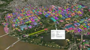
Features in 3D photo meshes can be classified and attributed, for example, buildings and other features from flights over the National Mall in Washington, D.C. Source: Skyline
More recently, Skyline has expanded these services for the commercial sector: utilities, surveying, construction, and municipalities. While not alone in officering such services, Skyline has been able to leverage the scalability and analytical tools it first developed for the original sectors the company served.
“We support three workflows,” said Michel. “You can run our software in-house or use our software-as-a service (SaaS) option to process UAS captured data you have captured or acquired and use our suite of analytical tools. Or you can send us the raw images with the appropriate metadata, and ground control points (GCPs) or lidar to enhance models if available, and we will process it for you. We also have a web portal where you can upload your raw images, pick a few options, and it processes this and delivers your products back to you.”
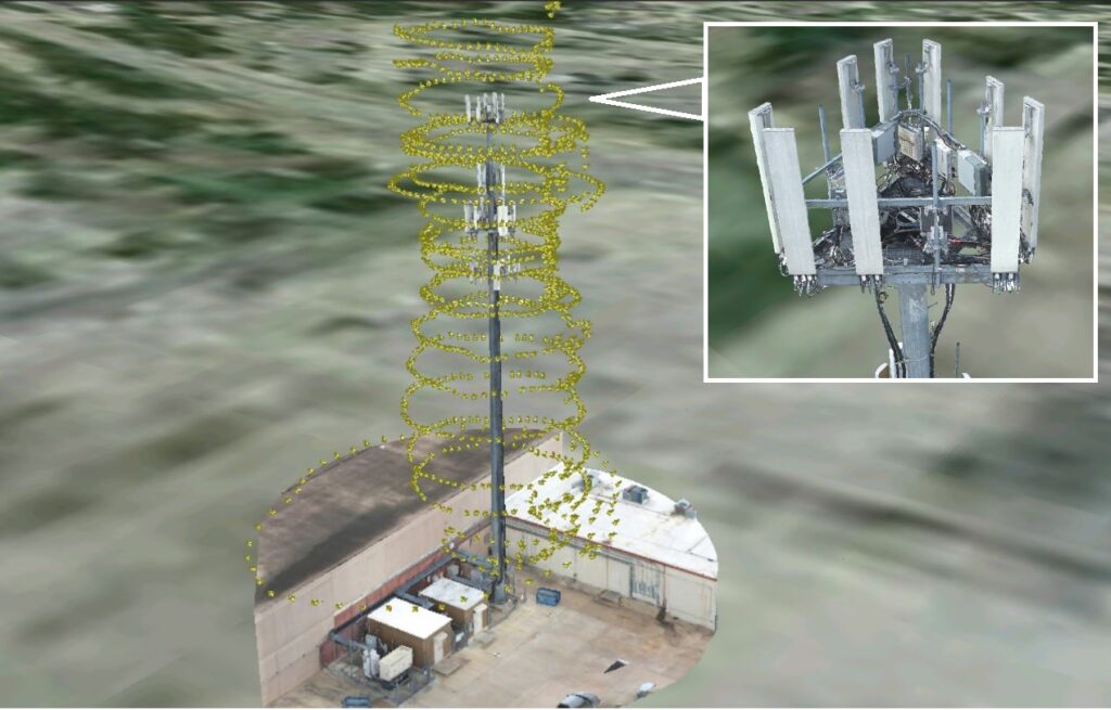
Inspection is another common use for UAS generated photo meshes. Shown here are positions of the photos used from a flight to a 3D model for inspection of a communications tower. Source: Skyline
If workflows can include the geo-location step, processing the GNSS/IMU, the PPK processing, then in-house or direct submission for processing can be good choices. But it’s not a necessary step: if you have the raw images and metadata or lidar, and GCP, both in-house and direct submitted will yield precisely geo-located deliverables.
“Metadata is key. Data from supported cameras, lidar, and ground-based sensors, generally include the coarse location, pitch, yaw, roll, etc.,” said Michel. “This can be all that is needed, plus GCPs, to run this though the Skyline platform.”
“Deliverables fall into four categories,” Michel continued. “3D mesh models are fairly standard for most clients. This provides flexibility in using analytical tools. But then there are points clouds that can be valuable for classification, feature extraction, and for heads-up drafting of features. Of course, we also provide rectified true orthophotos, and lastly, many clients want digital terrain models. We can output into many standard model formats for your extended uses or use our TerraExplorer for further analysis.”
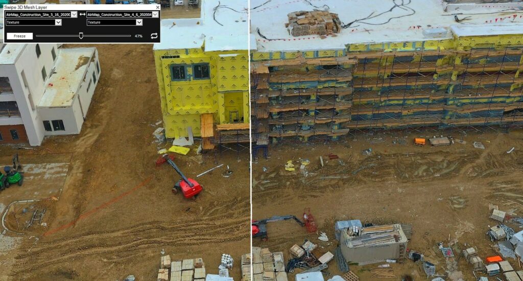
A slider tool to compare photo meshes of this vertical construction site shows project progress. Source: Skyline
Clients will also want to know the data quality and the analysis of precision. This is almost always a standard output when you process yourself in photogrammetry software, and this is no different for SaaS. Skyline provides accuracy reports for any data the company processes, and it has a photo inspector tool to see what images were included and to view them side-by-side with the 3D Model.
“Often we see UAS missions that are done in standard crisscross patterns,” said Michel. “But we have clients who add extra flights, like an orbit around a specific feature or structure. We process all of this together and provide quality information for each image used.”
Shake and Bake
Depending on the needs of a project, a plethora of readily available imaging and data resources can be tapped. For instance, many parts of North America have ready-to-use images, and in some cases even lidar. Image as a service (IaaS) vendors like Eagle View, Vexcel Data, Sanborn, Woolpert, Fugro, Nearmap, and others are flying wide swathes of North America, in many cases offering images on-demand. The Hexagon Content program offers images, and elevation data, and street-level lidar is now available for many roads in 50 countries from HERE.
The challenge is currency. Some of the IaaS providers are flying the entire country every one or two years but flying major metropolitan areas more frequently. If the most-recent data is current enough for a project’s needs, and especially if the raw images can be purchased, it can all be submitted to a service like Skyline for processing into desired deliverables. Many of these IaaS service providers can also be contracted to fly specific areas of interest. And there is a small cottage industry of UAS imaging vendors that can be tasked with near-Uber-like business models.
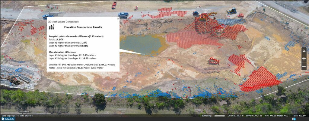
Successive UAS flights for change detection over construction sites is a common use. Analysis tools show the changes and provide volumetric data as attributes attached to the 3D photo-mesh. Source: Skyline
As an example, Skyline works closely with EagleView. If an existing EagleView customer, such as a city or county wants to create 3D deliverables, and the date of the most recent images meets their needs, the 3D Models and imagery is available directly from EagleView. Similarly, Skyline can process images from vendors like Aerometrex that do contract imaging and also have a library of many parts of the country that they fly on a regular basis.
Scalability
If a surveying firm is looking at taking on a lot more work—and there is a lot more work out there right now—SaaS offers a solution for scalability. Again, having to add more servers to process large projects—or many more projects—can prove to be a logistical and budgetary nightmare.
“We can scale up processing to a county, state, or even country level. We have a lot of experience with this for our defense and GEOINT customers,” said Michel. “But we’re also seeing this for our commercial customers.” As an example, one of Skyline’s current customers is doing utility tower inspections on a grand scale, capturing as many as 50 towers a day.
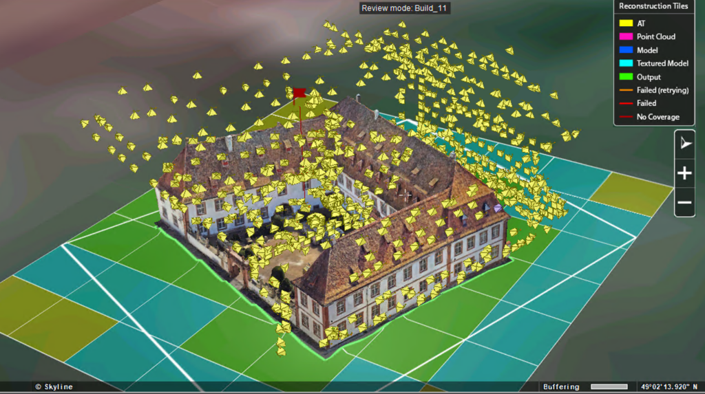
Photo positions from multiple UAS flights, processed together are shown in this photo inspector tool. Attributes and quality information for each image is attached to the respective symbols. Source: Skyline
“If you have 100 machines on your network, you can process up to 100 times faster,” said Michel. Then you would need a network administrator who was up to managing those. “Cloud services like AWS are what we tap for big data situations,” adds Michel. “Using as many as we need when we need them. And recently AWS has changed to charging by the minute, instead of simply rounding up to the hour. This makes it much easier to plan for costs when working large scale processing tasks.”
Analysis
Typically, the model is just a step in achieving what the client is really interested in. For instance, a construction firm might want repeated flights for change detection, gauging progress in earthworks, materials stockpile volumes, or slope analysis. They may opt to hire a surveying firm that not only flies and models the data, but one that can also extract the actionable data they seek. Models can be put into certain survey office software or civil CAD suites to do this, but again, the skilled staff is needed to do this. Skyline has canned many of these standard analysis functions into their TerraExplorer visualization and analysis suite.
Taking on More Work
As noted: while not alone in providing UAS processing as a service, Skyline is a good example for projects large and small; especially to scale up operations.
As surveying firms seek to take on more of the abundant work out there, and to take on more analysis tasks for their clients, as opposed to just doing the data capture and models, some level of automation is inevitable. We see this as well for firms that use CAD feature extraction services for ALTA surveys.
Certainly, surveyors need to pay close attention to the deliverables from any work they have others do for them, but the tools have gotten much more sophisticated and reliable. You can fly as much as you want now that there are resources to help process it all.