Tag Archives: remote sensing

Encoding Geography: Scale Up to Keep Up
America’s foremost community of professional geographers wants all students, especially women and minorities, to have a head start in geocomputational abilities. A revolution in teaching geography is in the offing. Demand for professionals with geospatial skills is on the rise. In 2019, expertise in geospatial technology was listed by Upwork, a global job website, as...

New Digital World Needs Data
Next-generation surveyors require specialized education and training to fill the role of geospatial data specialists. Many emerging geospatial applications, such as digital twins, 3D modeling, monitoring, virtual reality, and autonomous vehicles, are based on big digital datasets. Building a 3D digital world starts with accurate data that ties to a point on the ground, so...
Geospatial Excellence
MAPPS recognizes the best geospatial projects of the year At its winter conference in Denver, MAPPS presented the annual Geospatial Excellence Awards to member firms whose entries exemplify the professionalism, value, integrity, and achievement of the firm’s staff as demonstrated over the previous year. The awards spotlight and honor the MAPPS members’ important and impactful...

When a Drone Just Can’t Do It
There is a growing ebb in the tide of UAS adoption for aerial surveying, mapping, and remote sensing—finding the right balance between manned and unmanned aerial operations Unmanned aircraft systems (UAS), remotely piloted aircraft systems (RPAS), or just plain old “drones”—call them whatever you wish—have had a tremendous impact on geospatial industries. A decade ago,...
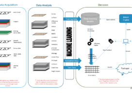
How Deep Learning For Remote Sensing Produces Quicker, Higher-Quality Results
As the volume, velocity, and variety of the data generated to address worldwide geospatial needs has steadily grown, advances in the systems and algorithms needed to produce spatial and temporal resolution data have not kept pace.
xyHt Magazine Digital Edition: September 2021
xyHt's September issue includes features on UAVs, deep learning, oceanography and adventure.