Smart sensors and satellites are being used to actively monitor bridges and large infrastructures. With eyes in the sky and ears on the ground, can this new technology improve public safety?
Despite what the lyrics of the popular English nursery rhyme may have our young ones believe, the London Bridge has actually never fallen down.
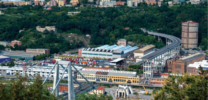
What remained of the collapsed Morandi Bridge in Genoa, Italy, connecting the A10 motorway after structural failure during a thunderstorm and heavy rain on August 14, 2018.
Located in the capital and largest city of the United Kingdom, the famous bridge that spans the River Thames has instead undergone several makeovers since a stronger structure was built there in 1176, replacing the original wooden bridge that dated from the late Roman period. What stands nowadays is a modern bridge that was opened to traffic in 1973.
Constructed using concrete and steel following modern techniques, the new London Bridge has since shown its mettle. In 1984, the British Warship HMS Jupiter collided with the bridge when a strong river tide swept the frigate toward one of the viaduct’s columns. The accident caused significant damage to the ship, bending its mast and damaging its radar. The bridge, on the other hand, was only slightly damaged. It remained open to vehicular traffic and was abruptly repaired.
Yet, not all bridges are as strong, or lucky. During the summer of 2018, the Morandi Bridge in Genoa, Italy, suddenly collapsed, leaving 43 fatalities in its wake. As a torrential storm battered the city on August 14, one of the cable-stays of the bridge snapped, sending a section of the concrete bridge, including several individuals who were inside their vehicles, plummeting to the streets and a portion of the Polcevera River some 45 meters (150 feet) below.
The Morandi Bridge built in 1967, was designed to last at least 100 years. But several compounding factors, including structural problems, poor maintenance, and heavy traffic, among others, triggered its breakdown. It lasted only five decades.
While a case filed by families of the victims is now being heard in Genoa courts, a new bridge replacing the Morandi Bridge has been constructed in record time. Designed by the architect Renzo Piano, the new $239.9 million viaduct was inaugurated in 2020 after only 15 months of work.
Bridges Over Troubled Surfaces
There are many factors that can lead to the collapse of bridges, writes Arturo E. Schult of the University of Texas at San Antonio. In the book Innovative Bridge Design Handbook released last year and written together with Alesso Pipinato and Andrew J. Gastineau, the authors say that most bridge failures are caused by human error, especially during the design and construction stages, including poor materials choices that lead to corrosion. Still, strongly built bridges can collapse as well, especially when proper maintenance is lacking or when the maximum permissible weight limit of the viaduct is exceeded, a term that is called vehicular overloading.
For instance, design flaws and vehicular overloading were cited by investigators as the cause of the breakdown of the I-35W Bridge in Minnesota, a tragedy that left 13 fatalities and more than 140 injured people. The accident, which happened during the early evening rush hour traffic of August 1, 2007, helped shift the public’s focus on the importance of bridge safety in the United States. Owing to local pressure, the legislature of Minnesota approved an increase in funding for statewide road and bridge maintenance. Many more states followed suit.
Yet, even if bridges are carefully maintained, there is another set of uncontrollable factors that may lead to bridge collapse. According to Schult and his co-authors, earthquakes and fires, as well as impactful collisions, often cause bridge failures. For example, the collapse of the iconic Sunshine Skyway Bridge in 1980, in Tampa, Florida, happened after a freighter accidentally rammed into the support columns of the bridge during a morning of heavy fog and rain. A portion of the viaduct fell into the sea and took 35 lives.
Do You Hear What I Hear?
Like all other transportation infrastructures, bridges are important for the movement of goods and services in a functioning economy. But unlike highways and railroads, the maintenance of bridges is even more critical because of their complex structures and precarious locations that exposes them to the forces of gravity and whims of nature.
Fortunately, the London Bridge as well as the rebuilt bridges of Morandi, I-35W, and the Sunshine Skyway, now all undergo some form of regular structural monitoring as required by local laws. Structural Health Monitoring (SHM) is nowadays being applied to bridges in order to identify, trace, and measure flaws in their structure. On-site information is periodically collected, either manually by trained persons, or by using more modern tools such as automatic sensors.
One can think of sensors as doctors’ stethoscopes. Sensors “listen to the internal sounds” of the bridges, helping engineers detect if something is wrong. In fact, the most basic sensors monitor only a few structural factors such as displacement, weight, and temperature changes. They can be installed either permanently in bridges for long-term monitoring, or only tentatively used during repair periods and load testing. Nonetheless, almost all of the modern sensors are now connected wirelessly to the Internet to ensure that the monitoring of data is routinely logged and saved for both real-time or subsequent analysis.
While automatic data logging is adequate for structural monitoring activities, pinpointing its location (or locations) within the bridge itself is more crucial, especially when repairing longer viaducts. Finding the location of damages requires that an array of sensors be installed within the span of a bridge. The data collected are then crunched and evaluated using various mathematical techniques, from the most basic principle-component analysis, to the more complex wave propagation analysis. But experts have yet to reach a definitive methodology to localize the damages in bridges, so research on this issue continues.
Despite this, developing a diagnosis on the type and severity of the bridge damage can still be routinely done using the data collected by sensors. The Illinois Structural Health Monitoring Project (ISHMP), for example, is one of the first research groups in the world that has been perfecting the use of sensors to monitor bridges and other civil infrastructures.
Based at the University of Illinois at Urbana-Champaign, the ISHMP has built both hardware and software systems that makes uninterrupted and dependable monitoring of bridges possible using a dense network of smart sensors. They have also released a suite of open-source tools that bridge engineers from anywhere in the world can use for structural monitoring purposes.
For instance, the 484-meter (1,587 feet) Jindo cable-stayed bridge in South Korea has been equipped with ISHMP’s automatic sensors. A total of 113 solar-powered sensors are attached to various parts of the bridge, constantly measuring acceleration, temperature, humidity, light, and wind.
At the time of its deployment, the Jindo Bridge was hailed as the world’s largest civil infrastructure fitted with a wireless smart sensor network. Sensors from the ISHMP have also been tested and installed in other important bridges, including the Golden Gate Bridge in San Francisco, California, and the Gi-Lu cable-stayed bridge located in Nantou County, Taiwan.
Someone to watch over you
But for Jorge Alexandre Vieira, using only sensors to monitor bridges is simply not enough. Vieira is the co-founder of Matereo, a startup company that provides intelligent infrastructure management. The company, based in Coimbra, Portugal, can predict the structural risks in bridges by using a combination of remote satellite measurements, plus in-situ data from sensors.
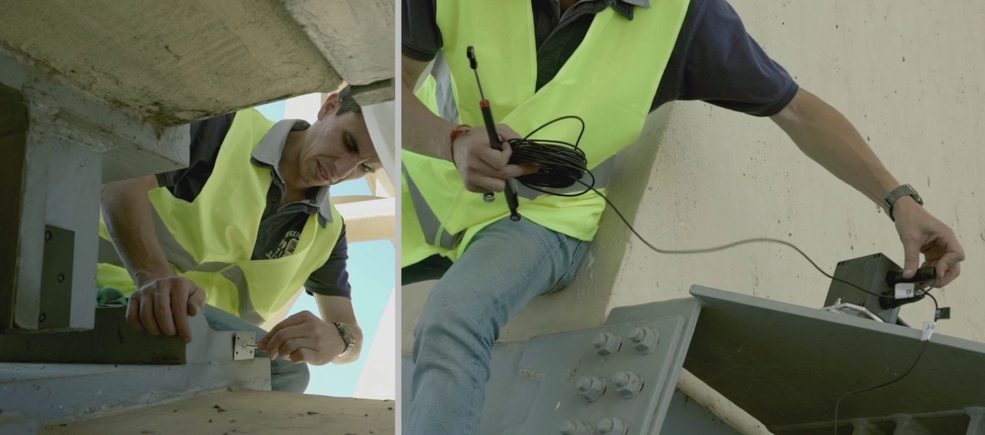
Tiago Dias of Matereo installing sensors and gateway in the Trancão Bridge. Credit: Brisa
“To properly monitor a bridge, you need to integrate data from different sources,” says Vieira. “With sensors you can take measurements with a sub-millimeter accuracy, and with that you can assess the state of the structure, which is not possible with any other technique. But combined with InSAR, we can measure vertical and horizontal displacements of the infrastructure totally and remotely. That is a very powerful tool, especially when the location of interest, a bridge for example, is not very accessible.”
Vieira, of course, is referring to Interferometric Synthetic Aperture Radar technology. InSAR is a space-borne monitoring technique that can detect deformations on the ground surface using radar energy. Unlike other remote sensing platforms that rely on visible or infrared light, radar waves emitted from orbiting InSAR satellites can penetrate clouds and collect data in darkness, allowing for relentless monitoring of infrastructures in all-weather conditions.
InSAR also broadens the ability of engineers to monitor infrastructures that are spread over an extensive area. Currently orbiting satellites that have InSAR capabilities have swath widths of less than 40 to more than 250 km (25 to 155 miles). Their revisit times can vary from 12 to more than 45 days, although some critical areas are monitored every six days. This cycle allows for consistent periodic assessments to be done at a great scale.
“With only one InSAR image, you can monitor multiple assets at the same time. So, if you are an asset owner and you have a lot of infrastructures to monitor, you can use InSAR to make the first assessment in a large-scale monitoring. After that, you can define where to start and to prioritize your in-depth monitoring using sensors or other techniques in specific infrastructures,” says Vieira.
As a civil engineer who has worked for a construction management company in Africa, Vieira knows what he is talking about. Backed by years of experience building hundreds of metallic bridges around Angola, he moved to Portugal in 2014 and started Matereo, a name brilliantly coined from combining the words material and rheology (or reologia in Portuguese), the study of the flow of matter.
“We built the company to bring space technologies to civil engineering applications. That was the start,” says Vieira. “But then in May 2018, I had a meeting with Brisa, the main private roadway operator in Portugal, and they were very interested to test our sensor-based monitoring solution in one of their bridges. From that moment we started to work deeply on the development of Matereo.”
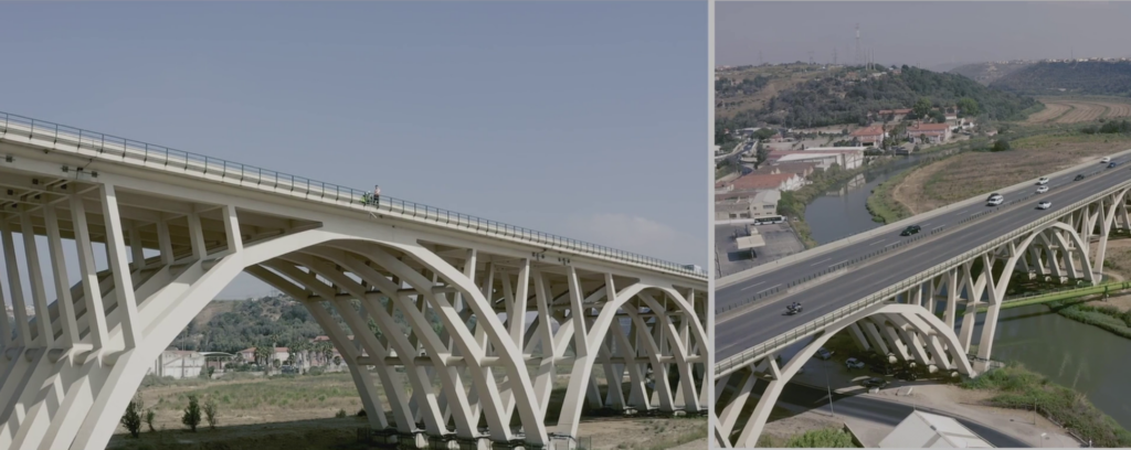
The Trancão Viaduct in Lisbon, Portugal. Image: Brisa
That bridge is the Trancão Viaduct, a critical asset for Brisa. Located in the capital of Lisbon, the viaduct is one of the main highways of the country with some 86,000 vehicles passing over it daily. Matereo is currently providing their wireless sensor monitoring solution to examine the bridge’s structure.
Built in 1959 over the Trancão River, the 329-meter (1,080 feet) bridge is made entirely of reinforced concrete. It consists of five spans formed by six individual arches, forming a deck with a width of 30 meters (98 feet). The spans are separated by expansion joints, each of which moves in an independent dynamic behavior to stabilize the bridge during an earthquake.
A recent intervention carried out by Brisa on the viaduct consisted of improving its seismic action performance. To achieve that, the company’s engineers introduced an isolation and seismic dampening system at the base level of the arches. And then, complementary to this, they also established the continuity of the deck at the level of the expansion joints.
“With a small budget, Brisa asked us to do a pilot test on the Trancão Viaduct. They were interested in the sub-millimeter movements of the new work that they did in the base of the arches and expansion joints,” says Vieira. “We had to develop cost-effective solutions that can provide highly reliable results.”
Vieira and his team then installed a set of wireless sensors in different parts of the viaduct to collect structural information. After three months of successful pilot testing, they used intricate statistical models to extract more value from the acquired data.
“The results of the analysis have allowed us to have the crucial information needed to assess if the bridge and its seismic reinforcements are behaving correctly,” he adds.
With the preliminary lessons learned from the Trancão Viaduct project, they then applied the same approach to another bridge, this time located in South America. They paired their fully tested automatic sensor technology with satellite data from InSAR.
“I am very proud of the Paso Real bridge monitoring we are doing in Colombia,” says Vieira. “This is a completely different bridge from that of Trancão because it is a slender metallic cable-stayed bridge, meaning that it moves a lot.”
Matereo is currently analyzing the vibrations of the bridge and implementing techniques for damage detection. “We are using InSAR in this case to identify abnormal ground movements, which can put some stress on the bridge. Then the sensors are there to monitor the structural behavior and to work on damage detection,” says Vieira.
The Paso Real bridge in Colombia. Image: Matereo
Passing over the Cauca River in Santa Fé de Antioquia in Colombia, the ochre-colored Paso Real bridge was built in 1965 to link the city of Medellín to the western part of the country. The 426-meter (1,397 feet) span crosses the river at a height of 16 meters (52 feet).
“The Paso Real bridge is constantly being monitored with inclinometers, optical displacement sensors, vibration sensors, and InSAR measurements,” says Vieira. “All this data are then sent and analyzed in the Matereo web platform.”
“Because the Paso Real bridge is too small, it is not wide enough to get good quality satellite radar data to monitor the bridge’s deck. But despite the limitations of the radar resolution, we can still use it to monitor the ground movement around the bridge. This is also very valuable,” says Vieira.
Matereo then provides the local managers of the bridge an InSAR dashboard that facilitates the visualization of data and their interpretation.
“We are talking about different levels of monitoring here,” explains Vieira. “It’s like when you go to the doctor to check your heart. The doctor first listens to it, then he can do an electrocardiogram. If he notices some abnormal trend, he can move for in-depth monitoring and diagnosis technique. It is the same approach when we are monitoring critical infrastructures like bridges. We have to analyze trends at different levels to be able to detect damages.”
The technology behind Matereo can be used to monitor different types of infrastructures, not just bridges. They also have projects watching over railway structures in Portugal and Brazil.
“Buildings, tunnels, bridges; depending on the component to monitor and the concerns of the asset owner, we start by advising which solution can fit their needs,” explains Vieira. “That can be with InSAR only, sensors only, or a combination of both. We always look for the better technical and economical solution for each case.”
It Will Cost the Earth
Working on various projects has taught Vieira that the price of acquiring high-resolution InSAR data can be a drawback for many bridge operators, especially when it comes to choosing a combination of sensor and radar imagery for bridge monitoring.
“For me, the only disadvantage right now is the cost of high-resolution radar images,” says Vieira. “But that should lower with more competitors and data providers. Despite the limitations regarding resolution and frequency of publicly available InSAR from Sentinel-1 satellite, it is still a valuable solution for many use cases.”
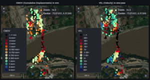
Monitoring the Paso Real Bridge using the Matereo’s InSAR Dashboard.
The satellites that Vieira is referring to are the Sentinels 1A and 1B (the latter retired last year). They are both operated by the European Space Agency (ESA), and thus their radar data is free for public use. With a spatial resolution of five to 40 meters and a repeat cycle of 12 days, it is the go-to imagery for most structural monitoring projects. Other Earth-Observation orbiters that have better InSAR resolutions, such as the COSMO-SkyMed, ICE-EYE, and the ALOS, are geared toward defense and commercial uses, thus they can be quite pricey for small bridge operators.
Yet once accessible, these commercial InSAR images can be very useful. For example, Vieira cites how a study by the National Aeronautics and Space Administration (NASA), spotted the structural problems that beset the Morandi Bridge before it collapsed, although belatedly. The authors of that research used archived InSAR imagery from the COSMO-SkyMed satellite.
“NASA has done a study using InSAR on the Morandi bridge, and they identified some abnormal trends based on the historical imagery data. That could have suggested a damage on the bridge, and with further in-depth analysis, perhaps may have avoided casualties,” explains Vieira. “If you think about the human and material losses due to the accident in Morandi, high-resolution InSAR doesn’t seem that expensive.”
That is why Vieira thinks that there’s a need for space agencies to foster and step up the use of InSAR satellites, especially when it leads to improving public safety through better civil engineering.
“I believe that programs like what the ESA is promoting, which are funding new projects and companies that uses Earth Observation data, are playing a crucial role in staging the use of satellites in different sectors,” says Vieira. “For example, civil engineering is still a very traditional segment, at least here in Portugal. But I believe that this will change fast.”
To achieve that change, Vieira considers it important to support new businesses that use satellites in this field. But he also reckons that it will take a lot of work to persuade potential customers on the advantages of Earth-Observation technologies, such as InSAR.
“You need to talk with a lot of people to convince them about the benefits of new solutions. There is no better way to promote innovation,” says Vieira.
Perhaps businesses like Matereo will just have to wait until 2024, when the much-awaited NISAR, a joint Earth-observing mission between NASA and the Indian Space Research Organization (ISRO), will be launched to service. NISAR’s powerful worldwide radar coverage will surely add to our arsenal of tools that will support public safety. It will also be free and open to the public, lowering costs.
Notwithstanding the challenges behind the use of InSAR and other satellite payload technologies, making radar data easy cheap and accessible will surely make it more popular. And it certainly does not need a nursery song to promote its use.