Tag Archives: Teledyne Optech
CZMIL SuperNova is Changing Bathymetric Lidar
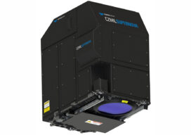
CZMIL SuperNova, Teledyne Optech’s next generation bathymetric lidar system, is changing the way information about coastal territory is collected and processed. Terratec AS, a leading Norwegian mapping firm, is the first private company to acquire the CZMIL SuperNova and the only company in the EU to engage in work around environmental change and coastal zone mapping...

Weekly xyHt News Links: 05/18/2018
Carlson PhotoCapture to be presented at GEO Business 2018 Teledyne Optech displays its advanced lidar solutions at GEO Business 2018 Marine-i event will help to chart a future course for the marine industry Bentley Systems, Inc. to Present Reality Modelling for Digital Cities at GEO Business Event in London Carlson Software Unveils Carlson PhotoCapture
xyHt Weekly News Links: 9/29/17
Teledyne Optech and IGI announce new cooperative agreement and first product offering Hemisphere GNSS Debuts Next-Generation S321+ and C321+ GNSS Smart Antennas Septentrio unveils the new Altus NR3 at InterGEO GeoSLAM Launching Enhanced SLAM Software and Next Generation Mobile Scanner at InterGEO 2017 INTERGEO 2017 Berlin: Geo-IT-event officially opened Applanix Announces POSPac Cloud for Mobile Mapping...

Tech Feats for a X-Country Course
A 3D data company created a photo-realistic cross-country-course simulation using mobile mapping, with more innovation to come. When the best collegiate runners take their marks at the NCAA Cross Country Championships in Wisconsin next year, the course will be as familiar as their favorite training routes. Above: Plans are underway to create treadmill routines that match the...
xyHt News Links: 10/21/16
Teledyne Optech announces new efficiency enhancement for ALTM™ Galaxy wide-area lidar mapping sensor Canon Launches the Océ PlotWave 550 Print System Designed to Greatly Enhance Large Format Technical Document Management AVEVA and AEGEX partner to deliver Digital Asset solutions in Hazardous Environments Rwanda Launches World’s First National Drone Delivery Service Powered by Zipline UAV Drones...
xyHt News Links: 5/20/16
Teledyne Optech and GeoShack sign North American distribution agreement CHC launches high-end GNSS receiver for science, surveying HP Delivers World’s First Production-Ready 3D Printing System COPTRZ™ Launch: Changing The Face Of Construction With Drones Optech Eclipse to be introduced to international audiences at GEO Business UK Esri introduces high-precision GNSS mobile GIS software