Tag Archives: uas
Your sUAS Un-checklist
We’re all familiar with the concept of checklists: handy organizational tools for getting things done. As business persons, you should also be familiar with the concept of “barriers to entry”: the greater the obstacles, the more difficult it is for a business to enter a market, and vice versa. And unless you’ve beaten Elon Musk...

xyHt News Links: 7/8/16
Reduction of the Nationwide Differential Global Positioning System (NDGPS) FAA to Answer UAS Rule Questions at MAPPS Summer Conference Trimble R2 GNSS Receiver Now Available for Data Collection Trimble Adds Fully Automated Scheduling Capabilities to its Advanced Solution for Field Service Management Dewberry completes US hydrography study for business uses, requirements
UAS & The Combo that Opens Access
The most logical integration of technologies for surveyors is combining 3D laser scanning with UAVs. It’s no secret that many geospatial professionals are enamored with unmanned aerial systems (UAS). For many years, the pros and cons of deploying small UAS for mapping and surveying, along with their ongoing regulatory discussions, have been well researched and...

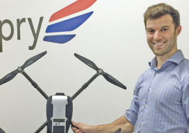
senseFly’s Andrea Halter: From Academia to the Market
Above: This eBee Ag is outfitted with the Sequoia multispectral sensor. An interview with senseFly’s Andrea Halter Andrea Halter is a co-founder of senseFly, a Parrot company based in Switzerland that develops and produces aerial imaging drones for professional applications. Halter oversees the company’s marketing and sales teams. She’s a qualified land surveyor and holds a...
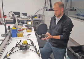
Kespry: Anatomy of a UAV Start-Up
Above: CEO and founder Paul Doersch, a Stanford alum, explains Kespry’s unique rental/cloud arrangement. Kespry offers much more than a bird’s eye view. Take a computer scientist from Stanford University (who’s worked in Silicon Valley doing research for BMW on self-driving cars and smartphone integration) and add some grads from MIT and Cal Tech (with...
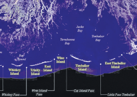
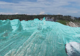
Crossing the Barrier
Above: The Barrier Islands off the Gulf Coast are threatened by coastal land loss. A Louisiana university overcame a barrier facing scientific research of coastal land loss—with a UAS. “We are losing an acre of coastline every 30 minutes,” says Dr. Gary LaFleur Jr., associate professor of biological sciences at Nicholls State University in Louisiana. And...