Tag Archives: uas

Surrogate UAS
Above: Hart Drobish, president of Courtney Aviation, was a contractor to the forest service flying the air tactical control platforms on the Happy Camp Complex wildfire. Additionally, Drobish served as a ground liaison contact on the project, managing the flow of infrared and visual imagery from the aircraft to the end users. Combining UAV technology...

Legal UAS
Until the final FAA rules are in place for UAS incorporation in national airspace, the Section 333 exemption petition process is the only way to legally fly UAS for commercial applications in the United States. In late 2014, Government Accounting Office (GAO) stated, “The consensus of opinion is the integration of unmanned systems will likely...

UAVs for the Whole World
UAVs are fundamentally changing our world. From use in conservation, humanitarian relief efforts, precision agriculture, and a myriad of other commercial applications, more people are realizing the benefits UAVs can bring for changing businesses for the better and saving and improving people’s lives. A growing diversity of markets and applications are creating substantial opportunities for...
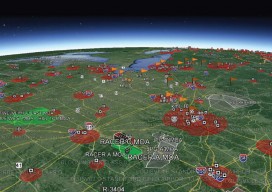
COAs from an Operational Applicant’s Perspective
Above picture: As COAs cross different airspace types, more coordination is required for the FAA to allows safe UAS operations in the National Airspace. By now, most everyone reading this has at least some understanding of the potential benefits an unmanned aircraft system (UAS) has on their industry. I have read publications that mention that precision...

All Over the Map
The regulations and uses of UAVs for mapping in Latin America are as diverse as those cultures, but their drivers are much the same as we see here in the United States. Using manned airplanes for aerial photography and photogrammetry is an especially expensive proposition for countries south of the Rio Grande. The reasons are...

Aerial Imaging in Antarctica
It was quite an adventure: an all-or-nothing mission to map a research station in Antarctica. Like numerous countries around the world, Ecuador’s mapping agency, Instituto Geografico Militar (National Military Geographic Institute of Ecuador or IGM), is a technical institution within the country’s military establishment. The IGM is responsible for developing the national mapping and the geographic...