Tag Archives: uav
ROPOS: ROV Cool
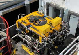
I recently accompanied a film crew working on a documentary on maritime technologies to the NOAA facility in Newport, Oregon to catch a glimpse of what is widely celebrated as the “coolest ROV in the world.” The Remotely Operated Platform for Ocean Sciences (ROPOS) is the flagship research ROV of the Canadian Scientific Submersible Facility...
All Over the Map
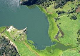
The regulations and uses of UAVs for mapping in Latin America are as diverse as those cultures, but their drivers are much the same as we see here in the United States. Using manned airplanes for aerial photography and photogrammetry is an especially expensive proposition for countries south of the Rio Grande. The reasons are...
Aerial Imaging in Antarctica
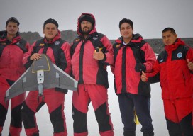
It was quite an adventure: an all-or-nothing mission to map a research station in Antarctica. Like numerous countries around the world, Ecuador’s mapping agency, Instituto Geografico Militar (National Military Geographic Institute of Ecuador or IGM), is a technical institution within the country’s military establishment. The IGM is responsible for developing the national mapping and the geographic...
UAV News: Recent Court Cases
Here are two recent court cases involving the Federal Aviation Administration (FAA) andusers of unmanned aerial vehicles (UAV). In both cases, the FAA’s position that their 2007 policy memorandum on UAVs, particularly in regard to their being used for commercial purposes, was found to be not legally binding. Rafael Pirker v. FAA In this court case,...