Tag Archives: uav

xyHt News Links: 1/29/16
SAM Announces Leadership Promotions OGC announces Arctic Spatial Data Infrastructure Project Topcon to feature mobile solutions center at World of Concrete Major Update of RIEGL’s Terrestrial Laser Scanning Software Suite Now Available Bluesky Boosts Drone Survey Offering with Cyberhawk Partnership FAA hits 3,000 exemptions, 300,000 registrations for UAVs Advanced Navigation releases GNSS/INS post-processing software Eos...

Robot Revolution
Clearpath Robotics CEO Matt Rendall discusses unmanned systems, land survey, and robotic industry trends. The robot revolution is hitting a big milestone. Robotic use is expanding beyond research activities, aerial applications, and industrial manipulators through a new kind of deployment: the service robot. These robots are autonomous, they’re geospatially aware, and they can manipulate...
UAS Coalitions
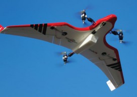
Above: Hybrid multirotors such as the FireFly 6 are offering solutions to common problems, allowing automated takeoff and landing along with waypoint flight control. Credit: Jon Barnes, Bajora Media. What are they doing for the UAS industry? Being an entrepreneur is a lot like being a surfer. You need a surfboard and access to...

Surrogate UAS
Above: Hart Drobish, president of Courtney Aviation, was a contractor to the forest service flying the air tactical control platforms on the Happy Camp Complex wildfire. Additionally, Drobish served as a ground liaison contact on the project, managing the flow of infrared and visual imagery from the aircraft to the end users. Combining UAV technology...
SGM
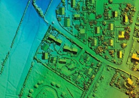
Obtaining economical and accurate point clouds from semi-global matching. In the old days, mappers were thrilled with 30 meter USGS digital elevation models (DEMs). These were available for almost everywhere in the United States. Years later they started producing 10m DEMs, and life was really good. We had one elevation point “on the ground” every...
COAs from an Operational Applicant’s Perspective
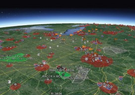
Above picture: As COAs cross different airspace types, more coordination is required for the FAA to allows safe UAS operations in the National Airspace. By now, most everyone reading this has at least some understanding of the potential benefits an unmanned aircraft system (UAS) has on their industry. I have read publications that mention that precision...