Tag Archives: Verisk
Vexcel Imaging to Acquire Image Survey Expertise and Data Assets from Verisk to Support New Strategic Partnership
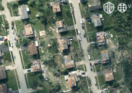
Combination will create the world’s highest-quality and most comprehensive geospatial image and data library JERSEY CITY, N.J., and BOULDER, Colo., January 21, 2020 — Vexcel Imaging, a leader in aerial imagery data, large-format aerial cameras, and photogrammetry software, today signed a definitive agreement to acquire the imagery sourcing group from Verisk’s Geomni business. The acquisition...

Aerial Self-sufficiency
Above: Universal Studios, Florida A large risk-assessment and data-analytics company created its own internal system to collect imagery, write software, and develop processing workflows. If a private company or public agency is large enough, it may be able to internalize all of the processes for its services rather than having to outsource any. For example, it might...

GEO Business 2018: “Geocoolness” in the London Heat
Trends in geomatics tech and spatial IT at the UK’s premier annual geo conference and exhibition Editor’s Note: GEO Business is an annual conference held annually in London. xyHt’s Europe editor, Nick Duggan has been attending each year, chronicling trends in the geo industry. The event is growing into one of the premier geo events...

xyHt Weekly News Links: 8/4/17
Dewberry Honored for Special Achievement in GIS Reps. Westerman and Moulton Introduce Bipartisan Geospatial Data Act | Congressman Bruce Westerman GeoCue Announces GNSS Direct Geopositioning System for Low Cost DJI Drones Nearmap Provides High-Rez Oblique Imagery and 3D Products in Ready-to-Use Service ILMF Call for Papers Deadline is August 14! Congressman Doug Lamborn Addresses MAPPS...