Tag Archives: Yellowscan

xyHt Weekly News Recap: 02/09/2024
Bluesky Aerial Photos at Heart of New Met Police Mapping Tool Hyperspectral Insights to Understanding the Earth Digital Construction Week Set for June in London TCarta Plans Bathymetric Mapping Workshop for Jamaica Canadian Hydrographic Conference Set for May in Newfoundland YellowScan Launches Bathymetric Lidar System Techtree Unveils ‘AROUND,’ A New Era in Geospatial 3D Visualization ...
xyHt Weekly News Recap: 01/26/2024
TopGIS Elevated 3D Visualization Capabilities with UltraCam Osprey 4.1 Esri Launches Maps.com, a Content Platform for Creators Demonstrating the Power of Maps ComNav Launches New P6H Handheld for GIS: A Blend of Enhanced Precision and Superior Portability Lidar Reveals 2,500-Year–Old Cities Hidden in the Amazon Techtree Innovation Launches 3D Geospatial Map Platform Commercial UAV Expo...
xyHt Weekly News Recap: 09/10/2021
Hesai, LiDAR USA Reach Distribution Agreement Propeller Aero, Named 2021 Best Workplace for Innovators National Academies Proposes Team to Study FCC Ligado Decision NOAA Awards Tetra Tech $49 Million Coastal Geospatial Contract Velaris Connectivity Solution Unlocks Possibilities in UAV Industry GEOINT 2021 Symposium Oct. 5-8 in St. Louis Woolpert Acquires Optimal GEO to Augment Lidar,...
Weekly News Links: 10/30/2020
See the New Riegl VUX-120 Lidar Sensor YellowScan Launches Updated Mapper Product MGISS Helps Urban Surveyors with Ultimate Accuracy The Future of LiDAR is Critical to the Future of Our World China Experiencing a Drone ‘Revolution’ in Agriculture The Dashcam Built for Mapmaking Swift Navigation’s Production-Grade SSR Service is Now Available Across Two Continents
Geo Week 2019: Lots and Lots of Lidar
Every time I go to this conference I get the sensation of drinking from a fire hose: so much lidar technology! This year the International LiDAR Mapping Forum (ILMF) became Geo Week with the addition of the ASPRS annual conference and MAPPS winter conference. Here’s a small sample of the wide array of lidar tech...
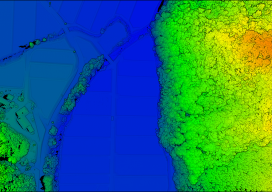
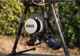
Standalone UAV Lidar
Above: The YellowScan Vx-20 collected this image in Hiroshima, Japan in May 2018. A surveying company developed a self-contained UAV lidar system so teams could gather data without a lidar specialist. Some companies are born (and some are transformed) when their founders switch their focus from using a tool for projects to developing that tool...