Australia tech-rebel company Locata is poised to profoundly change the world of positioning, navigation, and timing.
In 1994 in Canberra, Australia, accomplished musician and entrepreneur Nunzio Gambale was introduced to a fellow musician, David Small, by Gambale’s cousin who had been giving Small a hand with an interesting experiment. This chance meeting began an amazing partnership in technological development.
The scenic capital territory of Australia has its fair share of domestic and international tourists; Dave Small’s experiment was testing the use of GPS to help trigger commentary and information on devices tourists could carry to help guide them around the stately parkways and museums. This was long before smartphone navigation—it was a novel idea at the time. As is the habit of this particular duo, they quickly identified a problem they knew just had to be “fixed”: tourists would definitely want to go inside where GPS did not work.
This realization was the first of the many holes in the Swiss cheese of GPS that Gambale likes to point out. It is not so much that Locata paints GPS/GNSS as “bad” or obsolete for what it was originally designed to do. The more the duo used and understood GPS the more they understood that satellite-based systems alone could never deliver on all future expectations. There were more than enough holes to warrant augmentation, supplementation, and development of completely new alternatives.
“Dave is one of the most fearless people in the world,” says Gambale. “There is not a single technical challenge he will not take on.” Imagine someone asking you to locally replicate GPS, without atomic clocks, satellites, or the mega-budget of a superpower nation. And it has to be affordable enough for any size company to deploy.
Small, the chief inventor at Locata, with his background in ham radio, music, broadcast television, and recording, has an innate sense of the nature of waveforms and signals. Plus being an insatiable tinkerer with various radios, electronics, instruments, and sound systems, Small was up for any challenge. While talking to Small and Gambale I got the sense that they would go as far as splitting atoms to solve engineering conundrums.
History is full of inventors and non-traditional scientists who tinkered their way to success. Arguably, the most profound innovation in navigation was the solving of longitude and the work of the 18th century clockmaker John Harrison. Gregor Mendel, DaVinci, Franklin, Bell, Edison, Nikola Tesla, and many more were consummate tinkerers. Then there was the bicycle-mechanic siblings who stood on the sand dune in North Carolina a century ago launching humankind into the heavens.
The way GPS/GNSS works, Small and Gambale determined, would be perfectly sound for original goals, but for future mobile applications they had to improve what it could do. Indoor location is one thing; there are a many indoor navigation approaches: emitted RF ranging, pulsed signals from lights, photogrammetry, sonic imaging, WiFi ranging, and more. These “alternate technologies” were never designed for high-precision positioning.
What Small and Gambale had in mind was much more reliable, higher-precision indoor positioning: elegantly extending GPS, relaying, repeating, emulating, or imitating what GPS can do—but indoors and anywhere else needed. There was period of re-examining the fundamentals of how GPS works, and they soon understood that the key to everything was in time and time synchronization.
Timing Really Is Everything
NEARLY EVERY PROFOUND innovation in positioning and navigation since the days of Harrison’s nautical clock (his H5 Chronometer is shown below) has relied on some element of time: sonar, radar, laser-ranging and RF-based EDMs, LORAN, ADSB, et al., and GPS/GNSS. Many solutions are variations on the same themes of ranging, rays, or beams where required synchronization levels are extremely tight. Radio signals travel at the speed of light; there is little margin for error.
It was the Doppler effect of the very first Sputnik, tracked by Johns Hopkins University, that confirmed the global navigation system’s theories of scientists and visionaries like Arthur C. Clarke. The first global navigation test system by the U.S. was aptly dubbed the “Timation” system, with the Doppler-based Transit system following in the early 1970s. GPS would put all of these elements together: atomic clocks, synchronized time (within 20-30 nanoseconds), tracked orbits—enabling code and carrier ranging.
Speed-of-light signals are perfect in a vacuum, but on the ground one has to consider delays in signals from the ionosphere and troposphere. And then there is the warping of space-time itself. That fellow Einstein was right: time will vary between two observers in locations of varied gravity and orbit. GPS satellites are around 20,000km out; at that reduced gravity their atomic clocks run about 38 nanoseconds apparently faster than an identical clock on the ground. Without the time dilation being taken into account and without satellite clock offsets being constantly tracked and updated, GPS positions would go out of useable range in a short span of time.
Globally we rely heavily on satellite and atomic clock-based global timing. The global timing capabilities delivered by GPS/GNSS are used by far more people and applications than for positioning and navigation, by orders of magnitude. Network computing and telecommunications have evolved into the magic we take for granted only by leveraging this time element. Achieving extraordinary levels of time synchronization without atomic clocks—that is the revolution in timing that Locata has ignited.
Bringing Time Synchronization Down to Earth
The Locata founders decided to take a look at just how far they could advance the timing aspect of positioning. It was not entirely a new undertaking; nearly half a century earlier at the Naval Research Laboratory near Washington, D.C., scientists set up a network of atomic clocks, ground transmitters, and receivers to test what would become of the Timation satellite navigation experiment. Locata’s approach was to have components synchronize like instruments in a band. Results were unprecedented.
On the surface, a LocataLite transmitter works just like a GPS satellite, sending code and carrier, and the LocataLite “slaves” do the very same thing, creating a network of positioning signals. The key to the system and its incredibly precise relative positions (and time) is the local synchronization of time. Locata calls this their “TimeLoc” technology, enabled by a heavily patented synchronization methodology called Time Lock Loop (TLL).
Whereas GPS/GNSS relies on global time synchronization via many atomic clocks, tracking networks, updates, offsets, continual monitoring, and adjustment, a network of any number of LocataLites can, within moments of being turned on, achieve local, synchronized time in the range of a few nanoseconds and picoseconds (see “Picoseconds,” below).
Small’s initial spark of invention was sound; Locata could be developed to work indoors, outdoors, in sky-view-challenged areas, and even potentially in GPS-compromised battlefield scenarios. Now it was time to productize. Small and Gambale understood that their solution was not only real-time-survey-grade for positioning where GPS did not work, but also a scientific-grade timing solution.
Gambale was already a pioneering businessman. In the early 1980s when others in the music industry brushed off his idea of sending mail-order catalogs for musical instruments to the farthest reaches of Australia, every “you’re crazy, mate!” steeled his resolve, and he grew his startup, Pro Audio Supplies, into a multimillion dollar enterprise— which he could now sell to help fund development of Locata solutions. The pair started to challenge traditional precision positioning and timing markets, and those markets have taken notice.
Real-time centimeter positioning in places where GPS/GNSS can’t reach represents substantial market potential. Think of precision guidance for machine automation and large-scale metrology for manufacturing on huge indoor factory floors or for construction of buildings and major structures, shipyards, warehouses, and port facilities. The Locata solution has certain advantages beyond just working in places where the satellites are not in view; it works at much higher power ranges and can be deployed to work at completely different frequencies making it more immune to jamming and interference.
GPS/GNSS downtime can be critically important for safety-of-life uses and quite costly for commercial activities. In a huge mining operation, for instance, a loss of high-accuracy machine control can cost the miner tens of thousands of dollars per hour. Leica Geosystems recognized this and sought Locata as a development partner for a hybrid solution their customers urgently desired (see “Eliminating Downtime,” page 17).
Picoseconds
Locata has developed a close relationship with the University of New South Wales (UNSW), that’s independently examined many aspects of Locata technology, including real-world use-case tests. One test involved setting up a LocataNet around central Sydney Harbor, with UNSW students testing Locata’s positioning capabilities, both indoors and outdoors.
However, it was a 2013 synchronization project and academic paper that caught the attention of the international scientific timing community. An array of LocataLites was installed on towers in the Snowy Mountains of New South Wales at distances of 45km and 28km respectively, a total range of 73km specifically for time transfer tests. This closed system repeatedly yielded differences between the pulse-per-second signals of co-located GPS in the order of mean deviations of a few nanoseconds and a few hundred picoseconds standard deviation.
The only other way to achieve such precise time transfer would be lasers and fiber optics, not always practical or affordable. A truly broadcast-signal-based system of this accuracy would have far-reaching utility, opening whole new fields of innovation in telecommunications, distributed computing, navigation, guidance—and a much-needed backup and alternative to GPS/GNSS for timing of critical systems.
The conference paper on the tests, by UNSW’s Rizzos, Glennon, and Dempster, was presented by co-author Joseph Gauthier at the U.S. Institute of Navigation’s Precise Time and Time Interval Conference held in Seattle in December 2013. Gauthier noted that Locata allowed tropospheric conditions to be taken into account. The researchers could observe miniscule variations of the speed-of-light signals. “It was great that any biases we saw could be completely accounted for,” said Gauthier. Results have inspired the planning of synchronization trials in several major cities.
What Clock Tests the Test Clocks?
THE U.S. GPS NAVSTAR constellation of satellites was funded and developed by a military program but has ironically provided tangible
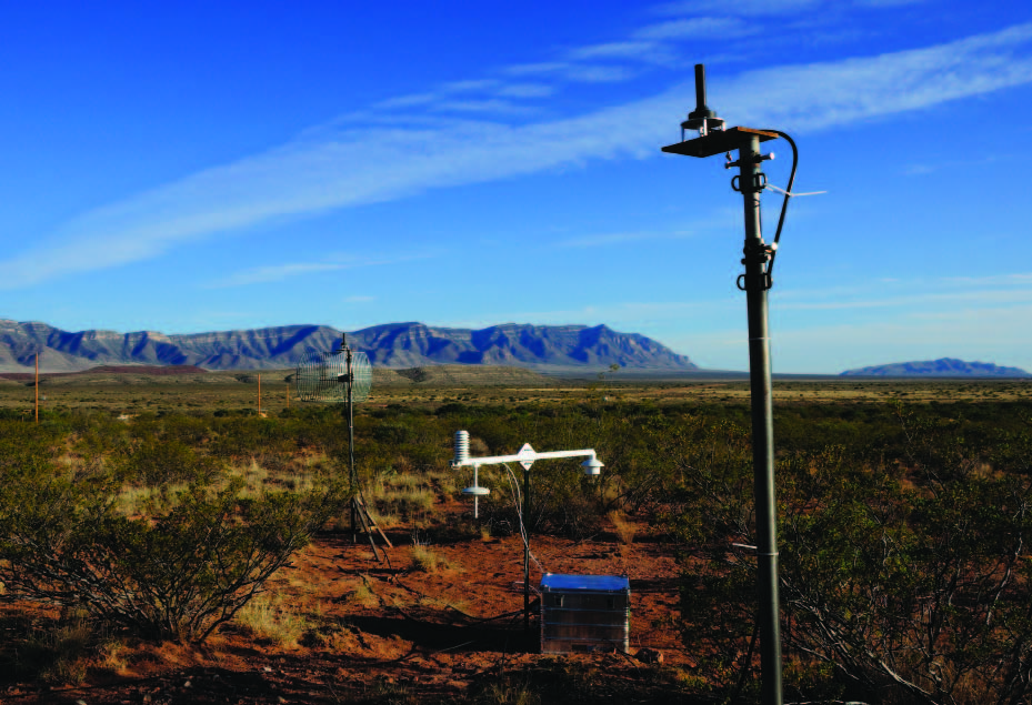
LocataLite deployed at the site of initial tests for the USAF at the White Sands missile range in New Mexico.
commercial, scientific, and even consumer benefits hundreds if not thousands of times greater than the original investment. Defense also considers non- GPS systems to mitigate battle space GPS-compromised environments (considerations rightly for safety-of-life and critical functions in the civilian sector as well … but more about that later).
The USAF developed the Ultra High Accuracy Reference System (UHARS). This system is, by design, the world’s best non-GPS benchmark for testing navigation. The USAF’s Central Inertial and GPS Test Facility at Holloman Air Force Base in New Mexico played a key role in the initial development of GPS and is now charged with getting the UHARS up, tested, and deployed. They contracted with Locata to use its LocataNet and TimeLoc solutions as core-enabling technology, allowing the UHARS to serve as the time and ranging “truth” for future GPS testing.
A LocataNet (or array of synchronized LocataLites) was first trialed by the USAF at the White Sands Missile Range. The USAF reported exceptional results for terrestrial and airborne tests over thousands of square kilometers—beyond expectations. Over many days of testing, Locata’s non-GPS solution could position an aircraft traveling at ~400 mph, at a range of over 35 miles, to a few inches’ precision in real-time. Locata is the key component for the new “truth system” for the testing of future navigation systems for the U.S. Department of Defense.
GPS 2.0
Locata components are small, easy to deploy, and quick to get synchronized. Gambale likes to characterize a LocataNet as “your own GPS” or “your personal constellation”; he has even trademarked “GPS 2.0” to emphasize the potential future impact of such technologies on the evolution of radio-based positioning solutions.
The original motivation for development was lack of outdoor/indoor transition options at the time. Fast forward to the present day when Locata systems are hitting multiple early-stage markets, and Locata can rightly tout one of the most precise, if not the most precise, non-laser indoor positioning solutions.
Other indoor navigation and location-based services are happy with low precision, but there are very real needs for centimeter-accurate indoor positioning services, especially on moving objects. One such implementation is at a world-renowned vehicle crash test facility (see “Flat Robot” at the right).
Note that Locata is not being touted as a solve-everything alternative to GPS/GNSS or that it in any way could completely replace GPS/ GNSS, the nickname of “GPS 2.0” notwithstanding. There are so many significant merits to and proven applications for Locata solutions as to warrant very little spin. If I might take exception to some of what supporters of GPS/ GNSS alternate solutions like Locata have, in some cases, promoted as an unfortunate “us-vs.- them” stance: pointing out where other systems cannot work is secondary to showcasing how Locata’s solution can fill in, supplement, and even improve what GPS/GNSS and other navigation, timing, and positioning systems do.
There are certain situations where Locata could not completely replace current global systems but could end up improving them. Locata could not (at present) work across oceans or even country-sized terrestrial regions (not without massive infrastructure investments). A lot of multi-use combined implementations have been envisioned because Locata networks can be scaled from the size of a room to thousands of square miles. For example, a highway corridor could be lined with a LocataNet and serve not only positioning and navigation but also as a time-transfer backbone. Entire cities could have dense networks by installing LocataLites on cell towers, providing resilient seamless indoor and outdoor positioning.
Nevertheless, Locata signals are still susceptible to the very same physics that degrade GPS/ GNSS and other legacy systems, like multipath. Radio signals bounce off obstacles and objects in cluttered environments like cityscapes, and the resultant multipath creates havoc for accurate radio positioning. Small and Gambale knew they would have to eventually have to face the multipath devil (see “VRay,” below).
Eliminating Downtime
“This was the first [system] we have ever deployed which completely exceeded our expectations,” said John Carr, fleet management
A Jigsaw system (hybrid Locata & GNSS solution by Leica Geosystems) was set up on the rim of the Boddington Mine in Western Australia, providing precise real-time positioning for drilling rigs on the mine floor.
specialist at the Boddington Gold Mine in Western Australia. The system Carr is referring to is a mix of positioning technologies that is sold by Leica Geosystems as the Jigsaw Positioning System (JPS). Initially developed for the mining market, the full system consists of a network of LocataLite “beacons” on the rim of the open pits. Leica Geosystems’ JPS receivers are a combined GNSS receiver board and a Locata receiver board using LocataLite signals interchangeably with satellite signals.
Carr first installed the Jigsaw receivers and antennas on the drilling rigs that constantly crisscross the open mine, drilling precise holes (within an inch) for blasting as the floor of the mine drops from the current depth of 300 meters to a planned future depth of over 900 meters. The problem, of course, is that as the mine gets deeper, fewer and fewer satellites are in view. GPS/ GNSS solutions deteriorate further as the depth increases.
“The JPS,” explains Frank Takac, chief engineer and head of R&D GNSS Position Engineering with Leica Geosystems, “incorporates the available GNSS signals into the solution, thus adding some high elevation signals to improve the overall geometry of the ground network. To achieve this integration, we estimate all of the unknowns between GNSS and the Locata system in a tightly coupled solution.”
Carr has been thrilled with the results and how easy it was to deploy. “We set up the LocataLites on the rim, using solar panels for power,” he said. “Once we turned it on the whole network synchronized right away, and we could simply start using it. Downtime in the mine can be quite costly, and as for the drilling rigs with Jigsaw deployed, any downtime since then has not been due to the navigation system.”
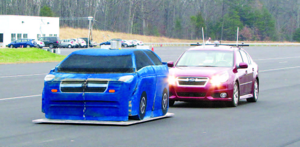
Flat Robot
One recent clear morning in rural Virginia I witnessed a car applying the brakes to avoid hitting a slower-moving car ahead: a commonplace event except that car had no driver, nor did the “target” car. These were test vehicles at the famed Insurance Institute for Highway Safety (IIHS) research facility in Ruckersville, Virginia, and they were solely guided by Locata.
Historically, controlled crash tests involved vehicles guided along tracks for head-on, side, or rear collision tests, revealing how safety features like airbags and seatbelts performed. Now the emphasis is crash avoidance systems, automated hazard detection, and braking: options available on many new vehicles like the camera-based system tested on a new Subaru that day. The only truly meaningful tests have to be done on freely travelling vehicles in real-world conditions. Robotics provides the answer.
Dr. Paul Perrone and his team from Perrone Robotics, leaders in providing guidance, automation, and systems for testing laser measurement, took up the challenge to provide robotics guidance for the IIHS. Vehicles would need to be guided at very precisely measured and repeatable highway speeds and trajectories—and would need to experience actual “collisions.”
Safety of test drivers and cost of vehicles spurred Perrone to develop a “flat robot”: a flat four-inch-high steel “skate” with beveled edges, about the footprint of a car. It is driven by electric motors capable of highway speeds, acceleration, and response. This “target car” has a full-sized modular-foam-block facsimile built on top of the skate before each test. The autonomous, robotically driven test car can hit the target car and harmlessly run right over the skate, but with a kind of comical explosion of foam blocks. Watching this is a lot of fun.
The key to guidance is the array of LocataLites set up around the test site. The robots have Locata “receivers” on board, with the antennas on the foam target car protected by what the team has nicknamed antenna condom covers that harmlessly bounce aside during a crash.
IIHS is completing construction of its huge indoor track sometime this year; GNSS would then no longer fit the bill, whereas Locata will. But also, notes Perrone Robotics Geoff Hoekstra, with Locata, “we have a much more controlled environment where we can control any number of vehicles at any number of speeds and test scenarios, indoor and out.”
VRay: The “TimeTenna”
A hazard befalling GPS/GNSS and any other radio-based ranging system is multipath; signals bounce off things, take longer to get to a receiver than a direct signal, and seriously affect time-of-flight computations. GNSS antennas and receivers use many physical and algorithmic features to mitigate this: choke rings, ground planes, etc. Unfortunately, any system designed to work indoors or in urban canyons or other places where GPS/GNSS does not work well is going to be subject to even more multipath hazards than any clear-sky GPS/GNSS uses. This only inspired Small and Gambale to take an even bigger leap into inventive scientific research.
The “standard” Locata antennas may look quite simple, and most multipath mitigation takes place in the positioning solution. But for high multipath environments Small has invented a whole new class of antenna. It is designed to leverage the well-known benefits of beam-forming provided by phased array antenna techniques. Phased arrays and beam forming (Google it!) are the magic behind sonar and radar. The Vray samples signals arriving at multiple antenna elements and then process the “data packets” to generate vast numbers of virtual beams. The VRay trademark is a nod to these “virtualized rays.” Read more at locata.com/ article/vray-antenna/.
Some traditional phased arrays can have up to thousands of antenna elements, and every element is serviced by an individual “radio front end.” The massive amount of data generated by this multitude of signals on, say, a warship requires refrigerator-sized racks of computers. In contrast, any number of antenna elements can be used for a VRay and serviced by a single stock-standard Locata receiver—very inexpensive to produce. They are already available for early- stage commercial markets like industrial warehousing and port machinery automation.
Though designed for different applications than many traditional phased arrays, the VRay produces a staggering 2+ million virtual steered beams per second at a fraction of the cost. Vray antennas have yielded cm-level positioning in steel warehouse-style buildings where any standard positioning antenna fails almost immediately. It should also be noted that this precise 3D orientation of mobile platforms is achieved without using a gyroscope or inertial unit. Locata has signed a cooperative R&D agreement with the USAF to show the military researchers how VRay techniques can be applied to GPS receivers. Keep your eyes open for news of further development in this area.
When Small and team invented and then developed this new platform of phased array technology, it was nicknamed the “TimeTenna.” The current VRay is about 12” in diameter and clearly a huge leap from initial prototypes. It is, and always has been, a commercial-off-the-shelf development. The VRay is a far cry from its military-use ancestors; it is designed solely with commercial positioning and navigation in mind. It’s already an astounding piece of engineering, and the next step logically is making smaller versions without compromising its core capabilities.

Wider Markets
Locata has won the attention of science and academia, precision guidance, indoor navigation, and other related industry segments. The next phase well under way is productization for wider markets. Locata has recently revealed a multi-year “skunkworks” project, a version of VRay miniaturized to smartphone-deployable size.
The patents are all in place, the initial systems are working in their labs, and they intend to demonstrate it to relevant players in the coming year.
Attention as an alternative to GPS/GNSS for safety-of-life, timing, and critical infrastructure continues to grow. Earlier this year Gambale was asked to present before the U.S. Federal Positioning, Navigation, and Timing (PNT) Advisory Board in Washington, D.C. on those very subjects. It is also clear to the Locata team that many of its new techniques can be implemented on the GPS/GNSS receiver end. This has led the United States Air Force Institute of Technology to sign up for access to VRay technology to study feasibility in GPS antenna design. It appears the student may soon be teaching something to the master.
Locata has already been implemented in many early-stage markets, as our examples have shown. How long will it be before you see Locata technology commonly implemented at construction sites, in the central districts of cities, along highway corridors, inside manufacturing facilities, at critical facilities for timing? That’s always the toughest question for any new and disruptive technology. With new large contracts for more mines and port facilities in hand it seems the mainstream has found Locata. The team continues to relentlessly pursue productization of their latest inventions while keeping an eye on the next wave. We should not be surprised if elements of their antenna technology now begin to find their way onto your standard GPS/GNSS units.
This team has already pulled off astounding upset wins against all odds, and in many ways the season has only just begun.