xyHt in print September 2014 Archives
My Dad the Solo Surveyor

Dislocated My dad’s been acting pretty suspicious lately. He comes home after long hours with bruises, bug bites, and scratches. He invites strangers into our den. He also leaves to have these “lunch” meetings. I’m pretty sure that he’s not a superhero or a therapist, so I finally decided to ask what the heck’s going on. […]
Mobile System Alerts Dubai Drivers of Approaching Sandstorms

Periodically, large sandstorms and low-visibility conditions wreak havoc in the Middle East, with potentially deadly consequences for drivers. In 2007, a sandstorm in Saudi Arabia caused a pileup involving about 80 cars. In 2008, low-visibility conditions caused a 200-car pileup on the border between Dubai and Abu Dhabi, killing about 25 people. In April 2012, a […]
Aerial Imaging in Antarctica
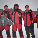
It was quite an adventure: an all-or-nothing mission to map a research station in Antarctica. Like numerous countries around the world, Ecuador’s mapping agency, Instituto Geografico Militar (National Military Geographic Institute of Ecuador or IGM), is a technical institution within the country’s military establishment. The IGM is responsible for developing the national mapping and the geographic […]
An Intro to Internet of Things
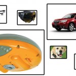
Internet of Things and Internet of Where-Things-Are Your field measurement instrument is connected to the internet as is your data collector; plus your phone and perhaps your watch; your home’s thermostat, security system, and lighting; your television, game consoles, entertainment system; your car, your kids, maybe even your dog’s collar; and soon, too, things like […]
New Markets for Satellite Imagery
In June, the U.S. Department of Commerce, granting a request by DigitalGlobe, gave the company permission to sell its imagery at the best resolutions available from its current constellation. Additionally, six months after its new WorldView-3 satellite is operational, DigitalGlobe will be permitted to sell imagery at a resolution of up to 0.25 meters panchromatic and […]
Imaging Rover on the Canal

A Florida surveying company puts a new technology to the test on an historic canal fronted by 21 subdivisions. Editor’s note: The announcement of the Trimble V10 imaging rover in late 2013 was greeted with a mix of excitement and questions (“what is it?”). With close-range photogrammetry just beginning to reach the toolboxes of surveyors […]