

Esri’s CTO of Digital Twins spent years building the photogrammetry engine underneath ArcGIS Reality before Esri acquired his company outright. A conversation after this year’s User Conference covers what changed when Gaussian splatting arrived, why survey-grade accuracy still matters in an AI-driven capture environment, and what a working geospatial digital twin actually looks like in Zurich.
Reality capture is no longer merely a source of contextual imagery; it is becoming an operational mapping process. Konrad Wenzel’s path to that conclusion — and to becoming Esri’s CTO of Digital Twins — ran through a company he built himself. Wenzel holds a PhD in photogrammetry from the University of Stuttgart and co-founded nFrames in 2013, building software for 3D surface reconstruction from imagery. Esri acquired nFrames in 2020, and the Stuttgart R&D center Wenzel then led became the engineering core of what is now ArcGIS Reality. Capture, he said, has since been democratized by increasingly accessible devices. “Now everyone is enabled,” Wenzel said. “That is really mind blowing.”
From Base Map to Business Process
Wenzel’s central claim is that reality capture has changed status inside the GIS stack. For years, drone and aerial capture served mostly as a contextual layer — a base map, something to look at rather than build on. “I think we have all seen that all of these things become much more core to the business processes,” Wenzel said. “A lot more full survey products.” Paired with AI operating across multiple time periods, he described the shift as a move from one-off mapping projects to a continuous mapping process, where new data arrives constantly and automated tools extract insight from it rather than waiting for a person to review each update. “This is where we think this is actually the new way of mapping,” he said. “A continuous mapping process that we’re actually embarking onto, where every day people contribute new types of data into this, and with the help of AI we can do things like asset monitoring and digital twins with fully automated insights at a much different level than what we have today.”
That shift raises the stakes on the part of the discipline Wenzel trained in before he ever wrote software: knowing exactly how accurate a given dataset actually is. “Ironically, the matters of accuracy and knowing what you’re doing — what type of sensors you use, what accuracy means, this precision — becomes even more important as we work in a multi-temporal, multimodal environment,” he said. Comparing multiple datasets captured over multiple years only works if a lamppost captured twice registers as one lamppost, not two — a problem that only gets harder as more layers, from more sources, get integrated into the same model.
As Accurate as Necessary
Asked directly where survey-grade accuracy fits as reality capture scales up, Wenzel — who trained as a surveyor before he was a photogrammetrist — returned to a principle from his own education. “One of the big teachings was always that the art is to become as accurate as necessary, and that is actually a tricky thing,” he said. “Survey accuracy can also be at these different levels, but I think in recognizing that we have different accuracy levels, we need all of them.” His example was street-level imagery in cities: someone doing a purely visual comparison of current conditions against a prior state can work with an accuracy of a few meters. But as workflows move toward fully automated processes — asset extraction, asset monitoring, automatically relating one data layer to another — the requirement moves toward genuine survey accuracy, on the order of an inch or a few centimeters. “There’s an answer for every sector on that particular question,” Wenzel said, rather than a single accuracy standard reality capture should be held to across the board.
Why Gaussian Splatting, Specifically
Wenzel’s team had already spent years working with the classic representations of reality capture — point clouds, meshes, true orthophotos — including high-resolution capture from ground level and from drones, before Gaussian splatting became a serious option. The earlier attempts to reach a genuinely human-scale, terrestrial level of detail ran into the limits of volumetric mesh representations as they were designed at the time. “We started to invest very early on, even before Gaussian splats were a thing, to investigate different types of technologies,” Wenzel said, pointing to the emergence of neural radiance fields, or NeRFs, as the first real signal that a new class of methods was possible — collapsing optimization steps that had previously been handcrafted into a single learned step. NeRFs themselves, though, were not robust enough for real-world field use, and fell short on performance.
Gaussian splatting itself, as a representation, was not new — the innovation Wenzel’s team seized on was an optimization technique developed by a French research group, using transparency to combine advantages of meshes, point clouds, and volumetric representations in a single format. “If we want to go to the human scale, for people doing indoor data capture and indoor asset extraction and outdoor — bringing the GIS to the ground with these things — we wanted to embark on this,” Wenzel said. Esri productized the technology across the ArcGIS platform almost immediately: ArcGIS can consume Gaussian splats as a fully georeferenced layer, a capability Wenzel said the company built specifically, including the streaming infrastructure needed to use splats in the field rather than only in an office viewer. Esri is also working with the Khronos Group, along with Niantic, Bentley, and others, to shape an open, interoperable format for the technology rather than keeping it proprietary. Esri released Gaussian splat support in November 2025, and Wenzel said adoption spread rapidly across sectors already using ArcGIS Reality products. “Very, very impressive to see for me as well,” he said.
The Shape of a Digital Twin
Wenzel described digital twins less as a single technology than as a maturity process organizations move through as their needs grow. Most start at a descriptive level: bringing together layers of data to produce a static, as-is picture of an environment, with reality mapping supplying the foundation people can actually relate to and extract insight from. From there, organizations tend to move toward real-time-enabled systems, and eventually toward simulation and prediction of future outcomes — each stage building on the last rather than replacing it. “It’s dynamically growing with their needs and their abilities,” Wenzel said. What has changed recently, in his account, is the refresh rate available at the foundation of that process: with capture increasingly done by drones, 360-degree cameras, standard survey equipment, and laser scanners in the hands of non-specialists, some organizations now map active construction sites daily. That frequency lets an organization do more than review current conditions — it lets them build, in Wenzel’s words, a time machine, walking back through prior states of a site inside their own GIS and pulling insight out of the comparison.
Zurich, on the Ground
Asked to ground the discussion in an actual deployment, Wenzel described the city of Zurich’s digital twin program, one of a growing number of citywide and countrywide initiatives running across Europe. The pattern he described recurring across these programs is organizational, not technical: the initiative rarely starts as a spatial-data project. It starts as a digital-infrastructure need, often championed by a mayor’s office or a smart-city initiative, sometimes at the federal ministry level, aimed at building something durable and technology-independent. Reality capture and surveying end up as the practical starting point because they’re accessible to non-specialist stakeholders in a way that, say, a database schema is not.
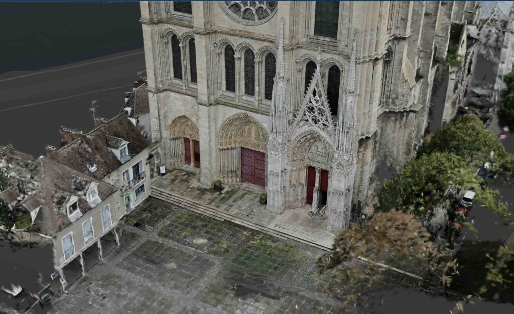
Zurich’s own capture effort had to work around heavy flight restrictions from the city’s proximity to its airport, so the team used large-scale drone capture to build a high-resolution mesh rather than relying on crewed aerial imagery. That mesh became a base layer that was both current and, in Wenzel’s framing, legible — something non-specialists in city government could look at and relate to directly, streamed to any device and overlaid with existing cadastre and administrative data. That legibility is what unlocks the next phase Wenzel described in these programs: once other city departments can see what’s possible, they start asking for their own data to be connected in. In Zurich, that included a project with ETH Zurich to build 3D navigation aimed specifically at accessibility — helping a wheelchair user navigate a space using 3D data — and a separate request from the city’s tram network to overlay their own infrastructure information against the shared base layer. “With seeing what is possible, they step by step get more buy-in from the different types of stakeholders,” Wenzel said, describing a cyclic process he said recurs across most of the digital twin initiatives Esri works on, with reality capture as one key capability alongside BIM data upload, real-time information, and connections to other business systems.
What’s Available Now
Wenzel was direct that reality capture inside ArcGIS is no longer a specialist workflow. “We have made a strong effort to make it simple and available for all types of users where they are,” he said. The tools range from ArcGIS Pro and browser-based workflows to ArcGIS Reality Studio for citywide or countrywide production. The suite also includes Site Scan for cloud-based drone processing and ArcGIS Drone2Map for offline, in-field desktop work.
The next investment Wenzel pointed to is less about new capture hardware than about what happens once capture becomes continuous rather than occasional. ArcGIS is moving, he said, from visualization and annotation toward survey-ready layers that can be updated repeatedly and used to extract further information. “That will be really powerful for digital twins, operating in an enterprise platform like ArcGIS.”