All posts by Ernest Yap
Robot Revolution
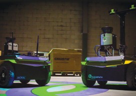
Clearpath Robotics CEO Matt Rendall discusses unmanned systems, land survey, and robotic industry trends. The robot revolution is hitting a big milestone. Robotic use is expanding beyond research activities, aerial applications, and industrial manipulators through a new kind of deployment: the service robot. These robots are autonomous, they’re geospatially aware, and they can manipulate...
Feature: Delivering Intelligence, Not Data
Technology is making geospatial information real-time and relevant. As powerful, easy-to-use applications and up-to-date location data become available, businesses and consumers are significantly increasing their use of geospatial information. Today’s smartphones and mobile tablets easily access online maps, obtain directions to specific addresses, assess traffic patterns en route, and allow users to plan for the...
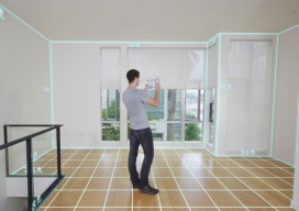
Mobile, Indoor Sensing Devices
Above: 3D sensing mobile devices can create maps of indoor spaces, as demonstrated by this simulated image from Occipital. Credit: Occipital. Mobile 3D sensing devices are big news right now. The announcement of one by Google’s Advanced Technology and Projects (ATAP) group made a stir on social media and the tech blogs back in February...