An award-winning digital twin project is interesting on many levels, and not just because it features one of the world’s most famous landmarks.
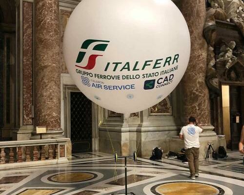
Shown above: The AI-driven camera-based solution Italferr developed to capture the upper dome and galleries. Source: Italferr
Davide Porzio, CDE manager, BIM coordinator, Italferr S.P.A. speaks enthusiastically about building a digital twin for structural monitoring of St. Peter’s Basilica in Vatican City. It is understandable; this cultural icon is an art and architectural marvel. Plus, overcoming the challenges of digitally capturing and analyzing this vast and complex structure is a great source of pride for Porzio and his colleagues at Italferr.
The Bascilica
The present-day Basilica Papale di San Pietro in Vaticano, or more simply St. Peter’s Basilica, was completed in 1626 to replace the aging fourth century structure built during the reign of Roman emperor Constantine the Great. Dominating the skyline of Rome, the dome rises 136.5 meters (447.8 feet), making it the tallest dome of its kind in the world. Its internal diameter is 41.5 meters (136.1 feet), and together with the nave, facade, additional towers and encompassing structures, the total area is 21,095 square meters (227,070 square feet)— more than five acres. Michelangelo, once involved in the design and construction already under way, incorporated the designs of the initial architects into the grand vision that emerged. Together with the companion St. Peters Square (capacity 300,000) this is one of the most recognizable and visited sites in the micro-state of Vatican City. As many as five million people visit the Vatican annually.

Basilica Papale di San Pietro in Vaticano. Source: Wiki Commons
“We began, of course, with data acquisition and creation of a 3D reality mesh,” said Porzio. “However, this was only the first step in seeking a progressively deeper understanding of many aspects of the building with the goal of comprehensively monitoring the entire structure.”
Over the past two decades, we’ve gotten used to seeing many examples of historic structures scanned, often for preservation uses, but this project stands out with it’s depth of digital twinning to accommodate multi-faceted monitoring, planning, and operations. This was also the view of the jury for the surveying and monitoring category of the Year-in-Infrastructure Going Digital Awards 2023 (YII 2023), an annual international event hosted by Bentley Systems, held this past fall in Singapore. The award went to the Italferr team for this project.

The Italferr team accepting the award for Surveying and Monitoring at the Year-in-Infrastructure Going Digital Awards, held in Singapore in October of 2023. Letizia Attili and Davide Porzio (center). Source: Bentley Systems
This was not Italferr’s first walk on the YII awards stage. In 2019, they won the Railways and Transportation category for innovation in the design of the HS/CA Napoli-Bari Line. The core focus of the company has been rail and transportation, forming in 1984 as a consulting engineering and project management arm of the Italian state railway company. Italferr oversees, for instance, the construction of Italy’s high-speed rail, and they consult for other countries in Europe. An innovator in the digitization of design, construction, and operations, Italferr has grown a deep bench of expertise and technological capacity for many related fields, such as 3D reality capture and BIM. When the opportunity to take on the digital twinning of St. Peters came about, Italferr easily demonstrated their ability to rise to the task.
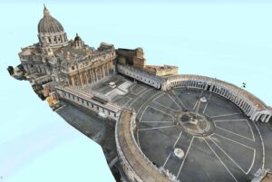
3D model of Saint Peter’s Basilica and Piazza. Source: Italferr
Sensing and Sensitivities
The cultural, religious and historical sensitivities surrounding this structure were not lost on Italferr. Complex scheduling and precautions were applied throughout the project. “For this kind of survey, we used a lot of different technologies for the external elements, such as drones and terrestrial laser scanners,” said Porzio. “But for the internal part, we balance technical requirements with the spiritual side of this iconic building. We also worked at night as there are many people in the building during the day.”
One example of the team’s resourcefulness was their solution for capturing features in the upper dome and galleries. The use of a drone would have been impractical considering telecommunications issues, and a hazard If it strayed off course it could damage invaluable structures and art. Their answer was a balloon, carrying an AI-driven camera-based capture solution. There are several technical advantages to this gentle approach, namely in resolution and precision.
Key to creating a uniform model from the multiple sources was Italferr’s use of Bentley Systems iTwin Platform and iTwin Capture. Italferr has long been engaged in the Bentely Systems software environment, as many large transportation and infrastructure concerns are, having using MicroStation, OpenBuildings and other software for engineering design and ProjectWise for management and delivery of digital design data. For the Basilica modeling the team also leveraged LumenRT for visualizations and simulations (e.g., realistic lighting conditions) and OpenCities to manage the entire site as a digital twin.
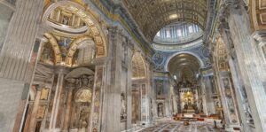
The full color, high-precision 3D model of the basilica interior. Source: Italferr
Millimeters for Multi-use
Using a combination of terrestrial scanning, conventional surveying, and photogrammetry, Italferr captured in full color and very high resolution. This was not a project that could be accomplished by simply walking though the building with a backpack or hand-held SLAM scanner; those could not meet the sub-centimeter requirements, nor for some features where just a few millimeters resolution is desired. In particular, such high precision is requisite for the structural monitoring program that Italferr was developing for the client. “By combining scanning and imaging, we are able to achieve precisions in millimeters for key features,” said Porzio.
The Baseline
This enhanced BIM model will serve as a baseline for analysis, monitoring, and condition measurements over time, This is where an initial high precision, detailed model was essential.
“We are able to form a better understanding of conditions, for instance in evaluating crack patterns in the structure,” said Porzio.
“For this reason, just scanning and imaging is not enough,” said Porzio. “We perform also examine the state of materials that may be exhibiting poor characteristics and conditions in the old part of the Basilica. We have to understand the mass, the materials inside the wall, the roof, and so on. And for these starting from these responses, the asset’s material characterization, we also produce a BIM model with a lot of information for monitoring and maintenance purposes.”
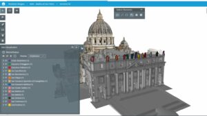
The BIM model, identifying exterior sculptures. Source: Italferr
We plan to use the reality mashup for comprehensive monitoring, reducing downtime and avoiding disruption and potential damage,” said Porzio. “For instance, where boreholes would have traditionally been used, we can use non-destructive radars. So important as to not damage valuable artistic features.” A key goal for the model is to plan a monitoring system, with IoT sensors and subsequent capture, while increasing efficiency of inspections through pre-planning.
It will be wonderful to check back and see how the utility of this high-precision and data rich digital twin improves monitoring and management of this iconic building.