All posts by Marc Delgado, PhD

Virtual Cities Are Rising
Cutting-edge 3D city models lead the way to better urban planning via digital simulation Take a peek at Helsinki’s virtual 3D city model and what might at first seem to be just rows of solid objects soon reveal themselves as handsome blocks of buildings that line gridiron streets. This is the digital doppelganger of Finland’s...

Every Drop Counts
With help from GIS, these five megacities are future-proofing their water infrastructures so that sufficient water supply will no longer be a pipe dream. Megacities are a thirsty lot. These large and overpopulated metropolises have greater than 10 million inhabitants who consume more water than what their reservoirs can supply. Water shortages are commonplace, and...

That Scan-Do Spirit
Preserving heritage sites and objects is a race against time and elements. But thanks to scanning technologies, experts are now more confident humanity’s cultural legacy can be saved. One of the most iconic and visited landmarks in the world is the Notre-Dame Cathedral in Paris. So, it came as a shock on the evening of...

A BIM of Hope for the Environment
This innovative building information modeling tool aims to reduce the construction sector’s carbon footprint. But unlike other practices, it begins at the design phase. The construction sector is in a conundrum. Decades of non-stop sawing and hammering have been wonderful for the world’s economy yet dismal for the environment. In the latest figures from the...
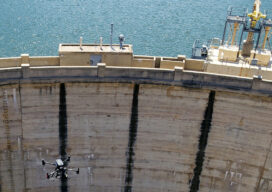
Thinking Ahead
From mapping catchments to inspecting dams, there’s a solid future for UAS technology at public utility companies like the Salt River Project in Arizona
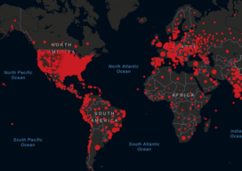
When Mapping Goes Viral
Digital mapping has boomed during the COVID-19 pandemic. From tracking cases to allocating vaccines, GIS technology is at the frontline of the war to beat the virus.