All posts by Marc Delgado, PhD

Galapagos in 360 Degrees
“Like cinders… infernal… leafless…” Charles Darwin wrote those words in his diary on September 16, 1835, after setting foot for the first time on the Galapagos. Darwin, whose scientific work in the far-flung archipelago considerably changed our understanding of how life on Earth evolves, was a keen observer of nature. And on that day, while...

BIM It Up and Fly Them In, Mactan-Cebu Airport!
Designed using building information modeling, Mactan-Cebu International Airport is a tribute not only to technology but also team collaboration and creativity. Featured image: Photomontage (by Marcel Lam) shows the BIM model combined with an actual photo of the Mactan-Cebu International Airport’s roof. Everything about the design of the newly built Terminal 2 at the Mactan-Cebu...

Teaching Roots and Research at the University of the Philippines
One of Southeast Asia’s oldest surveying schools is promoting the use of geospatial technologies and thriving in the digital age. When Louie Balicanta walks inside the high-ceilinged corridors of Malcolm Hall on his way to teach land surveying, he knows how much responsibility rests on his shoulders. Not only is he an assistant professor at...
Technology to Buy Into: Riding High on AI
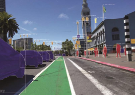
Artificial intelligence is making huge waves in the geospatial industry, changing how location information and BIMs are created from big data. Meet three startups at the forefront. (Image above: By applying computer vision to street imagery, Mapillary detects map data at scale.) Startups in the AEC realm have skyrocketed over the last decade. The availability...

A Dam Good Mix
Above: A view of the Brighton Dam in Brookeville, Maryland, from one of the project’s UAVs. Combining UAVs and 3D computer vision can make infrastructure inspections cost-effective. More than 70% of the 90,000 dams scattered across the U.S. are, according to the American Society of Civil Engineers (ASCE), half a century old. The age of dams,...
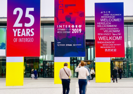
Outstanding Geospatial Trends at INTERGEO 2019
INTERGEO, the world’s largest summit in positioning and geospatial tech, wrapped up last week in Stuttgart, Germany, proving that even after 25 years it still can be a great show. It’s the biggest geospatial event of the year where companies around the world showcase their current innovations for the industry, and the xyHt team was...