All posts by xyHt

Weekly xyHt News Links: 03/22/2019
Airbus launches OneAtlas service for GIS imagery, data Hexagon acquires Thermopylae for 5D visualization Microdrones Will Host a New Wednesday Webinar April 3rd, 2019 SlantRange releases new products Laser scanning professionals can now convert point clouds into interactive, fully immersive 3D buildings online FARO® Releases FARO ZONE 3D 2019 for Public Safety
Weekly xyHt News Links: 03/15/2019
Golden Software Releases Grapher 14 with Enhanced Plotting Functions Introducing the senseFly eBee X with MicaSense RedEdge-MX, a seamless dual solution for accurate and efficient crop analysis PIX4D announces first user conference in Denver, Colorada SimActive Releases Version 8.1 with Advanced Editing Tools
Weekly xyHt News Links: 03/8/2019
Microdrones and ESP Associates showcase mdLiDAR3000 workflow in 3 new videos Geo Data Explorer App – Professional GIS data visualization and analysis app. 5 Ways the World Depends on Geomatics Bentley Systems Introduces Mixed Reality App for Infrastructure Construction Projects Using Microsoft HoloLens 2 at Mobile World Congress Event Trimble Announces Next Generation Mixed-Reality Device...
Weekly xyHt News Links: 03/1/2019
Esri Acquires indoo.rs and Announces ArcGIS Indoors Release Bentley Systems Introduces Mixed Reality App for Infrastructure Construction Projects Using Microsoft HoloLens 2 at Mobile World Congress Event Trimble Announces Next Generation Mixed-Reality Device with Microsoft HoloLens 2 Technology for Front-Line Workers in Construction, Oil and Gas, Manufacturing and Mining Hexagon Advances its 5D Visualisation Portfolio...
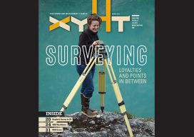
xyHt Magazine March 2019 Issue
Click on the cover below to view the March 2019 issue of xyHt magazine. Articles in the issue include (links will turn live throughout March): GPS Week Rollover – Don’t Panic (Update) – This article explains what the GPS Week rollover is and why it is of interest or concern to GPS users. Surveyors: Loyalties and...
Weekly xyHt News Links: 02/22/2019
New Lightweight, Rugged Trimble T7 Tablet Elevates Productivity on the Construction Site Ordnance survey’s DRONE mapping project: Pilotless planes that fly at 67,000 feet, run on solar power and stay aloft for months at a time will observe anywhere in the world in a single flight FARO® Introduces FARO RevEng™ for Design Professionals Topcon’s MAGNET...