
Blog
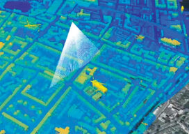
Protecting Urban History
Maximizing the data collected from airborne lidar helps protect historic structures in older cities In Part I last month, we outlined the research performed in Dublin, Ireland, and Brooklyn, N.Y., using hyperspectral scanning to help old cities protect historically significant buildings during new construction projects. In Part II, NYU professor, Dr. Debra Laefer, explains how...

It’s All About the Journey
I was recently looking at the archive of past Field Notes and was amazed how far back I had to go to get to my first one – March 2016. What began as a lone article submission on subsidence in California has resulted in a five-plus-year journey of writing this monthly piece— a journey I...

A BIM of Hope for the Environment
This innovative building information modeling tool aims to reduce the construction sector’s carbon footprint. But unlike other practices, it begins at the design phase. The construction sector is in a conundrum. Decades of non-stop sawing and hammering have been wonderful for the world’s economy yet dismal for the environment. In the latest figures from the...

xyHt Weekly News Recap: 11/12/2021
Fugro Launches New Generation of Uncrewed Surface Vessels Teledyne Geospatial to Showcase Hardware and Software Solutions at Geo Business 2021 Trimble Establishes Dr. Gladys West Scholarship Program Woolpert Selected to Collect Aerial Lidar Data for Ohio 3DEP Women in Technology Nominations Due by Dec. 31 Bill Introduced to Reform National Flood Insurance Program First American...
xyHt Weekly News Recap: 11/05/2021
Geo Week Keynote Speakers Announced NV5 Geospatial Extends Leadership in Canadian Hydrospatial Market Fighting Fires with Satellite Communications and Infrared Mapping Bell, Esri Deliver Integrated Smart City Ecosystem to Empower Canadian Communities MARACOOS, MARCO to Expand Ocean Mapping and Research Partnership Pix4D Launches the viDoc RTK in USA and Canada Geo Week Nominations for Excellence...
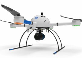
Autonomy Comes to UAVs
Trending tech has UAV software looking futuristic To a certain degree, autonomous operations are already baked into the current state of data collection (aka reality capture) software for UAVs. Pre-mission planning consists of using a map-based interface to highlight the area that needs to be mapped or inspected, the appropriate flight pattern and height (AGL)...
Advertisement