
Los Angeles uses GIS technologies to help residents find respite during heat waves
In late August 2022, a vicious heat dome sat over Los Angeles just when summer would typically fade into fall. For a week, temperatures climbed as high as 115 degrees in parts of Southern California—and didn’t cool off much at night. The extreme heat led to an increase in wildfire risk, power outages, and harm to human health and ecosystems.
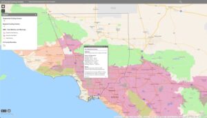
While climate change affects everyone, there are disproportionate negative impacts on communities of color, older adults, young children, and outdoor workers. In LA, in predominantly Black and Latino lower-income neighborhoods, there is less climate-adapted infrastructure than in wealthier communities. Having few trees, and many buildings and roads creates an urban heat island effect. Concrete and asphalt store heat—warming the days and nights, leading to higher incidence of hospitalizations and premature deaths.

An app directs Los Angeles residents to places like public pools and shaded areas where they can cool off.
Extreme heat waves in California are lasting longer and are the deadliest climate threat residents face. There are efforts in low-income neighborhoods to add recreation center options and to plant trees to provide shade equity, but some of those projects, including the redesign of the LA River greenway, will take time to bring benefits.
In June 2022, Los Angeles promoted Marta Segura to become the city’s first chief heat officer. Applying geographic information system (GIS) technology to map the city’s areas most affected by heat and social vulnerability—a climate justice framework—helped Segura expand the city’s services and deploy resources during extreme-heat events.
“LA now has six times the number of heatwaves we once did, with more exposure from heat-stagnated air pollution and less time for our bodies to recover,” Segura said. “Some neighborhoods without trees, shade, and open space suffer four times the number of hospitalizations and premature deaths than areas with a greener, more climate-adapted infrastructure.”
Where Residents Can Take Respite from Extreme Heat
During the heat dome event, local emergency departments saw an additional 1,500 patients per day. According to the Center for Public Health and Disasters at the University of California, Los Angeles, 40 heat-related deaths were occurring daily by the fifth day of the heat wave.
Visitors to the Cool Spots LA App can see the cooling centers across the region.
“As the city’s chief heat officer, I knew we had to act quickly to convey information about the city resources that could be a refuge from the heat to our communities,” Segura said. With Segura’s vision and support, the city launched Cool Spots LA, a web application showing residents where they can cool off during heat events. This is the first of many resources Segura is mandated to create as she develops the city’s Heat Action Plan and Climate Vulnerability Assessment, which will prioritize extreme-heat response.
The app uses GIS technology in a single interactive directory to display more than 200 cooling centers. In the app, residents can input an address, cross streets, or a landmark, or enable the app to use their current location to begin their search. In addition, the app includes a map with colorful icons to indicate specific types of cool spots, such as hydration stations, recreation centers, public pools, and libraries.
To populate the map, Segura gathered data from the city’s departments of emergency management, public works, water and power, and recreation and parks, as well as public libraries. Segura, in addition to being chief heat officer, leads the Climate Emergency Mobilization Office. She coordinated support from Eva Pereira, the city’s chief data officer on the mayor’s data team, who leveraged GIS to design and build the web app.
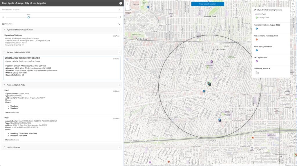
Zooming into the neighborhood level reveals a more detailed view to see centers by facility type.
“This is how constituents expect city leaders to lead. We must co-create and co-design services and projects seamlessly,” Segura said.
To promote a variety of locations and advance equity, the team gathered data on augmented cooling centers—found within 73 libraries, select recreation centers, and senior centers—and cooling spots such as shade structures, bus shelters, and hydration stations throughout Los Angeles to put in the Cooling Spots map.
Visibility of Cooling Centers Results in Record Relief
Seeing all the options on a map guided decision making on where more were needed. The city added 16 augmented cooling centers in underserved areas from a previous count of six.
“We had the highest cooling center attendance we have ever had, in part because of our app,” Segura said. Calls to 311 and a social media campaign, #heatrelief4LA, promoted the app.
The Cool Spots map will continue to grow and change over time as investments in green infrastructure expand. Earlier this year, California Gov. Gavin Newsom announced a historic $800 million heat action plan. The plan details a strategic approach to adapt and strengthen community resilience to heat threats.
In September 2022, Los Angeles mayor Eric Garcetti announced an initiative to offer rebates for energy-efficient air conditioners—which is being informed by the Cool Spots LA app and the city’s heat risk map. “The impacts of the climate emergency are on our doorstep, and as we continue our work to make Los Angeles a carbon-neutral city, we can’t wait to bring solutions to people on the front lines of this crisis today,” Garcetti said in a statement.
Los Angeles isn’t the only city that has added an extreme heat officer. The Adrienne Arsht-Rockefeller Foundation Resilience Center’s (Arsht-Rock) Extreme Heat Resilience Alliance catalyzed support for the concept and, worldwide, there are currently seven chief heat officers. In the United States, Miami and Phoenix made this commitment to combat climate change. Also recently, the Biden administration launched a climate change portal that addresses extreme heat, providing a live dashboard to view real-time extreme weather patterns. The portal also provides data about vulnerable people, so governments can assess and assist communities to make equitable adaptations and responses.

Author: Patricia Cummens
Patricia Cummens is the Director of Government Strategy and Policy Solutions at Esri. Her skills bridge the gap between policy and technology, helping governments understand the value of geospatial data and GIS technology for efficient, smart government. In 2018, she was named a Top Woman in Tech, by StateScoop. She serves on the National Geospatial Advisory Committee and the National Governors’ Association Smart States Advisory Board.