
Blog

Lidar and The Lost City of the Monkey God
The timing was uncanny; I had just finished Douglas Preston’s The Lost City of the Monkey God when news of another major, new, lidar-enabled archeological find in Central America broke—at the same time I was attending the International Lidar Mapping Forum (ILMF) in Denver, Colorado. Then, while I was attending Teledyne Optech’s product presentation at...

Weekly xyHt News Links: 02/23/2018
Topcon Acquires ClearedGE3D, a Technology Leader in 3D Modeling and Construction Verification Software GeoSLAM to Demo Time & Cost Saving 3D Mobile Laser Scanners for Construction Applications at 2018 AGC Convention
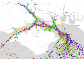
AIS: Using Shipping Data in GIS
We’ve all been dazzled by those awesome maps that animate ships or aircraft using AIS, as they move in near real time, but how do they work? What magic sits beneath the hood? As luck would have it, whilst working with the offshore wind farm industry I had to do a lot of vessel analysis,...
Weekly xyHt News Links: 2/16/2018
NSPS COMMENDS CONGRESSIONAL INTRODUCTION OF THE IMAGES ACT, H.R. 4905
What I Saw at ILMF 2018
ILMF is an outstanding conference for all things lidar, including airborne, terrestrial, and underwater, as well as new remote-sensing and data-collection tools and technologies. I try to attend every year because it never gets old; there are plenty of new and exciting technologies, both on the exhibit floor and in the many workshops and presentations....
Weekly xyHt News Links: 2/9/2018
Trimble Acquires e-Builder to Expand its Construction Management Solutions Orbit GT releases major update of 3D Mapping Cloud Teledyne Optech announces the new ALTM™ Galaxy PRIME: Higher point density increased range performance and superior cost reduction! Korea will launch its own satellite positioning system Trimble Introduces Next Generation GNSS Reference Receiver Delair offers advanced UAV for...
Advertisement