
Blog

Weekly xyHt News Links: 04/13/2018
Trimble Launches Marine Positioning GNSS Receiver Sky Power and 3W-International are Introducing Engine Construction Kits for the First Time at Xponential 2018 Latest YellowScan Lidar System Designed for UAV Surveys Trimble’s Forensics Solution Enables Efficient Data Collection for Crash and Crime Scene Investigators Topcon Announces New Features Added to Web-based Service for Mass Data Processing...

Registration Open – Young Surveyors Network – Joint Meeting 2018
Plotting a Course for the Future Registration is now open for the Joint Meeting of the FIG and NSPS Young Surveyors Networks October 17-18, 2018 – Hyattsville Maryland, USA The meeting will be at the College Park Marriott hotel and conference center in East Hyattsville, MD, near the University of Maryland‘s campus, and is being held...
BigSUR
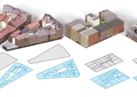
A software team creates a large-scale, structured, urban reconstruction system that handles multiple data sources with deep learning. Today, big data is ubiquitous: we have more information than ever, but combining and understanding all this data has become the challenge. This is particularly true for 3D cartography as we view our continually changing world with...

Rocket Billionaires
Here’s a great example of serendipity. Not so long ago I took a break from my daily routine and flipped on the TV. The set was tuned to the science channel, and just as the screen flickered to life I beheld the sight of the first launch of SpaceX’s Falcon Heavy as it lifted off....

Aerial Imagery to the Rescue
Events in 2017 demonstrated without any doubts or reservations how vitally important georeferenced aerial imagery is in assessing damage and supporting relief efforts following a natural calamity. Last September, an impromptu consortium of companies in North America mobilized their forces and collected and analyzed mountains of data at near cost to help out in what...
Weekly xyHt News Links: 4/6/2018
Ouster Launches Two New LIDAR Sensors, Adopts NVIDIA DRIVE™ AI Platform Topcon introduces new laser series designed for distance and accuracy in construction projects What Drone Operators Need to Know About the Expansion of LAANC East View Geospatial Launches On-Demand Milspec Geospatial Data Topcon and Bentley to hold collaborative Constructioneering Academy in Brisbane senseFly and...
Advertisement