Keeping tabs on assets with wireless monitors is not just for those dirty, dangerous or distant jobs
By Simon Brightwell
Wireless remote condition monitoring is playing an ever-greater role across the geospatial sector. The capabilities of this family of technologies are being recognized in more and more applications and they provide surveyors and other geospatial professionals with complementary and alternative ways of gathering high-value data on the attributes and behavior of assets.
Because remote monitoring enables users to get the information they need without actually being on site, the technology has grown around applications summarized by the three Ds: dirty, dangerous, or distant. Classic applications therefore include railroads, tunnels, slopes, and mines — but the game is changing and a number of factors are leading to growing adoption in other applications.
These include buildings, bridges, monuments, and other structures. It is likely that around 100,000 wireless sensors are in use around the world today, feeding information to stakeholders on structural or ground movement, environmental parameters, such as temperature or groundwater pore pressure, and engineering parameters, such as stress and load.
Built on 20 years of development and improvement, the technology is well-established; capabilities and limitations are widely understood and statutory approvals are in place. In terms of geospatial applications, a combination of MEMS and laser-based sensor nodes can measure rotational movement, settlement, heave, and tunnel convergence. Specialist applications, such as railroad track studies can measure changes in cant, twist, and slew.
The technology is effectively part of the industrial Internet of Things (IoT) and has benefitted from progress in cellular communications, battery performance, and microprocessor efficiency. A typical wireless remote condition monitoring system comprises three main elements: sensor nodes, a wireless communications platform, and a user portal.
Sensor nodes measure a range of parameters, the most widely used being high-precision tilt sensors, which measure rotation about the horizontal axis. Other widely-used sensors are crack/displacement gauges, optical displacement sensors, and a family of vibrating wire-based devices including piezometers, strain gauges, load and pressure cells, as well as in-place inclinometers, temperature, and moisture sensors.
The wireless communication platform (WCP) transmits information from the sensors to a monitoring hub before collating and transferring data to the Internet or directly to a client’s private network. The first choice for flexibility and network intelligence is usually a 2.4 GHz mesh platform, such as Senceive’s FlatMesh, in which nodes ‘talk’ to their neighbors, relaying data in a series of hops to the outside world. Where deployment is needed over greater distance (kilometres) a lower frequency LoraWAN radio platform, such as GeoWAN™, which operates at a frequency of 900 MHz, can be used. While the lower frequency reduces the scope for automation and intelligent solutions, it does result in longer range and enables transmission through obstructions such as buildings.
A user portal enables stakeholders to view and interact with the monitoring output. Most remote monitoring setups offer a bespoke viewing tool and also offer delivery of data in formats compatible with industry standard management software, such as Leica GeoMoS Trimble 4D Control, Topcon Delta Watch, Mission OS, Geoscope, Eagle.io, GeoCloud, Calyx OMS, and many more.
Varying degrees of remote interaction are possible. Senceive FlatMesh™ users can change configuration settings such as sampling frequency and check the health of their system (battery level, connection strength…) without site visits. This can represent a significant safety and cost benefit where site access is constrained.
Like so many other technical innovations in recent years, the growth of remote monitoring is, in part, built around the principle of making it easy to use. A system can be installed by a technician with only basic experience and be operational within an hour. Instruments and gateways are usually pre-configured before deployment and can be “seen” remotely as soon as they are fixed to whatever they are monitoring.
Limitations
As capable as the technology is, there are limitations. While it is often described as maintenance-free, an occasional site visit is sometimes needed to clean solar panels and check the gateway, for example. Power supply is a consideration. While sensor nodes are powered by long-life batteries that require replacement only after 10 to 15 years, the comms gateway requires external supply. Usually, a solar panel is all that is required, but this can be problematic for sites deep underground or at northern latitudes with reduced daylight hours. Most setups rely on transmitting data via the cellular network, so are reliant on a reasonably strong and consistent signal. Installation is relatively simple, but it can still go wrong, for example using inappropriate adhesive to fix nodes or bad installation can lead to bad data. Access to a reliable off-site support team to avoid and address such issues is essential.
As with any monitoring approach, there is a need to properly define significant behavior in the data in order to set reporting thresholds. This usually requires a period of weeks or months to build a baseline dataset.
Remote Monitoring In Use
A growing number of instrumentation providers are operating in North America. Potential users can choose a source kit from a distributor and install it themselves, or engage a company specializing in instrumentation and monitoring solutions.
One of the largest and longest established of those companies is GEO-Instruments, which has been pioneering this technology across the civil engineering sector for 18 years.
“The development of wireless sensor technology in the growing I&M field has been a game changer,” says GEO-Instruments director of business development Kenny Campbell. “It provides low cost, simple monitoring solutions. It is especially useful for large, complex projects where access is challenging and cable lengths extreme.”
Pre-construction
Remote monitoring tools provide an alternative methodology to “conventional survey” approaches in many infrastructure, mining, and construction-related applications. Geospatial and geotechnical experts at GEO-Instruments often use the technology in new-build projects, for example, in monitoring the consolidation of ground prior to construction.
The GEO team has been kept particularly busy by the rapid growth in large e-commerce fulfillment centers. These need extensive areas of flat, stable ground to be prepared and considerable sums are invested in ground improvements, which often include heaping additional soil onto the site to compact the underlying ground. To optimize the process in terms of budget and duration (often exceeding six months), and to verify its effectiveness, there is a need to monitor consolidation over time. This typically requires reliable measurement of pore-water pressure, settlement, and surcharge height.
Traditional monitoring involves instrument technicians and survey crews walking the site, which is labor-intensive and inefficient. Each crew reports separately, so measurements must be integrated. Pressure on budget means there is a temptation to minimize measurement frequency — and therefore compromise the dataset.
Automated remote monitoring removes these constraints, reduces costs, and potentially leads to an accelerated construction program. The automated approach varies between sites, but it often uses optical displacement sensors (a type of laser extensometer) to measure changes in surcharge height. It also uses integrator nodes that can enable third-party instruments to “talk” to the wireless network and the outside world. A common example in this application is the use of vibrating wire piezometers to measure pore-water pressure.
This ability to monitor gradual settlement without leaving the office has many applications — not least in road and rail earthworks, mine tailings dams, and flood defense levees.
During Construction
Optical displacement sensors installed in locations that would be hard to access for manual survey on bridge piers during upgrade work operate as a laser extensometer measuring relative movement between bridge piers during the strengthening works.
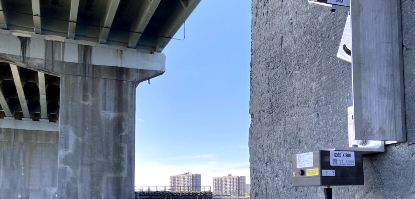
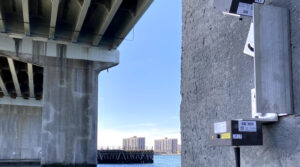
Another common requirement is to monitor the effects of ongoing construction activity on existing infrastructure. A case in point is New York’s Cross Bay Bridge from Brooklyn to Rockaway Beach, where scheduled upgrades for the six-lane bridge include replacement of fender systems and improvement of scour protection.
In order to meet the requirement for the bridge to remain open during the work, GEO-Instruments was charged with monitoring the piers for movement during construction. A fully automated monitoring solution was deployed. This utilized Senceive’s optical displacement sensors to measure movement of the structure — specifically to monitor rotation of the piers and changes in the distance between them, both perpendicular and
at an angle of 45 degrees. The remote, wireless nature of these sensors made installation quick and easy.
Costa Blanca Tunnels
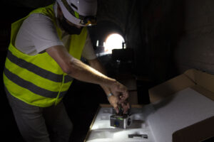
Installing remote monitoring sensors in the Costa Blanca tunnels.
Construction and upgrade of tunnels is a complex task; engineers need a constant flow of information on the behavior of the tunnel, the ground, and the buildings, and structures that may be in place above. The recent upgrade to three Spanish tunnels, as part of the strategic Mediterranean Corridor project, provides a good example of how remote monitoring can help to reduce uncertainty and manage risk.
Wireless sensors arrive on-site pre-configured and are live as soon as they are fixed to a structure.
The monitoring solution had to be quick to install, tough enough to work with piling rigs just a few feet away from the sensors, and precise enough to provide reliable information 24/7. The solution comprised three types of wireless sensor, all connected via a GeoWAN™ long-range wireless communications platform.
Wireless tilt meters mounted on horizontal beams were fixed to the tunnel walls to detect settlement. Optical displacement sensors were fixed in triangular arrays at the tunnel haunches and crown to measure convergence, and borehole extensometers were used to monitor ground movement above the tunnels.
Conclusion
All three project examples demonstrate the common thread that wireless remote monitoring is attractive at sites that are tricky to access, where fixed cables and wires would be problematic, and where a quick, efficient set-up process is needed. It is worth noting that the first two examples also combined “conventional” surveys using automated total stations with remote monitoring methods.
Technology has a tendency to get smaller, faster, and cheaper and there is every indication that wireless remote condition monitoring will be no exception — meaning those 100,000 sensors in use now will soon be joined by another 100,000.