Category Archives: Cartography

Virtualization: the Greatest Tool You Don’t (Currently) Use
This post is dedicated to a good friend, Chris Johnson, who, when we worked together a few years back, introduced me to this cool new word: VIRTUALIZATION. You see, Chris is an IT guru (see: enterprise systems architect)—a friend that every GIS guru should have so that you’ve got someone to pick up the pieces...

The Problem with GIS and Augmented, Virtual, and Mixed Reality
Over the last few years, altered realities technology has exploded, and now, with the introduction of Apple’s ARKit and Android’s ARCore, AR, MR, and VR are well within the reach of the non-developer. I can confirm this as I’ve created a few AR apps and MR apps myself over the last few months, with no experience...
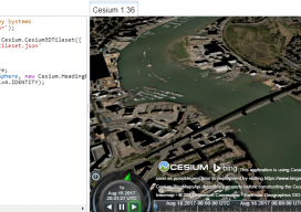
Add 3D Tiles to Cesium 1.36 to Make 3D Virtual Scenes
As blogs come, this has to be (for me) one of the longest. You see, I’ve been playing with Cesiumjs since its beginning and following the exciting beginnings of the “3D Tile” for the last 3 years. I’ve waited patiently, waiting for the moment I could share with the world how fantastic this new technology...

Night in the Afternoon: A US Solar Eclipse
What you need to know about the 2017 solar eclipse The upcoming solar eclipse will leave a 70-mile-wide trail of darkness across the United States on August 21, 2017 (see the map of the eclipse path on pages 44-45). This will be a once-in-a-lifetime event for many people. While another total solar eclipse will make...
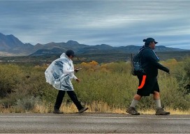
Mapping the 1874 Yavapai-Apache Exodus Trail
Modern hikers map the Exodus Trail of the Yavapai-Apache Nation with GPS. By Everett Phillips, Philipp Hummel, PLS, and Bryan Frazier; introduction by Judie Piner In 1875, both the Yavapai and the Apache people were removed from their Rio Verde reservation in Arizona and force-marched by U.S. soldiers in terrible conditions, nearly 200 miles, to...

Smart Cartography
Six examples of how old-fashioned navigation aids have been transformed into today’s smart maps Berlin, Germany 25, April 2017 | The 65th Cartography Conference run by the German Society for Cartography (DGfK) in 2017 is dedicated to smart cartography. At INTERGEO 2017, the community is showcasing its credentials as an innovative scientific discipline that excels...