Mapping the entire U.S. seafloor is an epic task. The country’s new national hydrographer says it can be achieved by coordinating efforts and using the latest technology.
“We know more about Mars than we do about our own oceans,” says Capt. Rick Brennan, chief of the Hydrographic Surveys Division at the Office of Coast Survey, a line office connected to the National Oceanic and Atmospheric Administration (NOAA). “I would like that old adage to be a thing of the past.”
Brennan’s observation is not just spot-on, but also a timely reminder of our need to shore up the information that we have about our planet’s biggest body of water. A century after the first deep-ocean bathymetric data was collected by the British in the 1870s, only a measly 20 percent of the world’s ocean floor has been plotted. Compare that area with our celestial neighbors and it becomes evident that so much of the surface underneath our oceans remains unmapped. NASA completed a detailed map of the Moon’s entire topography last year. And way back in 2014 the USGS, the country’s geological survey agency, had already drawn the surface map of Mars.
For the U.S., mapping the extent of the two big ocean bodies that border it will not only help protect the resources that the seas provide, but will improve its management. According to NOAA estimates, the marine economy contributes a great sum to the country’s coffers, totaling to about $373 billion in annual gross domestic product. It also provides 2.3 million jobs.
Seafloor mapping must be done within the country’s Exclusive Economic Zone (EEZ), the area in the ocean to which the U.S. has sovereign rights. It is one of the largest EZZs in the world, next only to France. Its inner boundary starts at the offshore edge of each state’s coastal waters and its outer boundary is measured from the low water tidal baseline out to 200 nautical miles. This zone covers over 3.4 million square nautical miles of ocean, an area larger than all 50 states combined.
“We have more submerged U.S. territory than we have dry territory,” says Brennan. At this enormous scale, it may not be surprising to know that only a portion of that EZZ has been mapped. The potential benefits of collecting bathymetric data can be as wide as the ocean itself, and Brennan believes that it is vitally important to map the seafloor.
“Novel pharmaceuticals are being created after finding new plants and animals in these unmapped regions. We are uncovering vast areas of critical minerals necessary to power the future’s renewable energy. We are discovering wildly productive ecosystems that need to be protected in order to preserve fish stocks,” he says. “All of these are critical to our nation, but all require a map to successfully assess and manage them.”
Not Just a Drop in the Ocean
Brennan, who has a master’s degree in ocean mapping from University of New Hampshire, has been working as a NOAA Corps Officer for almost three decades.
“My 27 years at NOAA have all been centered around nautical charting and hydrography. I have served more than 10 of those years at sea aboard NOAA ships with one small boat command and two ship commands – all conducting hydrographic surveys from Alaska to the Caribbean.”
The bathymetric data that Brennan’s office acquires is primarily used to support marine transportation in the form of electronic navigational charts. “Mariners rely on modern, timely, and accurate charts to move in and out of port safely,” he says. “Today’s ships are frequently operating with a foot or less of free space under their keel, so the data must be very accurate.”
Yet measuring the depth of the world’s seabed is important not only for navigation. It also serves the needs of other sectors such as fisheries, energy and telecommunications. Monitoring environmental change in order to protect populations from geo-hazards such as floods and tsunamis also requires bathymetric information.
“While our primary consumer is the mariner, we are working to make the bathymetry available to a much broader array of scientists,” says Brennan. “We have demand for our bathymetry from habitat assessment and conservation scientists, hydrodynamic modelers, as well as coastal zone managers,” he says. “Our intent is to make our data easily available and consumable for these various uses.”
With his long professional experience in ocean mapping, Brennan knows exactly the figures to drive his point of the necessity to map the seafloor.
“Currently only about 41 percent of the U.S. EEZ is mapped. And by identifying a mapped area as one depth measurement per 100-by-100 meter grid cell, the minimum standard used to begin to define the problem, that leaves us with 1.99 million square nautical miles of seafloor unmapped,” he says. “This is a huge area.”
Clearly, much work needs to be done in order to complete the country’s seafloor map. Last year, the U.S. government released an ambitious plan to do just that, outlining its activities in the National Ocean Mapping, Exploration and Characterization Strategy (NOMEC), and opening it up for public discussion in November.
By focusing on inter-agency collaboration, this new strategy aims to make sure that various efforts to map the seafloor will not just be a drop in the ocean. Within the NOMEC’s five-goal plan, federal agencies are expected to align priorities in a combined attempt to map, explore, and characterize the resources of the country’s EEZ.
Moreover under the NOMEC, federal agencies have been tasked to compile a complete map of the country’s deep water by 2030 and near-shore waters by 2040. This goal openly aligns the country with the Seabed 2030 Project, a bolder international initiative to map the world’s seafloor.
As a collaborative project between the General Bathymetric Chart of the Oceans (GEBCO) and the Nippon Foundation, Seabed 2030 aims to produce the definitive, high-resolution bathymetric map of the entire world ocean by the end of this decade.
One of GEBCO’s parent organizations, the International Hydrographic Organization (IHO), is managing the Digital Data Center for Digital Bathymetry (DCDB), the world’s principal repository for bathymetric data. The DCDB is a fundamental resource to complete the Seabed 2030 project. And because NOAA is hosting the DCDB database, the role of the U.S. is crucial to this international ocean mapping effort.
“NOAA fully supports the SeaBed 2030 initiative,” says Brennan. “And we are working to complete the map of our own territorial waters in that time frame.”
Rolling in the Deep
In order to map the seafloor of the country, Brennan works with a strong team of professionals at NOAA’s headquarters in Silver Spring, Maryland, and in their other offices in Norfolk, Virginia, and Seattle, Washington. Most of the staff of about 50 people are hydrographers with strong GIS, science and engineering backgrounds.
Being part of this team requires individuals who are multi-skilled. For example, people in the operations team needs to be part hydrographer and contracting officer because, as Brennan says, “they have to be fluent enough in hydrography to properly write the instruction and also fluent in government contract law to ensure the contracts are executed in accordance with federal acquisition regulations.”
To be able to do their jobs, Brennan’s office has four hydrographic ships dedicated to ocean mapping. And although this year’s COVID-19 situation has made the logistics for operating these ships even more challenging, they were still able to get out and acquire some amazing data working throughout the country’s EEZ from the Arctic to the Caribbean.
To better illustrate the scale of work that Brennan’s team does, it is important to understand the role that sea depth plays in the EZZ.
“The current NOMEC strategy refers to ‘shallow’ as everything less than or equal to 40 meters of water, and ‘deep’ as everything deeper than 40,” says Brennan. “This means that 88.5 percent of the EZZ area now is classified as deep. But historically, shallow water is where most of the commercial concern for marine transportation and fishing is concentrated, so our efforts at the Office of Coast Survey have been focused there.”
Another NOAA program, the Office of Ocean Exploration, focuses on mapping the deep-water areas of the nation’s EEZ. Brennan says the shallow regions take the most time to map.
“While the unmapped shallow waters within our EEZ only constitute 11.5 percent by area, it accounts for much of our effort, requiring 82.6 percent of the number of linear nautical miles of survey lines to fully the map the area using modern multibeam echo sounders,” he says. “So yes, it is taking a long time to map, but we are working to leverage technology to speed this up.”
Surfing on a Wave of Mapping Technologies
Brennan believes that seafloor mapping efforts must start in deep waters. “The shallow-water mapping work will take a considerable level of effort to complete,” he says. “We hope to build technology and momentum in deep waters that will yield benefits for work in shallower waters and ultimately decrease the amount of time that depth regime will take to survey.”
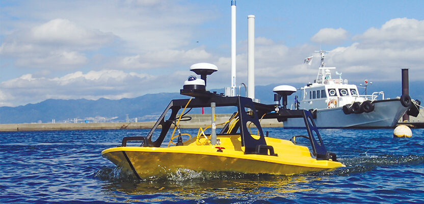
Within the NOMEC plan, it is expected that the pace of seafloor mapping will accelerate as the deep-water mapping efforts are completed and advancements in technology are deployed at scale. In fact, technology is at the heart of the NOMEC strategy. NOMEC proposes to develop and mature new and emerging science and technologies that will include unmanned systems, high-bandwidth communications, and artificial intelligence to plot the seafloor.
The crop of currently available technologies employed by the country’s hydrographers have come a very long way from what was first used by the U.S. Coast Survey a century ago. Sea depths used to be measured by using a weighted flax rope, dropping it over the side of a vessel, and waiting to record the length of the line once the sinker hit bottom. These days, bathymetric data can be efficiently measured using a combination of sonar, lidar and airborne technologies.
Sonar is the same technology that was used to draw the famous seafloor map created by Bruce Heezen and Marie Tharp in the 1950s and ‘60s. They based their work on translated sonar profile data of the Atlantic Ocean floor. Then some 30 years later, seafloor maps were further improved and expanded by Walter Smith and David Sandwell when they combined measurements of the Earth’s gravity field and its effect on water masses along with more advanced satellite altimetry.
“I think things are booming,” says Brennan when asked about the state of mapping technologies available for seafloor mapping. “While we have not seen major advancements in sonar technology in the last 10 years, what we have seen in that arena are improvements in the quality of the data that sonars are putting out. Also, the depth of the information extracted from each pulse of sound is growing with the advent of multi-frequency sonars, water column and backscatter.”
Brennan is also optimistic about the availability of newer technologies, especially unmanned systems. “Where I see most of the action these days is in automating the delivery vehicles,” he says. “We are seeing great strides in developing the technology to support the unmanned systems that carry our sonars and positioning systems.”
He also mentions the advancements in telemetry, artificial intelligence, and advanced hull forms that have greater sea-keeping ability to provide better sonar data.
“It is clear that if we are going to complete the mapping of our EEZ by 2040, including the shallow areas, we will need unmanned systems to serve as force multipliers to help us do that,” he says. “Otherwise, we will need a fleet of ships more than 10 times the number we have right now working round the clock.”
Automating the mapping process will help speed things up, Brennan points out, highlighting their current progress on the topic.
“We are hard at work to create automated processes on board the vessel and ashore to prepare for this tsunami of data that is going to start rolling in. If we cannot keep up with the processing and product creation needed to realize the value of the data we collect, then all the advancement offshore is of no use,” he says. “We must get the data to the people needing to make decisions whether they are mariners, scientists, or policy makers.”
Into the Wide Blue Yonder
Because the size of the United States EEZ is immense, collecting bathymetric data to meet the NOMEC’s deadline will be a challenge for federal agencies to complete by themselves. Asked about the role of private sector in this undertaking, Brennan says a big job such as seafloor mapping will take an “all hands on deck” approach.
Creating an atlas of the U.S. seafloor will be expensive, thus building public and private partnerships to map, explore, and characterize the EEZ is one of the main goals of the NOMEC strategy. That integrated and collaborative approach to seafloor mapping is the best way to move forward, and the contribution the private sector will play in seafloor mapping cannot be dismissed.
Brennan cites how companies not only systematically acquire multibeam data on their way to and from their project areas to provide ever-widening corridors of well-mapped seafloor, but they also make this data available. “These companies are placing that data into the public arena for use in our efforts to fully map the EEZ,” he adds.
What is even more impressive is that private companies have also been developing innovative technologies that dramatically cut the cost of a day at sea to allow more data to be acquired. “I think the private sector has played a large role in this effort thus far and expect them to continue to offer innovative solutions,” he says.
For someone who is now at the forefront of unraveling the depths of the seas, Brennan only began to understand and appreciate all the science behind ocean mapping and how big the challenge was when he came to work for NOAA. What made a huge impact on his life was a boating trip with his father.
“When I was a junior in high school, my father bought a small boat and we began to cruise the coastal waters of Florida and ultimately ventured across the Gulf Stream to visit the Bahamas,” he says. “That one trip changed the direction of my life and all I wanted to do was to be on water.”
And indeed, being on water seems to be his vocation. During this interview, Brennan learned that he has been appointed to be the next director of NOAA’s Office of Coast Survey, a position that also carries the title of National Hydrographer.
“The work I do to map the ocean floor touches so many other elements of science and value to our population,” he says. “While the early work I did was exciting because of the adventure, I find the work I do today as exciting because of the collaboration and the energy that is needed to complete this epic task of mapping the Earth’s oceans.”