Category Archives: Enviro/Ag

Out to Sea with Dr. Larry Mayer
Long-time oceanographer shares insights about mapping the ocean floor and the innovative technology needed to do it.

NSPS, Geospatial Firms and Others Support IIJA
In a letter to U.S. senators, the National Society of Professional Surveyors, geospatial firms, AEC firms, and transportation entities urged all senators to support the Infrastructure Investment and Jobs Act (IIJA), saying it will “provide meaningful economic and quality of life enhancements to communities across the country.” In all, 76 firms urged passage of the...

xyHt Weekly News Recap: 07/16/2021
Esri Releases New Predictive 2050 Global Land Cover Map Esri Awards GIS Users for Innovations Velodyne Lidar Partners with NVIDIA Metropolis for Infrastructure Solutions Zoom75 & Zoom 95 – The New GeoMax Robotic Total Stations Lidar Helps Reveal Radiation Hot Spots at Chernobyl GIS-Pro 2021: October 3-6, 2021 Setting the Record Straight: The RETAIN Act...

MAPLand Act Gathering Support
The Modernizing Access to our Public Land (MAPLand) Act, which would direct federal land management agencies to digitize and standardize mapping records, has won the support of the National Society of Professional Surveyors (NSPS). The legislation, H.R. 3113, will allow hunters, anglers, and millions of other federal land users to access essential information about public lands...
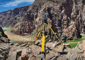
Moving Water in the Grand Canyon
Grand Canyon National Park (GCNP) is one of those unforgettable places that can change a person’s life.
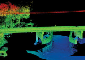
The Challenges of Near-shore Hydrographic Surveys
Near-shore hydrographic surveying can be a challenging task, especially if the conditions are not ideal to collect the required data.