Category Archives: Enviro/Ag
Digitizing America’s Coast
Legislation passed by congress and signed by the president codifies NOAA’s exemplary digital coast program Geospatial professionals and coastal communities are celebrating the passage of the Digital Coast Act (DCA) by remembering the coordinated efforts from the numerous public and private stakeholders that were necessary to help pass this important legislation. The intent of this...

senseFly Expands its Line of Fixed-Wing Mapping Drones
A mapping drone in the $10,000 price range might sound like one of those things that’s too good to be true. And up until now, maybe it was. A Swiss company called senseFly, a global leader in fixed-wing mapping drones, has expanded its flagship eBee X drone solution with the launch of eBee Geo. The...

Digital Coast Act Becomes Law This Week
The Digital Coast Act, now approved by both chambers of Congress, will become law this week, and that is a significant step toward expanding and making accessible geospatial data to support environmental and economic development activities in the coastal regions of the United States. The bill creates a program within the National Oceanic and Atmospheric...

Geospatial Adventure: Ghost Towns and Diamond Mine Memories
Diamond mine memories: A century or so ago, miners in the small settlement of Pomona pulled 50,000 carats of diamonds a month from the vast, arid nothingness of land called the Sperrgebiet—10,000 square miles of coastal desert in southwestern Namibia in Africa. The sandy ground has long since given up the last of its precious...

Doers: Christoph Hinte
Christoph Hinte on 25 years at Intergeo Christoph Hinte is the organizer of INTERGEO, the world’s biggest annual geospatial trade fair and conference. As CEO of HINTE Expo & Conference, he has been involved in the development and strategy of INTERGEO events since in 1995. Hinte tells xyHt why this year’s event, October 13 to...
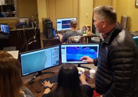
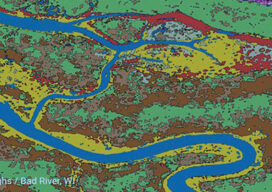
Army Corps’ (JALBTCX) data improves coastal projects
In a hotel conference room on Long Island, New York, a team of experts is processing data and information on computers. Alongside them is a large display monitor that is projecting the information. The team is the Joint Airborne Lidar Bathymetry Technical Center of Expertise (JALBTCX). “It’s a beautiful thing. On the screen they are...