Category Archives: Hydro/Marine
The Responsibility to Map the U.S. Coastline
(And the Inevitability of New Geodetic and Tidal Datums) Since the arrival of the first pilgrims to the North American continent, there has been a need for precise knowledge of the coastline of the new country, and the reasons are obvious. Arrival by boat was the only alternative when crossing the Atlantic and escaping religious...
Hydrospatial: The Next Frontier of Hydrography
Staying Fluid The theme for US Hydro 2023 reflects the relevance that our profession and related sciences have in the marine geospatial world. In some circles we are discussing the profile of “the hydrographer of the future” (the Canadian Hydrographic Service is leading a series of workshops on this topic), what they have to learn...

Rachel Layko
23 Young Geospatial Professionals to Watch in 2023 – 9 of 23 Name: Rachel LaykoCompany: Arizona State University Current position: PhD CandidateAge: 25 Education: BS in biology; minor in marine science, The College of William & Mary In the PhD program at Arizona State University, Layko is working to bring her geospatial background...
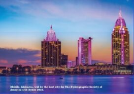
THSOA: New Website and US Hydro 2023
Staying Fluid The Hydrographic Society of America (THSOA) is a 501(c)3 non-profit organization committed to promoting education in hydrography, inshore surveying, inland waters surveying, offshore surveying, positioning and mapping/charting, including related earth sciences. We have organized in a National Board, including the president, secretary, treasurer, and four trustees, and our members by geographical regions, in...
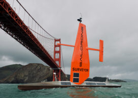
The Ocean Mapping Imperative
Wind and solar-powered uncrewed surface vehicles offer a boost to global surveying efforts. Since 2017, the Seabed 2030 initiative has raised awareness about the importance of mapping the entire seafloor to support a healthy and resilient ocean for the well-being of the entire planet. This partnership between the Nippon Foundation, the International Hydrographic Organization (IHO),...
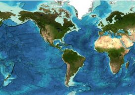
Staying Fluid: The Ocean Decade
More than 23 percent of the ocean seabed is now mapped Seabed 2030 is a partnership between the Nippon Foundation and the General Bathymetric Chart of the Oceans (GEBCO) and aims to map the entire planet’s seabed by 2030. To date, the project has mapped around 23.4 percent of the seabed. The latest data was...