Category Archives: Space

Capturing Today’s (and Tomorrow’s) Constellations
Access to all GNSS constellations provides better data, better results Enhancements made to improve the handling of satellite systems (also called constellations) and the increasing number of signals produced by these systems provide a tangible benefit to any solution that requires precise positioning. Depending on the time of day and the geographical location, some of...
Looking Forward: Air, Space, and Ground
This is my favorite time of the year here at xyHt. We bring you not only the regular issue, but our annual Heights supplement, created in conjunction with our friends at MAPPS to address all things aerial. The history of aerial photography is relatively brief. But in that time, technological advances have covered a lot...

xyHt Weekly News Recap: 07/16/2021
Esri Releases New Predictive 2050 Global Land Cover Map Esri Awards GIS Users for Innovations Velodyne Lidar Partners with NVIDIA Metropolis for Infrastructure Solutions Zoom75 & Zoom 95 – The New GeoMax Robotic Total Stations Lidar Helps Reveal Radiation Hot Spots at Chernobyl GIS-Pro 2021: October 3-6, 2021 Setting the Record Straight: The RETAIN Act...
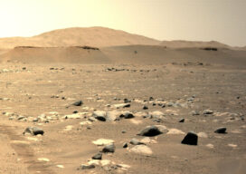
Ingenuity Breaks New Ground for UAVs – on Mars
NASA’s Ingenuity Mars Helicopter continues to set records, flying faster and farther on Sunday, April 25, 2021 than in any tests it went through on Earth. The helicopter took off at 4:31 a.m. EDT (1:31 a.m. PDT), or 12:33 p.m. local Mars time, rising 16 feet (5 meters) – the same altitude as its second flight....
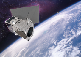
Remote Sensing with Satellites
The commercial satellite remote-sensing industry has rapidly evolved over the past two decades, from both the technology and market perspectives, so that satellite imagery has become an integral part of many industries. For example, national, high-resolution maps greatly benefit the civil government and mapping portal industry, especially with cities refreshed on an annual or more-frequent...

Dr. Gladys West
The quiet dedication of a hidden hero who made satellite geodesy and global positioning possible. As early as high school, the focused determination of Dr. Gladys West would see her rise to make key contributions to one of the most impactful scientific endeavors of our age. In our recent interview with xyHt magazine, West gave...