
West and her sister in Sutherland, Virginia
The quiet dedication of a hidden hero who made satellite geodesy and global positioning possible.
As early as high school, the focused determination of Dr. Gladys West would see her rise to make key contributions to one of the most impactful scientific endeavors of our age. In our recent interview with xyHt magazine, West gave us a glimpse into her personal and scientific journey.
Born Gladys Mae Brown in Sutherland Virginia in 1930, this eager high-school student at the Dinwiddie Training School (as it was called at the time) viewed the opportunity for a scholarship as a way towards a better life, and a way to “get off the farm.” West said that employment opportunities in rural Dinwiddie County in the 1930s and 1940s were mostly limited to work in the fields of tobacco, corn, and cotton, or in tobacco processing factories, and she saw education as the key to other opportunities.
The 1940s and 1950s were the beginnings of a complete paradigm shift in science, especially space exploration and computers. Events such as the launch of Sputnik, the first artificial satellite, set the scientific and academic worlds on fire. Focus on STEM subjects (long before it was called STEM) boomed, as did the institutions—both civilian and defense related—engaged in these new fields of research and development.
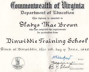
The hard-won diploma that launched West into higher ed and a career in math.
West said that in high school she was not particularly interested in any one subject but focused on being proficient in all subjects. Traveling 17 miles each way, from the family farm and back by school bus, left no time for extracurricular school activities that were limited to school times, so she concentrated on her studies. With the help of dedicated educators, West and her best friend did take top honors and headed off to Virginia State College (now Virginia State University, VSU). West began an adventure she had not imagined would contribute to developments with such tremendous scientific and societal impacts.
The Unseen Magicians
I often wonder how many people even briefly reflect on the very real magic behind the blue dot on the map on their phone that is guiding them to a destination, or the coordinates their surveying GPS instrument displays. None of this would have been possible without an amazing confluence of multiple scientific breakthroughs, developed through a process of circular dependencies, that grew out of the mid-20th century.
The foundational elements of GPS include precise time, refined orbits, and radio science, but people tend to forget that if you are using GPS to derive a position on the Earth, you must also know the true nature of the shape of the Earth. Geodesy, and the burgeoning science of satellite geodesy, played just as important a role as the other elements, yet we hear little about how those refinements came about. From this modern geodesy also came a better understanding of how the irregular shape (and mass) of the Earth—and specifically the gravitational parameters—affect refined orbits. In turn, the speed and distance from the Earth (gravity) influence orbiting vehicles, dictating relativistic time effects that also have to be accounted for.
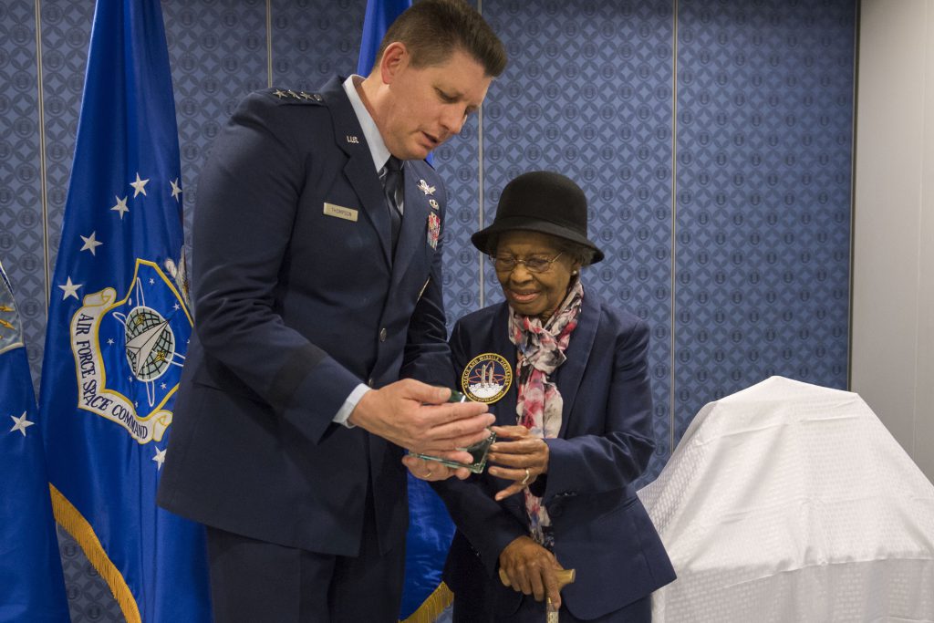
Lt. Gen. David Thompson, Air Force Space Command vice commander, presents West with the Air Force Space and Missile Pioneers award.
Some of the most brilliant minds of that era conceptualized and theorized how all of these elements could be brought together to revolutionize positioning, navigation, and timing (PNT), but the proofs had to be derived from masses of data—much of which did not exist yet—through much computing, testing, and refining. The terms “big data” and “data scientists” are well known today, but more than six decades ago, one of the first truly extraordinary “big data” projects got under way in the relatively obscure field of satellite geodesy, using what would be considered primitive computers. Such limited tools and resources put a premium on the human math skills needed to get it all right.
We hear a lot about certain figures in the development of GPS, for example Roger Easton, whose substantial body of scientific work included the U.S. Navy Timation project (early satellite navigation). Then there are Richard Schwartz and Hugo FrueHauf and their work on GPS satellite design; James Spilker’s work on fundamental signal structures; Dr. Brad Parkinson (former USAF Colonel) who led the team that put the system together; and pioneers in the development of end-user equipment like Charlie Trimble. In fact, four of the above people were awarded the 2019 Queen Elizabeth Prize for Engineering.
While I imagine that honors committees do not wish to appear to overlook the larger teams as they grant honors to individuals, the work of many dedicated team members has often never been acknowledged. In 2018 I noticed the name Gladys B. West and her scientific achievements among the profiles in the BBC’s “100 Women” series. I wondered (as others did in subsequent news items) how the work of this exemplary contributor to the hidden magic behind GPS had been overlooked for so long.
We are heartened to see in recent years numerous articles about and honors bestowed on West (more on those later). I asked her about this new fame, and she said it is fun and she is honored, but at the time she and her colleagues were not thinking so much about anything like GPS or what other future developments might come from their work. Rather, “The most important thing was to do the work at hand, and to make sure it was correct.”

Ira and Gladys West at their wedding.
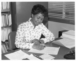
Computation & Analysis Building 218, NWL
West thrived at Virginia State College, and after earning her Bachelor of Science, she taught high-school math and science for two years while saving up to return to VSU and complete her Master of Mathematics.
That era was also one of great societal upheaval and change. Although some progress had been made, women and other minorities still faced significant inequality. In those days, teaching was a common career path for women and minority graduates as there were still many closed doors in other fields. But West wanted to find another path.
Having returned to teaching for a few months after earning her Masters, West began looking for a career that might earn more to help her family as well as provide fresh challenges. She applied for a posting for mathematicians needed at a remote defense research installation in coastal Virginia, but she initially had to turn down an interview offer due to limited transportation options. But she was contacted again several weeks later and offered the job without the interview.
The Naval Weapons Laboratory (now called the Naval Surface Warfare Center) is in Dahlgren, Virginia, named for Rear Admiral John H. Dahlgren who is often called the father of modern naval warfare. West arrived at this remote posting in 1956 as a mathematician.
She said that the reception was generally warm as many such institutions were trying to integrate their operations and openly reach out to potential recruits among women and minority graduates. But she notes that she was only the fourth black recruit at the facility; there were not many women in technical roles; and there were still other reminders of traditional barriers.
Another young black mathematician at Dahlgren was Ira West. Though Gladys says she was mostly too focused on her work at first to socialize, they grew a bond and were married in 1957.
West raised children and did volunteer work all while publishing her research.
Life at Dahlgren, says West (we continue to refer to Gladys as West and her husband as Ira), was isolated: “We would have to take a Greyhound bus to get anywhere, to a city or town. But I was from the country, so it seemed fine to me.” Dahlgren was a self-contained and high-security installation. There were dormitories on the base for the young workers: one side for the men and one for the women.
Some of her first work there was computing range tables for weapons systems, which was in line with the traditional ordnance development role of the facility. But several new missions were beginning, like that of submarine-based missiles (an area Ira would work in) and satellite geodesy. The start of the satellite era in 1957 brought great career changes for West. Both Wests rose to roles as supervising mathematicians.
“There were some brilliant people at Dahlgren coming up with all kinds of algorithms to study so many things, and we had to do the work to compute these,” said West, who at first served in a support role but grew in her responsibilities, was steadily promoted, and published research projects.
“We had these large computers—they were very big—and had to be fed by punch cards. All the punch cards had to be checked.” West explained that these early computers, like the IBM 7090 (circa 1960), were operated at the machine language level: “They each had their own programming language.”
Some of the early projects did not appear to be directly related to defense or satellite navigation but were more to understand the fundamental nature of orbits and gravity. A key astronomical study West worked on looked at the orbit of Pluto with relation to Neptune, which entailed 5 billion calculations (and 100 hours of processing time). With the computing power of today, it might theoretically be possible to do this with the processor in your phone, but at the time, Project 29V, as it was known, was only possible through the efforts of West and a team of fellow brilliant mathematicians.
The project was given a special group achievement award in 1964, the same year a new building was dedicated for the computational analysis team. “We were so proud of that building,” said West, “but I think it has been taken down since—they used asbestos in buildings then.”
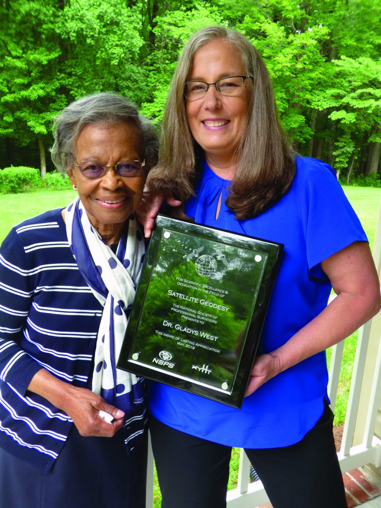
NSPS president Lisa Van Horn presents West with an award of lasting appreciation.
Orbits, Ellipsoids, and Geoids
“The Earth is not round,” said West, “and we had to figure out the shape, precisely,” not just to develop the all-important geoid but also to determine precise orbits and a refined reference surface (ellipsoid).
Without these three key elements, using satellites to determine a position on the Earth would not be possible. The better these elements are defined, and continually refined, the better the resulting positions. West’s work contributed to the refinement of all three.
 A geoid can be an esoteric concept to anyone outside scientific or geodetic communities. It is a model of the irregular Earth where gravity would be equal, a kind of theoretical “sea level” of gravity. Orthometric height can be determined by knowing the geoid value for any given position (e.g., latitude/longitude, which satellites could provide) and the satellite-derived height above a reference “ellipsoid” (a regular geometric shape approximating the oblate shape of the Earth, which can be mathematically related to the orbit references).
Orthometric height is what the layperson would refer to as “elevation” or “elevation above sea level.” Prior to satellite-based methods, determining elevations was by laborious surveying—“differential leveling” over long distances—or using barometers that could be inaccurate to hundreds of feet. I reflect on this now, looking at my old surveying barometers that are somewhat of an anachronism since the advent of satellite positioning.
Now with GPS and those models of the Earth that West helped develop, both horizontal positions and elevations can be determined within centimeters (even in real-time) anywhere on the Earth. For example, these elements running unseen in the background give you an up-to-date position and elevation in that recreational GPS you take hiking.
West used complex algorithms to study the various forces that distort the shape of the Earth (e.g., gravity, tides) and subsequently how such forces perturb satellite orbits. This was especially difficult to determine over oceans, an area of study of great interest to the Navy.
Much of the work was strictly classified—West had top-secret clearance—but subsequently released papers by West revealed the complexity of such computational concepts. Some of this work is detailed in her 1969 technical report: “A STRETCH program, which computes gravity coefficients from geoid heights.” This work was done with the 7030 STRETCH, IBM’s first transistorized computer.
The advent of satellites provided a wealth of new data from which to repaint models of the Earth. Scientists began using Doppler (from even the very first satellite) to determine positions on the Earth, and orbits were tracked with both optical and signal methods.
West used Doppler data in her work, and in 1975 she was named project manager for the work done at Dahlgren with data from the Geodynamics Experimental Ocean Satellite 3, or GEOS-3 (shortly after the facility had been renamed the Naval Surface Warfare Center, or MSWC). The GEOS-3 provided not only Doppler data, but also early radar altimetry data, greatly improving observed surface heights for oceans.
West and colleagues at Dahlgren worked in concert with research teams at other facilities such as the Naval Research Laboratory in Washington, D.C., and all over the country. Sadly, there were barriers to collaboration, especially as travel was often quite difficult for some members of the team. West noted: “There were hotels that did not want black people staying there.”
More Than GPS
West was project manager for another significant project, the 1978 SEASAT mission, which among other features carried the first example of satellite-based synthetic aperture radar (SAR). SAR is now used for many civilian applications as well, such as subsidence monitoring for large-scale tunneling and landslide studies and monitoring.
Her 1981 technical paper, “SEASAT Satellite Radar Altimetry Data Processing System,” outlines how radar altimetry data was combined with the Doppler precise orbits to correct for atmospheric and environmental effects and tidal, ionospheric, tropospheric, and barometric data to produce improved geoid heights and vertical deflection data.
While the SEASAT mission lasted only 106 days (because of electrical system issues), West says much good data was retrieved/gained from the global array of ground-tracking stations. This work also led to refinements in the all-important mean-earth ellipsoid, described in another 1981 technical paper she authored.
West continued her groundbreaking work while raising three children, earning her Master of Public Administration in 1973, and later her PhD in Public Administration. She also found time to serve on the board of the credit union and the local school board.
West’s work throughout her distinguished 42 years at Dahlgren included other projects not directly related to GPS, but she continued her work in that field as she studied and refined the key data elements. I would love to present here her many papers related to GPS in detail; due to space limitations, we will provide links to some online.
West published many key papers, and while such publications might seem too esoteric for general consumption, her body of work illustrates an important point about impactful scientific research—especially with fruit we so easily take for granted: Someone had to do the work. It was hard, skilled work and often thankless, and it takes a special kind of dedication to do it—and to get it right.
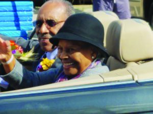
Gladys West at the King George Fall Festival.
Recognition
Society has undergone great changes since West’s initial groundbreaking work. The benefits of early scientific works that are now declassified have become more widely appreciated, and hidden histories and hidden figures are now finding recognition.
An example is the book and subsequent 2016 biographical drama film, Hidden Figures, about black female mathematicians who worked at NASA during the space race. Another Navy mathematician, Rear Admiral Grace Hopper, also received international acclaim for her work in computing, but for West broader recognition did not come until relatively recently.
In 2018, one of West’s sorority sisters read her biography and recognized that her friend was indeed a “Hidden Figure” for GPS. Articles celebrating West soon appeared in local, national, and international publications. She was honored by the Virginia State legislature in 2018, was featured in the homecoming parade of her alma mater, and received an award as one of Dominion Energy’s “Strong Men and Women” in 2019. Additionally, West was inducted into the USAF Space and Missile Pioneers Hall of Fame, one of their highest honors.
In researching her story for xyHt we contacted the Air Force Space Command history office; they provided a wealth of documents and introduced us to West’s daughter, Dr. Carolyn Oglesby, who gave us access to a wonderful photographic archive.
In June of 2019, Lisa van Horn, president of the National Society of Professional Surveyors, presented West with an award of appreciation for her work in satellite geodesy and her continuing STEM outreach to youth.
I cannot fully express how wonderful it was—and an honor—to speak with West who witnessed and contributed to the development of the most successful and impactful scientific endeavors of all time. We also recognize the important work of her husband, Ira West.
West speaks softly but very straight-forward; her modesty is mixed with appropriate recognition of her own skills and accomplishments. Her work and triumphs in overcoming barriers present an inspiring picture of a life committed to family, faith, community, and work. Indeed, she continues to mentor and inspire youth, speaking regularly at schools and events.
I asked her what advice she might have for young people who are considering STEM careers, and her response contained very practical steps: “Concentrate on your core subjects, take a look around at all of the [options], and choose what you might be interested in”—and of course, “study hard.”
That is exactly the path that young Gladys Brown took, and what a journey followed! Sometime after you’ve been out in the field surveying with GPS or are looking at the map on your phone, raise a glass to Dr. Gladys M. West.