Category Archives: Spatial IT/GIS

Digital Coast Act Becomes Law This Week
The Digital Coast Act, now approved by both chambers of Congress, will become law this week, and that is a significant step toward expanding and making accessible geospatial data to support environmental and economic development activities in the coastal regions of the United States. The bill creates a program within the National Oceanic and Atmospheric...
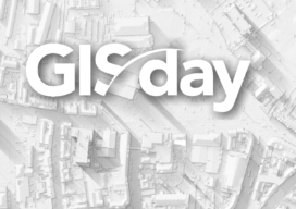
GIS Day 2020
Do you have “Open University” days where you are? Here in Southampton, in the United Kingdom, every March each university opens its doors to the public. Students, staff and spouses have stands around the university where they do demonstrations or share their science subjects. Most of this is hands-on and each is a great day...
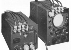
The Return of Loran
An obsolete WWII navigation system is making a comeback In the 1980s, I used Loran-C to navigate on sailing trips off the U.S. East Coast. It had an accuracy of a few hundred feet and required interpreting blue, magenta, black, and green lines that were overprinted on nautical charts. The system was a modernized version, launched...

iPhone Pro 12 – Survey device??
There is a buzz on the underground, geospatial people are tweeting about lidar in the new iPhone 12 Pro. What really escalated it all was Matterport releasing a new scan app on the Apple store, it was then followed by a few geospatial people alluding to be able to scan cities and even map rooms...

Update: GeoBIM and 3D GeoInfo Conference
EuroSDR is a not-for-profit organization linking national mapping and cadastral agencies with research institutes and universities in Europe for the purpose of applied research in spatial data provision, management and delivery. Over the last few years they have ran several projects, one of particular interest being in the use of BIM (building information modeling) and geo-data in...
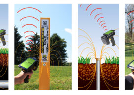
InfraMarker on Display at Esri Infrastructure Conference
Berntsen International, the leader in infrastructure marking solutions, has partnered with CHA Integrated Solutions (formerly NovaraGeo Solutions) to provide its InfraMarker RFID capability within the Corrivo mobile software platform, delivering Traceable, Verifiable and Complete (TVC) field asset data. See it at the Esri Infrastructure Management & GIS Conference on October 29. CHA Integrated Solutions will...