Category Archives: Spatial IT/GIS

NSPS, Geospatial Firms and Others Support IIJA
In a letter to U.S. senators, the National Society of Professional Surveyors, geospatial firms, AEC firms, and transportation entities urged all senators to support the Infrastructure Investment and Jobs Act (IIJA), saying it will “provide meaningful economic and quality of life enhancements to communities across the country.” In all, 76 firms urged passage of the...
Teaching the Future
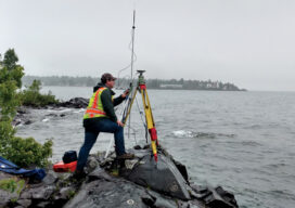
A small university on Michigan’s Upper Peninsula is educating the next generation of surveyors and geospatial engineers

xyHt Weekly News Recap: 07/16/2021
Esri Releases New Predictive 2050 Global Land Cover Map Esri Awards GIS Users for Innovations Velodyne Lidar Partners with NVIDIA Metropolis for Infrastructure Solutions Zoom75 & Zoom 95 – The New GeoMax Robotic Total Stations Lidar Helps Reveal Radiation Hot Spots at Chernobyl GIS-Pro 2021: October 3-6, 2021 Setting the Record Straight: The RETAIN Act...

Surveying and GIS: It’s ‘And’, not ‘Or’
When I graduated from college several decades ago, a retiring drafting professor said to me, “The things that are going to change during your career are difficult to comprehend. I wish I was going to be around to be part of it.”

Saving the Big Cats with GIS
Location intelligence is helping livestock herders and lions peacefully share the land in Africa

When Mapping Goes Viral
Digital mapping has boomed during the COVID-19 pandemic. From tracking cases to allocating vaccines, GIS technology is at the frontline of the war to beat the virus.