What is it, and how will it work?
Mapping has traditionally been the task of visually charting big outdoor spaces with pretty hills that look great with a few contours around them. Throw in a bit of hillshade, and you have a cartophile’s dream.
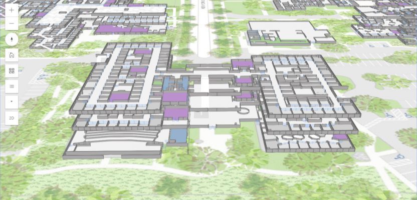
The location intelligence company Esri, that has driven the market to do much more than simple consumer maps with ArcGIS, changed the rules of the game again a few years ago when they introduced ArcGIS Pro, the first real 3D GIS that changed the way we analyze and interact with spatial data.
Now, by using the technology developed within the ArcGIS Pro engine, Esri is enabling mapping at the micro scale; they’re making it possible to map inside spaces but still use the powerful analytics capabilities that the GIS analyst is used to.
What is ArcGIS Indoors? I talked with Esri’s director of professional services, Brian Cross, to see what’s beneath the hood and how it could change the game again. Let’s be clear from the start: ArcGIS Indoors is a separate software in the Esri suite that operates seamlessly on top of the ArcGIS Pro platform. It will include new web and mobile applications that will allow links with indoor positioning systems (IPS) for precise indoor location.
Why Indoor Mapping?
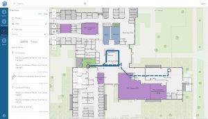
The Indoors web app in kiosk mode for touchscreen devices.
Why do we need an indoor mapping solution? As Cross explains, “We apply management and analysis for assets every day, and we have gotten used to that in the world of outdoor mapping. For operational efficiency, there is a need to now look at the smaller scale so that we can apply those methods of analysis to places like hospitals, education facilities, and even the office.”
Initially, this could seem a little crazy, but delve deeper and you realize that they have struck gold. I’ll explain with three different scenarios in which this software will change our world.
Education Facilities
Buildings can be made more efficient in many ways. This could include adjusting heating based on which rooms will be full or empty. Even the simple student timetable can be improved by using IPS devices: the students can use indoor navigation linked to their calendars to make sure they not only know what time they need to be at the next class, but also the quickest way to get there because ArcGIS Indoors will monitor footfall.
Beyond the student experience, however, are the university workers who make sure the campus is safe, in good repair, and accessible every day.
Oil & Gas Facilities
The obvious case here is health and safety. By using the indoor application, teams will have the ability to track and mitigate workers who might be at risk. There is also the potential to geofence (add perimeter alerts) a location where a hazard or dangerous situation has occurred, and immediate information can be translated in real-time.
Hospitals
Spaces and facilities can be altered based on footfall analysis, equipment can be better placed, and managing the temperature could provide huge energy efficiencies.
The most impactful use case, though, lies in managing critical items that move in a hospital as this can be costly and dangerous, including equipment, key personnel, even patients or time-sensitive medication.
Furthermore, we can see how disease spreads by using AI to review logged cases, and we can better protect the vulnerable within communities.
BIM or GIS?
Those of you who work with BIM will be saying that some of this falls into the environmental plan requirement and will have a BIM element, so why is it in a GIS? Esri has already thought about this. The software is capable of consuming BIM formats (I’ve played with Revit models with great success), and, furthermore, the environment feels like BIM360 but with a map.
The official word from Esri is that this software is optimised to work with BIM, although they categorically state that this is not BIM; this is a GIS that works with BIM.
Mobile App
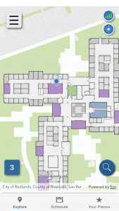
The mobile application uses indoor positioning systems to show your location on the map. The web application has indoor wayfinding.
Let’s talk about that mobile application. It uses the existing technology within your phone (both Apple and Android) to link to IPS sources such as Bluetooth beacons, light, and wifi.
Although there has been a bit of a buzz over the recent announcement Esri made about acquiring Indoo.rs, the system doesn’t solely rely on any one IPS type and can link to many of the systems available at the moment. Through the new R&D center in Vienna, Esri is investing a lot of time into ArcGIS Indoors to ensure it can work with any IPS standard.
By having accurate indoor positioning, the mobile application can be set to find your way to a tin of baked beans in a shop or set alarms if a certain (virtual) barrier is crossed: the possibilities are endless.
The thing that interests me the most is the potential customers. I get that this will be used by all kinds of geospatial professionals who have a responsibility to ensure the safety and wellbeing of their staff and the teams trying to make their businesses more efficient.
But the user I hadn’t considered was designers. Esri has been working with the design industry to make the software easier to use for a slightly wider audience to make it accessible to these creative and design-based industries. It will enable them to create efficient spaces, so I can see huge value in it.
Because Esri is a world-leading geospatial software supplier, its introduction of a new indoor mapping product can only mean one thing: indoor mapping is on its way up and could change the way we look at both macro- and micro-scale mapping. The fact that they are now working with IPS providers to ensure blue dot position and to provide users with geospatial analytic capabilities will mean that they will be the one to watch in the coming months.