Category Archives: Spatial IT/GIS

The Problem with GIS and Augmented, Virtual, and Mixed Reality
Over the last few years, altered realities technology has exploded, and now, with the introduction of Apple’s ARKit and Android’s ARCore, AR, MR, and VR are well within the reach of the non-developer. I can confirm this as I’ve created a few AR apps and MR apps myself over the last few months, with no experience...
Making Heightmaps
There is no hiding it: I’ve been building a lot of 3D data recently, partly to sell, partly to fuel my adventures into augmented reality (if you’re interested in me adding this to the blog, please say!). The main vital thing has been the heightmap. Providing Certainty in 3D Heights What is a heightmap, you...

SWAMS
Using GIS for utility asset management: the Water Supply Asset Management System The cost of maintaining water system utilities is a concern of all responsible administrative authorities. And utilities are assets that need to be sustained rather than replaced again and again to provide people with quality service. Therefore, better asset management is needed; without...

The (Android) Empire Strikes Back: Mainstreaming Augmented Reality, Part 2
Let’s pick up the AR thread again and look at what the Android platform has to offer in augmented reality (AR). It was just a matter of days after Apple rolled out its ARKit SDK (software development kit) when Google followed suit with its ARCore SDK. ARCore is built on Tango technology but expands the...
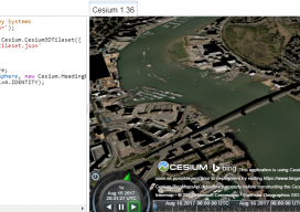
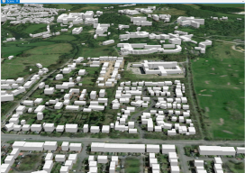
Add 3D Tiles to Cesium 1.36 to Make 3D Virtual Scenes
As blogs come, this has to be (for me) one of the longest. You see, I’ve been playing with Cesiumjs since its beginning and following the exciting beginnings of the “3D Tile” for the last 3 years. I’ve waited patiently, waiting for the moment I could share with the world how fantastic this new technology...

Night in the Afternoon: A US Solar Eclipse
What you need to know about the 2017 solar eclipse The upcoming solar eclipse will leave a 70-mile-wide trail of darkness across the United States on August 21, 2017 (see the map of the eclipse path on pages 44-45). This will be a once-in-a-lifetime event for many people. While another total solar eclipse will make...