Connecting the global development community to Earth imagery and primary analytical tools.
Nonprofits working on global development issues have had great difficulty acquiring and using a staple source of geospatial data in the form of Earth observation imagery collected by satellites. Anne Miglarese, the founder, and CEO of Radiant.Earth is working to change this.
Miglarese previously served in leadership positions in the public and private sectors – including as president and CEO of Fugro Earth Data and of PlanetiQ. She was also chief of NOAA’s Coastal Services Center, where she directed remote sensing and GIS programs for more than a decade, and she was the founding chairperson of the U.S. National Geospatial Advisory Committee.
The following is part of my recent interview with her.
What is Radiant.Earth’s mission?
Radiant.Earth’s mission focuses on a fundamental problem that has plagued the remote sensing community for three decades: it is too difficult to find the right data for your project; it takes too long to physically gain access to it and evaluate its fitness for use; it takes too many resources for many organizations who want to use the technology.
This is a particularly significant barrier for those working in the not-for-profit sector on global development applications. With cloud computing, the ability to discover, evaluate, and analyze data quickly is game-changing.
Our mission is to connect the global development community worldwide to Earth imagery and primary analytical tools that help them meet their critical challenges. While we’ve seen the aggregation of some datasets, generally those datasets are commercial.
At present, you can go to AWS [Amazon Web Services] to discover Landsat and Sentinel data, but people must be experienced users to find their way there and to find the right images. The platform that we have developed allows less-sophisticated users to quickly and easily discover data for their mission and their challenge on the ground.
We have Landsat 8, Sentinel 2A, Sentinel 2B, and project-based drone data available via the platform. We are negotiating with several organizations to get additional satellite-based and airborne content. A year from now, we hope to host a broader collection of open data on the platform from other government-based satellites as well as aerial photography programs and drone projects from our primary customer base.
We are also in discussions with a commercial entity about hosting data that has previously been licensed by a primary customer in compliance with that specific license. I hope that we will have a mixture of commercial data, as well as open data and be able to expose that commercial data while protecting the original license.
Do these other organizations give you their data as a charitable contribution?
For commercial entities, it’s a mix of charitable as well as compensation-based data. Philanthropic organizations, in many cases, have purchased large amounts of commercial data to support their grantees’ programs, which they usually store on their hard drives. When they want to share it with a partner who has a legal right to use that data, they ship the hard drives around the globe.
Our platform allows users not just to find and view data, but also to share them across their teams. We are working to put security on the platform that will ensure that the commercial companies’ licenses are respected but drive down the friction of getting those data to the people who need them most.
What do you provide that other EO data platforms are not already providing?
We are a neutral organization, not a commercial or government entity. We are focused on getting the best data into the hands of our customers to solve a problem, whether that’s open data or commercial data. Many of our primary constituents hunger to be able to consult with someone who doesn’t have a stake in how the relationship plays out. I also think that the vast majority of the government platforms are focused on one source of imagery. Our vision is to get as much imagery as we can, and not just from government sources.
We differ from AirBus, Digital Globe, or Planet is that we do serve out a variety of open data and a person could use the platform without a subscription service. So, that is pretty self-evident. Ultimately, I hope that we expose a substantial amount of government, open data, and commercial data to help our customers find the right data sets and lower the friction through the entire process.
What’s the status of your platform?
We launched the platform to a limited group in late September of 2017. It is a minimum viable product at this point, as with the launch of any new technology. The platform is stable.
We have sketched a technology roadmap for the next 12 months to bring additional functionality to it. This roadmap includes readying the feature of the platform for machine learning as well as a proof-of-concept project to implement blockchain technology.
What else will your platform be able to do?
Right now, we have the necessary functionality: upload, download, band registration, basic algorithms around NDVI, water maps, and the likes. So, some pretty basic remote sensing and photogrammetry tools.
In Phase 2, we will advance the functionality. An API plugin to commercial software is an essential next step. Our users—many of whom have enterprise licenses to commercial geospatial software such as Esri, Hexagon and the like—should be able to use those assets. Clearly, we are not going to spend the next five years and tens of millions of dollars developing as rich and deep a set of software tools as many of the commercial suppliers have. Instead, we want to reduce the friction for users to find and use the data. If they are more comfortable with their commercial tools and those tools are already fundamental in their workflow, then we should facilitate that interoperability.
What services do you offer?
In our original planning, we envisioned three services: the platform, the community outreach and development, and a small consultancy that we planned on launching in the summer of 2018. We found that many of our core customers needed that consulting immediately. We’re taking on specific use cases with individual organizations to help them analyze the data to see whether it supports their mission.
Some of the most intriguing use cases are with the Pulitzer Center for Crisis Reporting. They have a grant program to fund journalists around the globe to tell important stories; we are working with three of their grantees. These are journalists generally living in emerging economies who’ve never had access to satellite imagery before. However, they see the value in not only verifying and quantifying their story but also that it supports their work with compelling imagery and graphics.
Additionally, we are working with several organizations interested in using remote sensing to monitor the sustainable development goals around sanitation and disease transmission.
There are about 130 customers now working independently on the platform who are getting the imagery that they need on their own. These are still very early days for the platform, and we have further development to undertake to make it more robust and useful.
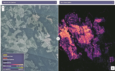
British Columbia, Canada wildfire analysis in July 2017 conducted using the Radiant.Earth platform. The Normalized Difference Vegetation Index (NDVI) was applied to pre- and post-fire imagery, and reductions in NDVI are used as an indicator to show the extent of canopy loss after wildfires caused an evacuation order of the Princeton neighborhood. Satellite imagery were retrieved from Planet.
Are you writing up your individual use cases to build an archive that people can consult for future reference?
We are, yes, absolutely. We are publishing a monthly newsletter in which we highlight many of the use cases. Additionally, we will build a library of use cases for access via our website.
The first article will be on drones and the regulation of drones in a selection of countries across the globe with differing ordinances. That will be accompanied by an infographic on the different regulatory frameworks in those countries. A series will follow this article that reviews the satellite imaging marketplace for both government and commercial systems.
All of these articles are focused on our primary constituencies: professionals in the global development community applying imaging and geospatial technology to support their missions in the field. The pieces are generally less than 1,000 words and often accompanied by an infographic.
What special challenges do nonprofits face in obtaining and using EO data and analytics?
They have many challenges. First of all, they have important missions to fulfill and they must focus on the last mile of a project in the field. Meanwhile, the geospatial industry is changing so rapidly. Keeping up to speed and being able to go to the right supplier or partner, and using the right technology, is often a challenge for them. Accordingly, the more we can do to educate them on what is changing in the marketplace and with the technology, the better.
Furthermore, many of them are challenged with connectivity issues. A significant impediment remains to gain access to the Internet, cell phone communications, and on top of that, dealing with large datasets that require extensive bandwidth. We’ve taken a regional approach to building partnerships to support the field work. We’re based in Washington, D.C., and our technology team is located in San Francisco. While we will be out in the field from time to time, meeting with customers and collaborators, we are supporting capacity development in countries where existing geospatial programs are in place. We have tried to geographically diversify where our institutional arrangements are and will be collaborating with those organizations that are building geospatial capacity.
To that end, we have agreements with UNITAR, the European Space Agency, Australia’s Commonwealth Scientific and Industrial Research Organisation, and The International Centre for Integrated Mountain Development (ICIMOD). ICIMOD is a regional intergovernmental learning and knowledge sharing center serving the eight regional member countries of the Hindu Kush Himalayas — Afghanistan, Bangladesh, Bhutan, China, India, Myanmar, Nepal, and Pakistan. Based in Kathmandu, Nepal, ICIMOD is also a SERVIR Center. We signed an agreement most recently with Code for Africa and are doing some interesting collaborative projects there.
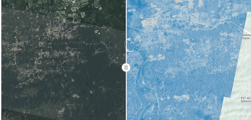
Image at top: On September 20, 2017, category 4 Hurricane Maria made landfall at Puerto Rico. Using the Radiant.Earth platform, NDVI was applied to pre- and post-flood areas. The satellite imagery, retrieved from Planet, were captured before Hurricane Maria (07/29/2017) and after (09/26/2017).