Category Archives: Spatial IT/GIS
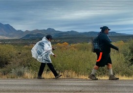
Mapping the 1874 Yavapai-Apache Exodus Trail
Modern hikers map the Exodus Trail of the Yavapai-Apache Nation with GPS. By Everett Phillips, Philipp Hummel, PLS, and Bryan Frazier; introduction by Judie Piner In 1875, both the Yavapai and the Apache people were removed from their Rio Verde reservation in Arizona and force-marched by U.S. soldiers in terrible conditions, nearly 200 miles, to...

Smart Cartography
Six examples of how old-fashioned navigation aids have been transformed into today’s smart maps Berlin, Germany 25, April 2017 | The 65th Cartography Conference run by the German Society for Cartography (DGfK) in 2017 is dedicated to smart cartography. At INTERGEO 2017, the community is showcasing its credentials as an innovative scientific discipline that excels...

GEO Business 2017 – Exhibition Preview
Next week, from May 23-24, GEO Business, the UK’s biggest geospatial exhibition and conference of the year, returns to the Business Design Centre in London. Over 3,000 visitors, from 67 countries, will be there to discover the latest new products, services and solutions from 200 leading industry innovators. Attendees will also have chance to meet...

Neutrino Beam! Scanning a Ring Tunnel
The surveying challenges for construction related to a particle accelerator are exacting—but surprisingly familiar. By Matteo Luccio Trillions of neutrinos from the sun and other celestial objects pass harmlessly and unnoticed through our bodies each second. These tiny particles are among the most abundant in the universe–a billion times more abundant than those that make...

Cadasta: Mapping Land Rights from the Bottom Up
Above: Staff of the Kenya Land Alliance review a sketch map with community members while mapping water resources in Tana River County, Kenya. Credit: Hilary Ogina, Kenya Land Alliance. Cadasta helps put people on the map with a cloud-based platform for land-ownership data. By Matteo Luccio In advanced industrial countries we take much infrastructure for...
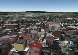
Multipatches, Point Clouds and Meshes
A Guide to 3D GIS Data Formats Moving your GIS to 3D is a daunting task. Not only are there all the vertical issues to take into account, but also a whole new world of jargon, which can, at times, be quite overwhelming. In this post you’ll find a few of the data formats that...